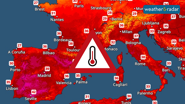
Home
Weather London
WeatherRadar
RainfallRadar
TemperatureRadar
WindRadar
LightningRadar
Weather News
Editor's Pick
Discover the app
Weather widget
Contact us
Apps
Career
    Home / Editor's Pick /

    Extreme heat in the Mediterranean: Hot air spreads

07:00
7 August 2025

Holiday hot spots
Intense heat in the Mediterranean

Temperature map showing very hot temperatures across the Mediterranean.
The Temperature Radar forecast for Sunday.

In Southern Europe, popular holiday hotspots are experiencing an intense blast of heat, with no end in sight.

Spain is currently experiencing particularly high temperatures. In Madrid, temperatures are expected to reach 40 degrees today. The country is set to heat up even further over the coming days.

The heat also continues to spread across southern France and into Italy over the coming days. On Sunday, peak temperatures of 40 degrees and above are expected in Montpellier. Temperatures in Rome will also rise above 35 degrees.

Forecast for selected cities:

Seville

Th
21
36
Fr
22
36
Sa
21
35
Su
20
32
Mo
18
31
Tu
20
35
We
22
36
Th
22
38
Fr
22
37
Sa
22
36
Su
22
37
Mo
22
38
Tu
21
37
We
19
36
Max (°C)
Min (°C)
moreless

Montpellier

Th
17
28
Fr
16
32
Sa
17
34
Su
18
34
Mo
20
33
Tu
19
31
We
20
28
Th
19
28
Fr
20
29
Sa
19
28
Su
19
29
Mo
20
30
Tu
21
31
We
21
30
Max (°C)
Min (°C)
moreless

Rome

Th
21
27
Fr
18
31
Sa
17
30
Su
18
32
Mo
18
30
Tu
21
29
We
20
32
Th
20
32
Fr
21
33
Sa
20
34
Su
20
34
Mo
21
34
Tu
21
33
We
20
31
Max (°C)
Min (°C)
moreless

The nights will not bring any relief either. Minimum temperatures will generally range between 20 and 25 degrees. The temperature curve will only start to dip next week.

Sebastian Keßler
Ryan Hathaway
More on the topic
Final thunderstorms hanging around. Before Thursday downpour. . . Wednesday, 10 June 2026
Split weather graphic showing thunderstorms and lightning activity across southeast England on the left, and a broad rain band moving east across Ireland and western UK on the right, with rain icon and a movement arrow east.
Wednesday, 10 June 2026

Before Thursday downpour

Final thunderstorms hanging around
Thunderstorm risk to start the week. Popcorn storms. . . Tuesday, 9 June 2026
Weather warning map showing a yellow thunderstorm alert area extending from northeast Scotland through eastern England to the southeast, with lightning symbols and a large warning triangle highlighting storm risk.
Tuesday, 9 June 2026

Popcorn storms

Thunderstorm risk to start the week
Warmer in Lapland than it is here. Arctic Circle sees 25 °C. . . Thursday, 4 June 2026
On the left is the Temperature Radar for Europe; on the right is a picture of a lake in Finland surrounded by woodland.
Thursday, 4 June 2026

Arctic Circle sees 25 °C

Warmer in Lapland than it is here
All weather news
This might also interest you
Mixed conditions on an unsettled week. Your weather - Your shots. . . Sunday, 2 November 2025
plit image showing a double rainbow over a rocky shoreline on the left and sheep grazing in a green field under stormy clouds on the right.
Sunday, 2 November 2025

Your weather - Your shots

Mixed conditions on an unsettled week
A frozen start to the weekend. Icy conditions. . . Friday, 13 February 2026
UK temperature map dated 14.02 showing widespread subzero values in blue shading, with readings such as −4 in Glasgow, −3 in Dublin, and −2 in London, alongside a blue thermometer icon.
Friday, 13 February 2026

Icy conditions

A frozen start to the weekend
Seasonal warmth between spring thunder. Your weather - Your shots. . . Sunday, 19 April 2026
Split image showing coastal sunset with layered lenticular clouds over rooftops and palm trees on the left, and a green valley with river and hills under soft daylight on the right.
Sunday, 19 April 2026

Your weather - Your shots

Seasonal warmth between spring thunder
All articles
Weather & Radar

Weather & Radar is also available on

Google Play StoreApp Store

Company

Contact us Privacy Policy Legal info Accessibility statement

Services

Uploader

Socials

facebooktwittertikToklinkList