Home
Weather London
WeatherRadar
RainfallRadar
TemperatureRadar
WindRadar
LightningRadar
Weather News
Editor's Pick
Discover the app
Weather widget
Contact us
Apps
Career
    Home / Weather News /

    Extreme drought in Europe: The worst in 500 years

12:00
15 August 2022

Extreme drought in Europe
The worst in 500 years

St James's Park, London, August 13th 2022

The current drought in Europe is on track to become the worst in 500 years.

The lack of rainfall during winter and spring meant that groundwater and river levels started low this summer, with sufficient rainfall now not expected until autumn.

This, amplified by the extremely high temperatures across the continent, has led to one of the worst droughts on record, according to experts at the European Drought Observatory.

The consequences

  • Reduced river runoff and river flow, which can impact aquatic ecology
  • Run-of-river (ROR) hydroelectricity also reduced; Italy for example has seen power production levels -5039 GWh compared to normal
  • Hydropower reservoir levels affected
  • Low soil water content makes it harder for plants to extract water from the soil, leading to widespread stress on vegetation
  • Reduced crop harvest
  • Water resource management and restrictions

Several rivers drying up across Europe:
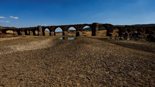
The Guadiana, Spain
River Po, Italy, August 2022
The Rhine, Germany
The Loire, France
1/4
The Guadiana, Spain - © picture alliance

What can be done?

Unfavourable forecasts over the coming months across Europe may compromise water supply and keep competition for this resource high.

The UK Centre for Ecology and Hydrology for example, suggest that sufficient rainfall may not occur until autumn. This means water resource management will be crucial over the coming months, to ensure a sustainable supply of good quality water.

Privacy Policy

Whilst drought mitigation strategies are of utmost importance now, so is addressing the root cause of the problem: climate change and the disruption of the planet's water cycle.

Further efforts are also needed to adapt to changing weather patterns, by protecting the climate of energy supply and applying sustainable solutions in agriculture, says the EU's Joint Research Centre.

Weather & Radar editorial team

More on the topic

Frosty nights on the horizon in Europe. Cold autumn air. . . Tuesday, 3 November 2026
Temperature forecast for Friday in Central Europe. The blue areas indicate freezing temperatures, particularly from eastern Germany through the Czech Republic to Austria.
Tuesday, 3 November 2026

Cold autumn air

Frosty nights on the horizon in Europe
Wetter but warmer, sunnier October. Monthly weather review. . . Tuesday, 3 November 2026
Split image showing two people sheltering under a blue umbrella in rain and a weather map with widespread rain across Britain and temperatures of 9–16°C.
Tuesday, 3 November 2026

Monthly weather review

Wetter but warmer, sunnier October
Heavy rain again in the south of France. Another bout of disruption. . . Wednesday, 4 November 2026
Split image showing heavy rain and lightning near Montpellier, Marseille and Monaco on a weather map, alongside cars stranded on a flooded road.
Wednesday, 4 November 2026

Another bout of disruption

Heavy rain again in the south of France
All weather news

This might also interest you

Super Typhoon Bavi threatens Taiwan. Up to 1,000 mm of rain. . . Wednesday, 8 July 2026
The image shows an intense tropical cyclone over the western Pacific, east of Taiwan and the Philippines. The centre of the system is depicted as a light purple and white vortex with a clearly visible eye, surrounded by a ring of red and orange areas indicating the strongest wind speeds. A white arrow marks the typhoon’s predicted track towards the north-west, in the direction of Taiwan. To the west of the storm lie the Philippines, with the cities of Manila and Cebu; to the north of these lies Taiwan, with Taipei. Further west, the Chinese coast, including Hong Kong, and parts of Vietnam can be seen. The coloured wind map shows predominantly green areas outside the storm’s core, indicating significantly weaker winds. White streamlines illustrate the typhoon’s anti-clockwise circulation in the Northern Hemisphere. The highest wind speeds are concentrated around the eye of the cyclone.
Wednesday, 8 July 2026

Up to 1,000 mm of rain

Super Typhoon Bavi threatens Taiwan
A stormy week in the skies above. Your weather - Your shots. . . Sunday, 30 August 2026
Split image showing lightning branching beneath dark storm clouds above rooftops on the left and an orange-pink sunset over a calm sea on the right.
Sunday, 30 August 2026

Your weather - Your shots

A stormy week in the skies above
Storm Chandra makes impact. Severe gales & heavy rain. . . Tuesday, 27 January 2026
Split image showing strong winds over the UK on a forecast map and widespread rain and snow on a weather radar map.
Tuesday, 27 January 2026

Severe gales & heavy rain

Storm Chandra makes impact
All articles
Weather & Radar

Weather & Radar is also available on

Google Play StoreApp Store

Company

Contact us Privacy Policy Legal info Accessibility statement

Services

Uploader

Socials

facebooktwittertikToklinkList