Home
Weather London
WeatherRadar
RainfallRadar
TemperatureRadar
WindRadar
LightningRadar
Weather News
Editor's Pick
Discover the app
Weather widget
Contact us
Apps
Career
    Home / Editor's Pick /

    Extreme danger: Forest fires are raging in southern Europe

12:07
6 July 2026

Drought and wind
Forest fires rage in southern Europe

Severe forest fires have spread across several southern European countries. From Portugal through Spain and the south of France to Greece.

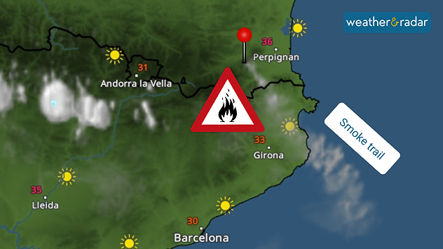
Thousands of firefighters are working to bring the blazes under control. In the French Pyrenees, emergency services are battling the flames across more than 4,600 hectares of difficult-to-access terrain.

So far, 10,000 people have had to be evacuated from several villages. The third stage of the Tour de France has also been affected and, for safety reasons, will take place without spectators.

The plume of smoke from the fire south-west of Perpignan can also be seen on the WeatherRadar.

Seven departments in south-eastern France are on the highest alert level, red, as of Monday. There have also been a number of fires in Portugal, Spain and Greece over the last few days.

Wind as an accelerator

As well as the dry conditions, strong winds are currently the main factor fuelling the spread of the fires. Strong gusts are also expected in many regions of southern Europe over the coming days.

Did you know?

Forest fires around the Mediterranean are not uncommon during dry summers. Around 90 per cent are caused by human activity. Climate change is extending the forest fire season and making vegetation more flammable.

Clemens Teutsch-Zumtobel
More on the topic
Europe's summer set to to break records. Extreme heat and drought. . . Tuesday, 11 August 2026
Split image showing a European heat map with temperatures reaching 39°C in France and Spain on the left, and a severely depleted river with exposed sandy banks beneath a bridge on the right.
Tuesday, 11 August 2026

Extreme heat and drought

Europe's summer set to to break records
More comfortable night's sleep. Overnight low drops. . . Wednesday, 5 August 2026
Morning temperature map of the UK and Ireland showing cool conditions, with temperatures ranging from 7°C in South Wales to 13°C in southeast England. Ireland records 9–12°C, while much of England and Wales is between 8°C and 10°C. A blue thermometer icon highlights the cooler weather.
Wednesday, 5 August 2026

Overnight low drops

More comfortable night's sleep
Solar eclipse on Wednesday. Save the date. . . Monday, 10 August 2026
People are watching a solar eclipse. The sun is already partially obscured. Next to it is the weather radar forecast for Wednesday, showing an almost cloudless sky.
Monday, 10 August 2026

Save the date

Solar eclipse on Wednesday
All weather news
This might also interest you
Flooding, gales, and heavy snow. Storm Chandra. . . Tuesday, 27 January 2026
Split image showing aerial flooding in a town with muddy water covering roads on the left, and a rural road on the right blocked by heavy snowfall with vans stopped and a person walking in snow.
Tuesday, 27 January 2026

Storm Chandra

Flooding, gales, and heavy snow
Bright and warm conditions take hold. Spring-like outlook. . . Thursday, 23 April 2026
Split UK map showing warm temperatures up to 21 degrees in orange on the left and clear sunny conditions with temperatures from 12 to 18 degrees on the right, with sun icons across the country.
Thursday, 23 April 2026

Spring-like outlook

Bright and warm conditions take hold
Super Typhoon Bavi threatens Taiwan. Up to 1,000 mm of rain. . . Wednesday, 8 July 2026
The image shows an intense tropical cyclone over the western Pacific, east of Taiwan and the Philippines. The centre of the system is depicted as a light purple and white vortex with a clearly visible eye, surrounded by a ring of red and orange areas indicating the strongest wind speeds. A white arrow marks the typhoon’s predicted track towards the north-west, in the direction of Taiwan. To the west of the storm lie the Philippines, with the cities of Manila and Cebu; to the north of these lies Taiwan, with Taipei. Further west, the Chinese coast, including Hong Kong, and parts of Vietnam can be seen. The coloured wind map shows predominantly green areas outside the storm’s core, indicating significantly weaker winds. White streamlines illustrate the typhoon’s anti-clockwise circulation in the Northern Hemisphere. The highest wind speeds are concentrated around the eye of the cyclone.
Wednesday, 8 July 2026

Up to 1,000 mm of rain

Super Typhoon Bavi threatens Taiwan
All articles
Weather & Radar

Weather & Radar is also available on

Google Play StoreApp Store

Company

Contact us Privacy Policy Legal info Accessibility statement

Services

Uploader

Socials

facebooktwittertikToklinkList