Home
Weather London
WeatherRadar
RainfallRadar
TemperatureRadar
WindRadar
LightningRadar
Weather News
Editor's Pick
Discover the app
Weather widget
Contact us
Apps
Career
    Home / Editor's Pick /

    Extreme cyclone heads to north Australia – hurricane-force gusts up to 177 mph

11:00
19 March 2026

Gusts of up to 177 mph
Extreme cyclone heads to north Australia

A dangerous tropical storm is brewing off the north-east coast of Australia: Narelle has intensified into a Category 5 cyclone and is heading towards Queensland.

On Friday morning (local time), the storm is set to make landfall with gusts exceeding 155 mph (250 km/h).

Did you know?

A Category 5 tropical storm causes extreme damage to buildings and infrastructure. A cyclone of this intensity strikes northern Australia only very rarely. 

Average wind speeds of around 124 mph (200 km/h) and hurricane-force gusts of up to 177 mph (285 km/h) have already been recorded over the sea. A tropical storm of this intensity has not been observed in the region for more than 100 years.

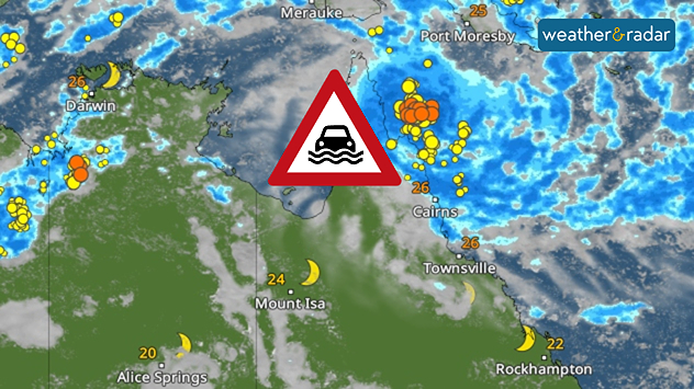
The region between Lockhart River and Cape Melville, north of the city of Cairns, is particularly affected. In addition to extreme winds, there is a risk of heavy rain and flash floods. As a result, widespread flooding is expected.

WeatherRadar: Heavy rain and thunderstorms are increasing the risk of flash floods, particularly in the region north of Cairns.

Schools have been closed and people are seeking shelter. There is a risk of power cuts and damage to infrastructure. However, the area is sparsely populated. The neighbouring Northern Territory is also preparing for the cyclone.

Tropical storm moves further westWeatherRadar Australia
Tommy Kühnlein
More on the topic
New heatwave in southern Europe. Up to 45 degrees in Spain. . . Tuesday, 21 July 2026
Split temperature map showing extreme heat across Spain on the left and Greece on the right, with temperatures reaching 44°C near Murcia, around 40°C in parts of Greece, and a large thermometer icon highlighting dangerous heat.
Tuesday, 21 July 2026

Up to 45 degrees in Spain

New heatwave in southern Europe
Heat becoming a bigger factor in drought. New study. . . Thursday, 23 July 2026
A hand holds dry, dusty earth above a parched field. The ground is cracked and covered with plant debris – a sign of prolonged drought.
Thursday, 23 July 2026

New study

Heat becoming a bigger factor in drought
Severe damage along the Adriatic coast. Huge hail and storms. . . Wednesday, 22 July 2026
Two hands are holding huge hailstones; next to them is a weather map showing thunderstorms and frequent lightning over the Adriatic coast and the western Balkans.
Wednesday, 22 July 2026

Huge hail and storms

Severe damage along the Adriatic coast
All weather news
This might also interest you
A frozen start to the weekend. Icy conditions. . . Friday, 13 February 2026
UK temperature map dated 14.02 showing widespread subzero values in blue shading, with readings such as −4 in Glasgow, −3 in Dublin, and −2 in London, alongside a blue thermometer icon.
Friday, 13 February 2026

Icy conditions

A frozen start to the weekend
Long-term trends need a pinch of salt. 40 °C in July?. . . Tuesday, 30 June 2026
Temperature radar of 2022 heatwave where the all-time temperature record in the UK was set. Warning symbol overlain.
Tuesday, 30 June 2026

40 °C in July?

Long-term trends need a pinch of salt
Turbulent weather in the Canary Islands. Storm and rain. . . Friday, 12 December 2025
Weather graphic showing rain and wind fields over the Canary Islands and a central warning symbol.
Friday, 12 December 2025

Storm and rain

Turbulent weather in the Canary Islands
All articles
Weather & Radar

Weather & Radar is also available on

Google Play StoreApp Store

Company

Contact us Privacy Policy Legal info Accessibility statement

Services

Uploader

Socials

facebooktwittertikToklinkList