Home
Weather London
WeatherRadar
RainfallRadar
TemperatureRadar
WindRadar
LightningRadar
Weather News
Editor's Pick
Discover the app
Weather widget
Contact us
Apps
Career
    Home / Editor's Pick /

    Extreme cyclone heads to north Australia – hurricane-force gusts up to 177 mph

11:00
19 March 2026

Gusts of up to 177 mph
Extreme cyclone heads to north Australia

A dangerous tropical storm is brewing off the north-east coast of Australia: Narelle has intensified into a Category 5 cyclone and is heading towards Queensland.

On Friday morning (local time), the storm is set to make landfall with gusts exceeding 155 mph (250 km/h).

Did you know?

A Category 5 tropical storm causes extreme damage to buildings and infrastructure. A cyclone of this intensity strikes northern Australia only very rarely. 

Average wind speeds of around 124 mph (200 km/h) and hurricane-force gusts of up to 177 mph (285 km/h) have already been recorded over the sea. A tropical storm of this intensity has not been observed in the region for more than 100 years.

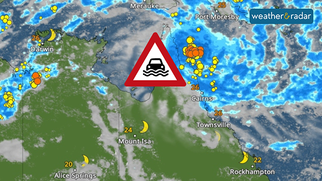
The region between Lockhart River and Cape Melville, north of the city of Cairns, is particularly affected. In addition to extreme winds, there is a risk of heavy rain and flash floods. As a result, widespread flooding is expected.

WeatherRadar: Heavy rain and thunderstorms are increasing the risk of flash floods, particularly in the region north of Cairns.

Schools have been closed and people are seeking shelter. There is a risk of power cuts and damage to infrastructure. However, the area is sparsely populated. The neighbouring Northern Territory is also preparing for the cyclone.

Tropical storm moves further westWeatherRadar Australia
Tommy Kühnlein
More on the topic
Split image showing a bright rainbow above a residential street on the left and a dramatic ocean sunrise with glowing clouds and reflections on the sea on the right.
Sunday, 24 May 2026

Your weather - Your shots

From unsettled to warm and toasty
Temperature map of southeast England showing overnight low temperatures, with Kenley highlighted at 21.3°C and surrounding areas in yellow-orange shades indicating mild nighttime conditions.
Tuesday, 26 May 2026

May heatwave

Tropical night breaks overnight record
Nighttime marina with sailboats and glowing harbor lights beneath electric-blue noctilucent clouds stretching across the dark twilight sky.
Saturday, 23 May 2026

A silvery haze in the sky

The season of the luminous night clouds
All weather news
This might also interest you
Illustration of white and yellow fireworks on a blue background.
Wednesday, 31 December 2025

Hello 2026

Happy New Year
UK temperature map dated 14.02 showing widespread subzero values in blue shading, with readings such as −4 in Glasgow, −3 in Dublin, and −2 in London, alongside a blue thermometer icon.
Friday, 13 February 2026

Icy conditions

A frozen start to the weekend
plit image showing a double rainbow over a rocky shoreline on the left and sheep grazing in a green field under stormy clouds on the right.
Sunday, 2 November 2025

Your weather - Your shots

Mixed conditions on an unsettled week
All articles
Weather & Radar

Weather & Radar is also available on

Google Play StoreApp Store

Company

Contact us Privacy Policy Legal info Accessibility statement

Services

Uploader

Socials

facebooktwittertikToklinkList