Home
Weather London
WeatherRadar
RainfallRadar
TemperatureRadar
WindRadar
LightningRadar
Weather News
Editor's Pick
Discover the app
Weather widget
Contact us
Apps
Career
    Home / Editor's Pick /

    Early summer ends - A change in the weather is on the way

12:01
27 May 2026

Early summer ends
A change in the weather is on the way

For days now, a powerful summer high-pressure system has had large parts of western and central Europe firmly in its grip, prompting heatwaves.

There are now signs that the hot, dry weather will come to an end this weekend.

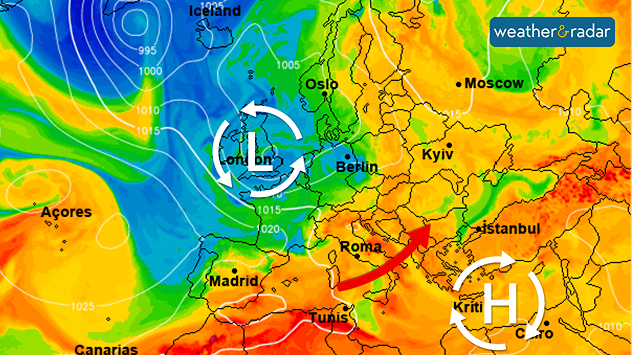
The wind will shift to a south-westerly direction, bringing significantly more humid air. This will give rise to the first heavy summer thunderstorms in Europe. Severe weather is also expected in some areas, particularly on Sunday. Afterwards, temperatures will drop noticeably.

In the first few days of June, the low-pressure system will gradually shift from the Atlantic towards the UK and Ireland.

The leading weather models are forecasting a return to typical westerly weather conditions in early June for the first time in quite a while. This means that Atlantic lows will be moving from west to east towards Europe, bringing with them rain and a mix of cool and slightly warmer air.

In southern Europe, things remain much the same: the hot summer weather persists there. Although there are increasing numbers of heat-induced thunderstorms over the mountainous regions of Spain, Italy, and the Balkans, they do not bring any real relief from the heat.

Keep an eye on the weather at all timesWeatherRadar
Weather & Radar editorial team
More on the topic
Poor harvest expected after drought. Rain remains scarce. . . Thursday, 6 August 2026
Split image showing an aerial view of drought-stricken parkland with dry yellow-brown grass surrounding a church on the left, and a temperature map of England and Wales on the right with temperatures reaching 30°C in southeast England.
Thursday, 6 August 2026

Rain remains scarce

Poor harvest expected after drought
The Perseids reach their peak. Shooting stars overhead. . . Tuesday, 11 August 2026
Shooting stars in the night sky
Tuesday, 11 August 2026

Shooting stars overhead

The Perseids reach their peak
More comfortable night's sleep. Overnight low drops. . . Wednesday, 5 August 2026
Morning temperature map of the UK and Ireland showing cool conditions, with temperatures ranging from 7°C in South Wales to 13°C in southeast England. Ireland records 9–12°C, while much of England and Wales is between 8°C and 10°C. A blue thermometer icon highlights the cooler weather.
Wednesday, 5 August 2026

Overnight low drops

More comfortable night's sleep
All weather news
This might also interest you
Super Typhoon Bavi threatens Taiwan. Up to 1,000 mm of rain. . . Wednesday, 8 July 2026
The image shows an intense tropical cyclone over the western Pacific, east of Taiwan and the Philippines. The centre of the system is depicted as a light purple and white vortex with a clearly visible eye, surrounded by a ring of red and orange areas indicating the strongest wind speeds. A white arrow marks the typhoon’s predicted track towards the north-west, in the direction of Taiwan. To the west of the storm lie the Philippines, with the cities of Manila and Cebu; to the north of these lies Taiwan, with Taipei. Further west, the Chinese coast, including Hong Kong, and parts of Vietnam can be seen. The coloured wind map shows predominantly green areas outside the storm’s core, indicating significantly weaker winds. White streamlines illustrate the typhoon’s anti-clockwise circulation in the Northern Hemisphere. The highest wind speeds are concentrated around the eye of the cyclone.
Wednesday, 8 July 2026

Up to 1,000 mm of rain

Super Typhoon Bavi threatens Taiwan
Turbulent weather in the Canary Islands. Storm and rain. . . Friday, 12 December 2025
Weather graphic showing rain and wind fields over the Canary Islands and a central warning symbol.
Friday, 12 December 2025

Storm and rain

Turbulent weather in the Canary Islands
Flooding, gales, and heavy snow. Storm Chandra. . . Tuesday, 27 January 2026
Split image showing aerial flooding in a town with muddy water covering roads on the left, and a rural road on the right blocked by heavy snowfall with vans stopped and a person walking in snow.
Tuesday, 27 January 2026

Storm Chandra

Flooding, gales, and heavy snow
All articles
Weather & Radar

Weather & Radar is also available on

Google Play StoreApp Store

Company

Contact us Privacy Policy Legal info Accessibility statement

Services

Uploader

Socials

facebooktwittertikToklinkList