Home
Weather London
WeatherRadar
RainfallRadar
TemperatureRadar
WindRadar
LightningRadar
Weather News
Editor's Pick
Discover the app
Weather widget
Contact us
Apps
Career
    Home / Editor's Pick /

    Early summer ends - A change in the weather is on the way

12:01
27 May 2026

Early summer ends
A change in the weather is on the way

For days now, a powerful summer high-pressure system has had large parts of western and central Europe firmly in its grip, prompting heatwaves.

There are now signs that the hot, dry weather will come to an end this weekend.

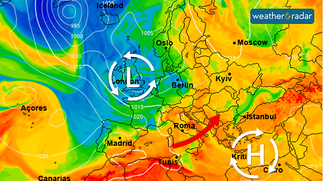
The wind will shift to a south-westerly direction, bringing significantly more humid air. This will give rise to the first heavy summer thunderstorms in Europe. Severe weather is also expected in some areas, particularly on Sunday. Afterwards, temperatures will drop noticeably.

In the first few days of June, the low-pressure system will gradually shift from the Atlantic towards the UK and Ireland.

The leading weather models are forecasting a return to typical westerly weather conditions in early June for the first time in quite a while. This means that Atlantic lows will be moving from west to east towards Europe, bringing with them rain and a mix of cool and slightly warmer air.

In southern Europe, things remain much the same: the hot summer weather persists there. Although there are increasing numbers of heat-induced thunderstorms over the mountainous regions of Spain, Italy, and the Balkans, they do not bring any real relief from the heat.

Keep an eye on the weather at all timesWeatherRadar
Weather & Radar editorial team
More on the topic
Hottest summer on record for Ireland. Beating 2025's record. . . Thursday, 3 September 2026
Temperature map of Ireland showing 29°C in Dublin, 26°C in Cork, 24°C in Belfast, and 23°C in Galway, with a red thermometer icon.
Thursday, 3 September 2026

Beating 2025's record

Hottest summer on record for Ireland
A generally gusty Thursday. Moderate but notable wind. . . Wednesday, 2 September 2026
Wind forecast showing widespread 25-30 mph winds across the UK and Ireland, including Glasgow, Dublin, Cork, Cardiff, and London, with a windsock symbol.
Wednesday, 2 September 2026

Moderate but notable wind

A generally gusty Thursday
Cheshire Gap produces shower funnel. Local phenomenon. . . Wednesday, 9 September 2026
Weather map showing showers moving southeast from Liverpool toward Birmingham, driven by Cheshire Gap convergence across central England.
Wednesday, 9 September 2026

Local phenomenon

Cheshire Gap produces shower funnel
All weather news
This might also interest you
New records for England and Wales. Broken again tomorrow?. . . Thursday, 25 June 2026
Temperature map of southwest Britain on 25.06 showing extreme heat across southern Wales and southwest England, with Bute Park in Cardiff highlighted at 34.2°C and Yeovilton at 36.4°C amid widespread deep red heat zones.
Thursday, 25 June 2026

Broken again tomorrow?

New records for England and Wales
Long-term trends need a pinch of salt. 40 °C in July?. . . Tuesday, 30 June 2026
Temperature radar of 2022 heatwave where the all-time temperature record in the UK was set. Warning symbol overlain.
Tuesday, 30 June 2026

40 °C in July?

Long-term trends need a pinch of salt
A stormy week in the skies above. Your weather - Your shots. . . Sunday, 30 August 2026
Split image showing lightning branching beneath dark storm clouds above rooftops on the left and an orange-pink sunset over a calm sea on the right.
Sunday, 30 August 2026

Your weather - Your shots

A stormy week in the skies above
All articles
Weather & Radar

Weather & Radar is also available on

Google Play StoreApp Store

Company

Contact us Privacy Policy Legal info Accessibility statement

Services

Uploader

Socials

facebooktwittertikToklinkList