Home
Weather London
WeatherRadar
RainfallRadar
TemperatureRadar
WindRadar
LightningRadar
Weather News
Editor's Pick
Discover the app
Weather widget
Contact us
Apps
Career
    Home / Editor's Pick /

    Early summer ends - A change in the weather is on the way

12:01
27 May 2026

Early summer ends
A change in the weather is on the way

For days now, a powerful summer high-pressure system has had large parts of western and central Europe firmly in its grip, prompting heatwaves.

There are now signs that the hot, dry weather will come to an end this weekend.

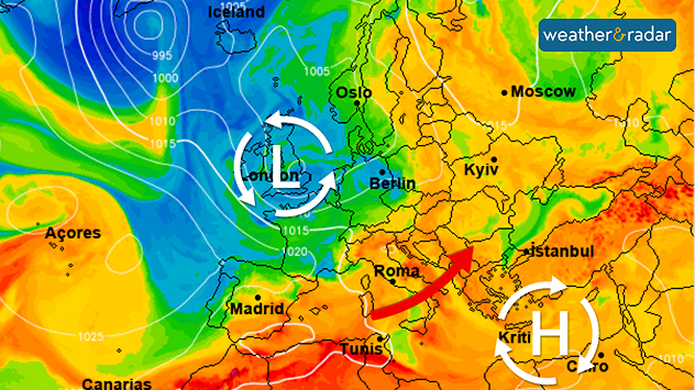
The wind will shift to a south-westerly direction, bringing significantly more humid air. This will give rise to the first heavy summer thunderstorms in Europe. Severe weather is also expected in some areas, particularly on Sunday. Afterwards, temperatures will drop noticeably.

In the first few days of June, the low-pressure system will gradually shift from the Atlantic towards the UK and Ireland.

The leading weather models are forecasting a return to typical westerly weather conditions in early June for the first time in quite a while. This means that Atlantic lows will be moving from west to east towards Europe, bringing with them rain and a mix of cool and slightly warmer air.

In southern Europe, things remain much the same: the hot summer weather persists there. Although there are increasing numbers of heat-induced thunderstorms over the mountainous regions of Spain, Italy, and the Balkans, they do not bring any real relief from the heat.

Keep an eye on the weather at all timesWeatherRadar
Weather & Radar editorial team
More on the topic
Summer in full flow. Your weather - Your shots. . . Sunday, 5 July 2026
Split image showing golden crepuscular rays streaming through sunset clouds over the countryside on the left, and glowing blue noctilucent clouds above silhouetted trees and traffic lights at twilight on the right.
Sunday, 5 July 2026

Your weather - Your shots

Summer in full flow
Forest fires rage in southern Europe. Drought and wind. . . Monday, 6 July 2026
Split screen. On the left, a weather map of France and Spain showing the plumes of smoke from the forest fires. On the right, a fire-fighting aircraft in action.
Monday, 6 July 2026

Drought and wind

Forest fires rage in southern Europe
Lee waves flow over the UK and Ireland. On the WeatherRadar. . . Monday, 6 July 2026
Satellite weather map of the UK and Ireland showing parallel bands of low cloud highlighted over southern Scotland and northern England, with additional cloud streets over Wales and western England circled in white.
Monday, 6 July 2026

On the WeatherRadar

Lee waves flow over the UK and Ireland
All weather news
This might also interest you
Historic Storm Éowyn arrives. On this day.... . . Saturday, 24 January 2026
Split image showing a person in a yellow jacket struggling against strong winds and heavy rain on a street at night on the left, and an Irish wind forecast map on the right with red and purple shading, gusts up to 75 mph, and a wind warning icon, divided by a curved white line.
Saturday, 24 January 2026

On this day...

Historic Storm Éowyn arrives
Seasonal warmth between spring thunder. Your weather - Your shots. . . Sunday, 19 April 2026
Split image showing coastal sunset with layered lenticular clouds over rooftops and palm trees on the left, and a green valley with river and hills under soft daylight on the right.
Sunday, 19 April 2026

Your weather - Your shots

Seasonal warmth between spring thunder
A frozen start to the weekend. Icy conditions. . . Friday, 13 February 2026
UK temperature map dated 14.02 showing widespread subzero values in blue shading, with readings such as −4 in Glasgow, −3 in Dublin, and −2 in London, alongside a blue thermometer icon.
Friday, 13 February 2026

Icy conditions

A frozen start to the weekend
All articles
Weather & Radar

Weather & Radar is also available on

Google Play StoreApp Store

Company

Contact us Privacy Policy Legal info Accessibility statement

Services

Uploader

Socials

facebooktwittertikToklinkList