Home
Weather London
WeatherRadar
RainfallRadar
TemperatureRadar
WindRadar
LightningRadar
Weather News
Editor's Pick
Discover the app
Weather widget
Contact us
Apps
Career
    Home / Editor's Pick /

    Dry start, then showers - Rain builds again through the day

09:30
14 May 2026

Dry start, then showers
Rain builds again through the day

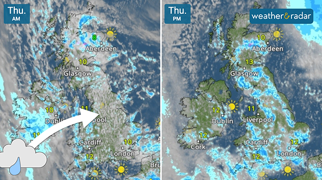
Split satellite weather map of the UK for Thursday AM and Thursday PM, showing morning cloud and rain bands followed by brighter afternoon conditions with sunny intervals across the UK and Ireland.
Early rain in Ireland moves into the UK later on Thursday.

Patchy cloud with peeks of blue sky started the day in parts of the UK, but it is deceiving. After a rainy morning in Ireland, the showers shift east for the afternoon.

Conditions are much alike Wednesday, with showers rolling through the UK Thursday afternoon. Some of these have potential to turn heavy, perhaps with hail, especially to the south-west, south, and east of England.

There is also still a risk of some turning thundery later in the day, abruptly changing any outdoor plans you may have with stiff gusts in tow.

In Ireland, the opposite conditions are forecast. After prolonged rainfall in the west in the morning, the rain gradually eases for a drier afternoon.

To the east and south of the country, more stubborn rain is liable to stick around before clear skies arrive for the evening.

Track incoming showers on the WeatherRadar throughout the day, and remember to keep an eye out for yellow dots in the "Now" section to follow lightning strikes as they happen.

Ryan Hathaway
More on the topic
A generally gusty Thursday. Moderate but notable wind. . . Wednesday, 2 September 2026
Wind forecast showing widespread 25-30 mph winds across the UK and Ireland, including Glasgow, Dublin, Cork, Cardiff, and London, with a windsock symbol.
Wednesday, 2 September 2026

Moderate but notable wind

A generally gusty Thursday
Cheshire Gap produces shower funnel. Local phenomenon. . . Wednesday, 9 September 2026
Weather map showing showers moving southeast from Liverpool toward Birmingham, driven by Cheshire Gap convergence across central England.
Wednesday, 9 September 2026

Local phenomenon

Cheshire Gap produces shower funnel
Warm waters raise severe weather risk. Mediterranean bathtub. . . Friday, 4 September 2026
Left: Map showing water temperatures in the Mediterranean; Right: Dark clouds over a stretch of Mediterranean coastline. A bolt of lightning strikes and a curtain of rain can be seen.
Friday, 4 September 2026

Mediterranean bathtub

Warm waters raise severe weather risk
All weather news
This might also interest you
New records for England and Wales. Broken again tomorrow?. . . Thursday, 25 June 2026
Temperature map of southwest Britain on 25.06 showing extreme heat across southern Wales and southwest England, with Bute Park in Cardiff highlighted at 34.2°C and Yeovilton at 36.4°C amid widespread deep red heat zones.
Thursday, 25 June 2026

Broken again tomorrow?

New records for England and Wales
Storm Chandra makes impact. Severe gales & heavy rain. . . Tuesday, 27 January 2026
Split image showing strong winds over the UK on a forecast map and widespread rain and snow on a weather radar map.
Tuesday, 27 January 2026

Severe gales & heavy rain

Storm Chandra makes impact
A stormy week in the skies above. Your weather - Your shots. . . Sunday, 30 August 2026
Split image showing lightning branching beneath dark storm clouds above rooftops on the left and an orange-pink sunset over a calm sea on the right.
Sunday, 30 August 2026

Your weather - Your shots

A stormy week in the skies above
All articles
Weather & Radar

Weather & Radar is also available on

Google Play StoreApp Store

Company

Contact us Privacy Policy Legal info Accessibility statement

Services

Uploader

Socials

facebooktwittertikToklinkList