Home
Weather London
WeatherRadar
RainfallRadar
TemperatureRadar
WindRadar
LightningRadar
Weather News
Editor's Pick
Discover the app
Weather widget
Contact us
Apps
Career
    Home / Editor's Pick /

    Drought brings flash flood risks as rain returns

08:57
19 August 2026

As rain returns
Drought brings flash flood risks

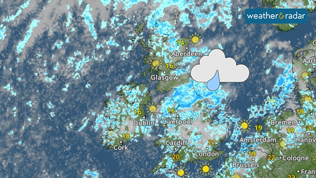
Weather radar map of the UK and Ireland showing widespread showers and rain, especially across England, with brighter spells in Scotland and southern England.
A much wetter look on the WeatherRadar come Thursday than we've become used to.

Many parts of England are set to see the first widespread rainfall in over a month this week, a return that could result in flooding while still in an official drought.

Showers are becoming more visible from Wednesday, with heavier and potentially thundery outbursts, on Thursday. These pass through many regions under a drought declaration and water use restrictions.

After months of unusually hot and dry conditions, the ground soil will not be able to efficiently absorb this rainfall. Instead, the baked and parched ground will allow the water to collect, possibly leading to flash floods in some areas.

A return of showers is also not going to meaningfully improve the drought situation any time soon.

Currently, 71% of England is in drought according to the Environment Agency, with taps running dry in parts of Kent while Wisley, Surrey has just seen the first rain in 62 days.

To sufficiently recover ground moisture and reservoir levels, which as of August 13th were resting at 65% of capacity, more sustained rainfall is needed.

In the meantime, the risk of flash floods will persist where coming showers turn heavy. Keep one eye on the WeatherRadar to see when they reach your area.

Ryan Hathaway
More on the topic
First taste of winter in the Alps. White mountain peaks. . . Friday, 25 September 2026
Winter scenery in the Alps along the Großglockner High Alpine Road
Friday, 25 September 2026

White mountain peaks

First taste of winter in the Alps
Hurricane threat off the coast of Mexico. Storm and rain. . . Monday, 21 September 2026
Split image showing a powerful tropical system southwest of Acapulco on a wind map and palm trees bending sharply in strong winds.
Monday, 21 September 2026

Storm and rain

Hurricane threat off the coast of Mexico
Low delivers days of gusty conditions. Into the weekend. . . Thursday, 17 September 2026
Wind map showing low pressure near the Faroe Islands, with winds reaching 35 mph around Aberdeen and Dublin and stronger Atlantic winds west of the UK.
Thursday, 17 September 2026

Into the weekend

Low delivers days of gusty conditions
All weather news
This might also interest you
A frozen start to the weekend. Icy conditions. . . Friday, 13 February 2026
UK temperature map dated 14.02 showing widespread subzero values in blue shading, with readings such as −4 in Glasgow, −3 in Dublin, and −2 in London, alongside a blue thermometer icon.
Friday, 13 February 2026

Icy conditions

A frozen start to the weekend
Long-term trends need a pinch of salt. 40 °C in July?. . . Tuesday, 30 June 2026
Temperature radar of 2022 heatwave where the all-time temperature record in the UK was set. Warning symbol overlain.
Tuesday, 30 June 2026

40 °C in July?

Long-term trends need a pinch of salt
A stormy week in the skies above. Your weather - Your shots. . . Sunday, 30 August 2026
Split image showing lightning branching beneath dark storm clouds above rooftops on the left and an orange-pink sunset over a calm sea on the right.
Sunday, 30 August 2026

Your weather - Your shots

A stormy week in the skies above
All articles
Weather & Radar

Weather & Radar is also available on

Google Play StoreApp Store

Company

Contact us Privacy Policy Legal info Accessibility statement

Services

Uploader

Socials

facebooktwittertikToklinkList