Home
Weather London
WeatherRadar
RainfallRadar
TemperatureRadar
WindRadar
LightningRadar
Weather News
Editor's Pick
Discover the app
Weather widget
Contact us
Apps
Career
    Home / Editor's Pick /

    Down to single digits - Cooler morning for eastern Scotland

15:30
29 July 2025

Down to single digits
Cooler morning for eastern Scotland

Anyone up early will enjoy a cooler start to the day.

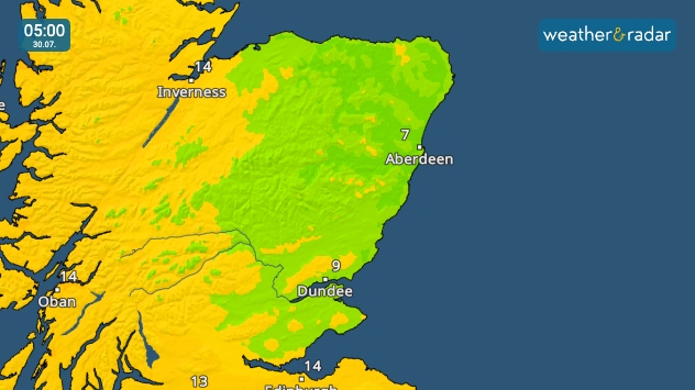
There is a dip back down to single-digit temperatures for the early risers on Wednesday in parts of eastern Scotland.

With a low of 7 - 9 °C, it's a sight not seen in recent summer weeks, but also one that does not last long.

By the afternoon, Dundee reaches a high of around 22 °C while the coolest area around Aberdeen reaches the upper teens.

Check the TempereatureRadar
Ryan Hathaway
More on the topic
Severe weather spreads across Europe. Lightning, hail, gales. . . Wednesday, 15 July 2026
Split image showing a dramatic supercell thunderstorm with dark rotating clouds over open countryside on the left, and a severe thunderstorm warning map on the right highlightning elevated storm risk across parts of central Europe, including northern Italy, Switzerland, eastern France, and southern Germany.
Wednesday, 15 July 2026

Lightning, hail, gales

Severe weather spreads across Europe
Sea fog rolls into Pembrokeshire. Unique summer scene. . . Tuesday, 14 July 2026
Thick sea fog rolling inland over a sunlit bay, with sparkling water, trees and garden in the foreground, and a hill rising above the fog under a clear blue sky.
Tuesday, 14 July 2026

Unique summer scene

Sea fog rolls into Pembrokeshire
Wildfires break out amid ongoing drought. Water restrictions active. . . Tuesday, 14 July 2026
Smoke rising from a scorched moorland hillside after a wildfire, with blackened vegetation, smouldering ground, and drifting gray smoke covering the burned landscape.
Tuesday, 14 July 2026

Water restrictions active

Wildfires break out amid ongoing drought
All weather news
This might also interest you
Super Typhoon Bavi threatens Taiwan. Up to 1,000 mm of rain. . . Wednesday, 8 July 2026
The image shows an intense tropical cyclone over the western Pacific, east of Taiwan and the Philippines. The centre of the system is depicted as a light purple and white vortex with a clearly visible eye, surrounded by a ring of red and orange areas indicating the strongest wind speeds. A white arrow marks the typhoon’s predicted track towards the north-west, in the direction of Taiwan. To the west of the storm lie the Philippines, with the cities of Manila and Cebu; to the north of these lies Taiwan, with Taipei. Further west, the Chinese coast, including Hong Kong, and parts of Vietnam can be seen. The coloured wind map shows predominantly green areas outside the storm’s core, indicating significantly weaker winds. White streamlines illustrate the typhoon’s anti-clockwise circulation in the Northern Hemisphere. The highest wind speeds are concentrated around the eye of the cyclone.
Wednesday, 8 July 2026

Up to 1,000 mm of rain

Super Typhoon Bavi threatens Taiwan
A frozen start to the weekend. Icy conditions. . . Friday, 13 February 2026
UK temperature map dated 14.02 showing widespread subzero values in blue shading, with readings such as −4 in Glasgow, −3 in Dublin, and −2 in London, alongside a blue thermometer icon.
Friday, 13 February 2026

Icy conditions

A frozen start to the weekend
Storm Chandra makes impact. Severe gales & heavy rain. . . Tuesday, 27 January 2026
Split image showing strong winds over the UK on a forecast map and widespread rain and snow on a weather radar map.
Tuesday, 27 January 2026

Severe gales & heavy rain

Storm Chandra makes impact
All articles
Weather & Radar

Weather & Radar is also available on

Google Play StoreApp Store

Company

Contact us Privacy Policy Legal info Accessibility statement

Services

Uploader

Socials

facebooktwittertikToklinkList