Home
Weather London
WeatherRadar
RainfallRadar
TemperatureRadar
WindRadar
LightningRadar
Weather News
Editor's Pick
Discover the app
Weather widget
Contact us
Apps
Career
    Home / Editor's Pick /

    Damage and fatalities: Typhoon RAGASA wreaks havoc in Southeast Asia

09:40
24 September 2025

Damage and fatalities
Typhoon RAGASA rages in Southeast Asia

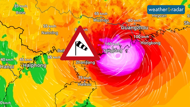
WindRadar shows wind speeds exceeding 150 kilometres per hour on the coast of China
WindRadar: Typhoon RAGASA hits the south coast of China with wind speeds between 150 and 200 kilometres per hour.

Super Typhoon RAGASA has now reached Hong Kong and China in Southeast Asia, bringing with it strong winds and heavy rainfall. It had previously caused severe damage in the Philippines and Taiwan, claiming the lives of over 20 people.

There, it made landfall with wind speeds of over 200 kilometres per hour in some areas. High waves caused flooding along the coast.

Today, the cyclone is hitting southern China as a typhoon of the second-highest category. In the densely populated coastal province of Guangdong, more than a million people have been brought to safety since yesterday. In neighbouring Hong Kong, too, public life has largely come to a standstill.

The typhoon remains very dangerous because it will initially continue to move westward along the Chinese coast and only then slowly weaken over land.

Super Typhoon RAGASA continues to move onWindRadar
Dr. Bernd Maurer
More on the topic
Cheshire Gap produces shower funnel. Local phenomenon. . . Wednesday, 9 September 2026
Weather map showing showers moving southeast from Liverpool toward Birmingham, driven by Cheshire Gap convergence across central England.
Wednesday, 9 September 2026

Local phenomenon

Cheshire Gap produces shower funnel
Warm waters raise severe weather risk. Mediterranean bathtub. . . Friday, 4 September 2026
Left: Map showing water temperatures in the Mediterranean; Right: Dark clouds over a stretch of Mediterranean coastline. A bolt of lightning strikes and a curtain of rain can be seen.
Friday, 4 September 2026

Mediterranean bathtub

Warm waters raise severe weather risk
Hottest summer on record for Ireland. Beating 2025's record. . . Thursday, 3 September 2026
Temperature map of Ireland showing 29°C in Dublin, 26°C in Cork, 24°C in Belfast, and 23°C in Galway, with a red thermometer icon.
Thursday, 3 September 2026

Beating 2025's record

Hottest summer on record for Ireland
All weather news
This might also interest you
Storm Chandra makes impact. Severe gales & heavy rain. . . Tuesday, 27 January 2026
Split image showing strong winds over the UK on a forecast map and widespread rain and snow on a weather radar map.
Tuesday, 27 January 2026

Severe gales & heavy rain

Storm Chandra makes impact
Historic Storm Éowyn arrives. On this day.... . . Saturday, 24 January 2026
Split image showing a person in a yellow jacket struggling against strong winds and heavy rain on a street at night on the left, and an Irish wind forecast map on the right with red and purple shading, gusts up to 75 mph, and a wind warning icon, divided by a curved white line.
Saturday, 24 January 2026

On this day...

Historic Storm Éowyn arrives
A stormy week in the skies above. Your weather - Your shots. . . Sunday, 30 August 2026
Split image showing lightning branching beneath dark storm clouds above rooftops on the left and an orange-pink sunset over a calm sea on the right.
Sunday, 30 August 2026

Your weather - Your shots

A stormy week in the skies above
All articles
Weather & Radar

Weather & Radar is also available on

Google Play StoreApp Store

Company

Contact us Privacy Policy Legal info Accessibility statement

Services

Uploader

Socials

facebooktwittertikToklinkList