Home
Weather London
WeatherRadar
RainfallRadar
TemperatureRadar
WindRadar
LightningRadar
Weather News
Editor's Pick
Discover the app
Weather widget
Contact us
Apps
Career
    Home / Editor's Pick /

    Cyclones & earthquakes: A week of natural disasters in Vanuatu

10:30
3 March 2023

Cyclones & earthquakes
A week of natural disasters in Vanuatu

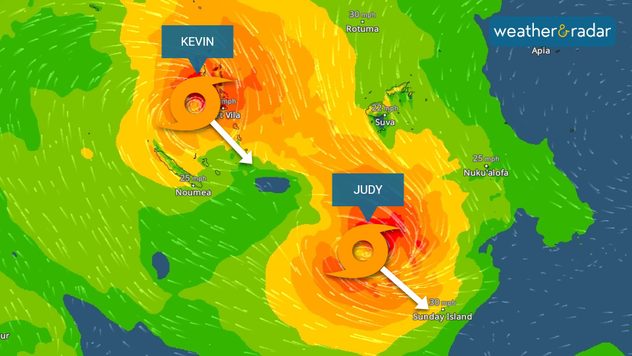
WindRadar showing two cyclones
Cyclones Judy and Kevin seen on the WindRadar this morning as Kevin reaches Vanuatu.

The Pacific island state of Vanuatu is feeling the impact of its second tropical cyclone in 24 hours amid earthquakes today.

From Tuesday Cyclone Judy arrived on the island east of Australia with gale force winds, heavy rain, and a storm surge which flooded coastal areas as winds approached 124 mph.

With winds at this level its force is comparable to a category 3 hurricane. Now, Cyclone Kevin has arrived on the scene.

The impact of Cyclone Judy.

At this time Kevin is delivering yet more gale force winds reaching 85 mph as the system passes island capital Port Vila.

The capital has already been damaged by Judy in recent days with both cyclones’ eyewall, the area around the eye of the cyclone where winds are strongest, reaching the city.

Fiji and New Caledonia have also felt the impact of these cyclones as they pass through the region.

Both cyclones are following almost exactly the same track through the Pacific, by Monday the two will have moved southeast towards open waters.

It is likely that the two cyclones are interacting with each other as Judy paves the way forward for Kevin behind.

Cyclones are not the only natural disaster on the island, earlier today two earthquakes also struck the island. Registering as magnitudes 6.5 and 5.4.

No casualties have been reported from the events though hundreds of people were evacuated ahead of the storms. A specialist team from Australia is travelling to assess the damage.

You can see the systems for yourself using the WindRadar.

Ryan Hathaway
More on the topic
Record ocean heat halting hurricanes. Strong El Niño influence. . . Friday, 11 September 2026
A weather map shows a calm Atlantic Ocean with no hurricanes, alongside a picture of the sea.
Friday, 11 September 2026

Strong El Niño influence

Record ocean heat halting hurricanes
Severe weather hits Mallorca and Italy. Severe thunderstorms. . . Thursday, 10 September 2026
Numerous thunderstorms are sweeping across La Palma. The many lightning symbols on the radar and lightning map show that there is heavy lightning activity across large parts of the island. The thunderstorms are striking particularly in the island’s interior and in the south. On the right, you can see the aftermath: a large fallen tree has buried a car beneath it. Emergency services are clearing up the damage. So, along with the thunderstorms, not only heavy rain but also gusts of wind can become a problem.
Thursday, 10 September 2026

Severe thunderstorms

Severe weather hits Mallorca and Italy
Hottest summer on record for Ireland. Beating 2025's record. . . Thursday, 3 September 2026
Temperature map of Ireland showing 29°C in Dublin, 26°C in Cork, 24°C in Belfast, and 23°C in Galway, with a red thermometer icon.
Thursday, 3 September 2026

Beating 2025's record

Hottest summer on record for Ireland
All weather news
This might also interest you
Flooding, gales, and heavy snow. Storm Chandra. . . Tuesday, 27 January 2026
Split image showing aerial flooding in a town with muddy water covering roads on the left, and a rural road on the right blocked by heavy snowfall with vans stopped and a person walking in snow.
Tuesday, 27 January 2026

Storm Chandra

Flooding, gales, and heavy snow
A frozen start to the weekend. Icy conditions. . . Friday, 13 February 2026
UK temperature map dated 14.02 showing widespread subzero values in blue shading, with readings such as −4 in Glasgow, −3 in Dublin, and −2 in London, alongside a blue thermometer icon.
Friday, 13 February 2026

Icy conditions

A frozen start to the weekend
Historic Storm Éowyn arrives. On this day.... . . Saturday, 24 January 2026
Split image showing a person in a yellow jacket struggling against strong winds and heavy rain on a street at night on the left, and an Irish wind forecast map on the right with red and purple shading, gusts up to 75 mph, and a wind warning icon, divided by a curved white line.
Saturday, 24 January 2026

On this day...

Historic Storm Éowyn arrives
All articles
Weather & Radar

Weather & Radar is also available on

Google Play StoreApp Store

Company

Contact us Privacy Policy Legal info Accessibility statement

Services

Uploader

Socials

facebooktwittertikToklinkList