Home
Weather London
WeatherRadar
RainfallRadar
TemperatureRadar
WindRadar
LightningRadar
Weather News
Editor's Pick
Discover the app
Weather widget
Contact us
Apps
Career
    Home / Editor's Pick /

    Cyclone Freddy: Longest lasting cyclone on record

09:00
9 March 2023

Cyclone Freddy
Longest lasting cyclone on record

Cyclone Freddy
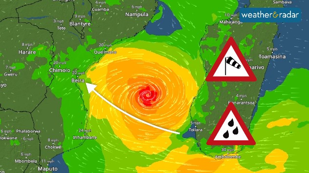
Cyclone Freddy, seen on the WindRadar, is currently approaching Mozambique for a second time.

Cyclone Freddy is set to make history as the world’s longest-lived cyclone after reaching 31 days of life.

Freddy formed on February 6th over the northwest coast of Australia and crossed the entire Indian Ocean on its advance to East Africa where it will soon return over Mozambique which has already received over 500 mm of rain.

As it crossed the ocean, the cyclone gained more strength as it first reached the islands of Mauritius and Réunion. Two weeks later it made landfall in Madagascar, where it began its destructive journey.

Freddy then moved over Mozambique before changing trajectory again turning towards Madagascar. It is still there now, causing a great deal of damage, particularly on the west coast.

Cyclone Freddy is currently moving very slowly across the Mozambique Channel, which is located between the mainland of Africa and the island of Madagascar.

Speed of a cyclone

Freddy is moving at just 10 mph resulting in large rainfall totals. Some systems can travel as fast as 40 mph.

The cyclone will now move over Mozambique and Zimbabwe for the second time, reaching their southeast coastline by Friday.

Record-breaker?

The longest-lasting cyclone in history, Hurricane John, lasted for 31 days although that system spent almost its entire life at sea.

On March 9th, Freddy will officially take the crown as the longest-lasting system on record. It is not the only record it has claimed.

Freddy has seen six bouts of intensification; this refers to the rapid rise in winds by 35 mph or greater within 24 hours. No storm in the Southern Hemisphere had intensified more than three times and just three storms in the Northern Hemisphere reached four.

Forecasts are not entirely clear due to the cyclone's great unpredictability so far, but the cyclone should dissipate definitively in the early hours of Monday, March 13, 2023.

Ryan Hathaway
More on the topic
v
Thursday, 28 May 2026

Gusts exceeding 124 mph

Typhoon risk in the Western Pacific
Temperature map of southeast England showing overnight low temperatures, with Kenley highlighted at 21.3°C and surrounding areas in yellow-orange shades indicating mild nighttime conditions.
Tuesday, 26 May 2026

May heatwave

Tropical night breaks overnight record
Split image showing a nighttime lightning strike beneath storm clouds on the left and a lightning detection map with dense storm activity across central England on the right.
Wednesday, 27 May 2026

Trickier than you think

Why it's hard to pinpoint thunderstorms
All weather news
This might also interest you
plit image showing a double rainbow over a rocky shoreline on the left and sheep grazing in a green field under stormy clouds on the right.
Sunday, 2 November 2025

Your weather - Your shots

Mixed conditions on an unsettled week
Illustration of white and yellow fireworks on a blue background.
Wednesday, 31 December 2025

Hello 2026

Happy New Year
Split image showing aerial flooding in a town with muddy water covering roads on the left, and a rural road on the right blocked by heavy snowfall with vans stopped and a person walking in snow.
Tuesday, 27 January 2026

Storm Chandra

Flooding, gales, and heavy snow
All articles
Weather & Radar

Weather & Radar is also available on

Google Play StoreApp Store

Company

Contact us Privacy Policy Legal info Accessibility statement

Services

Uploader

Socials

facebooktwittertikToklinkList