Home
Weather London
WeatherRadar
RainfallRadar
TemperatureRadar
WindRadar
LightningRadar
Weather News
Editor's Pick
Discover the app
Weather widget
Contact us
Apps
Career
    Home / Editor's Pick /

    Current weather setup: Omega high pressure system causes persistent grey skies

11:06
14 October 2025

Current weather setup
Omega high brings persistent grey skies

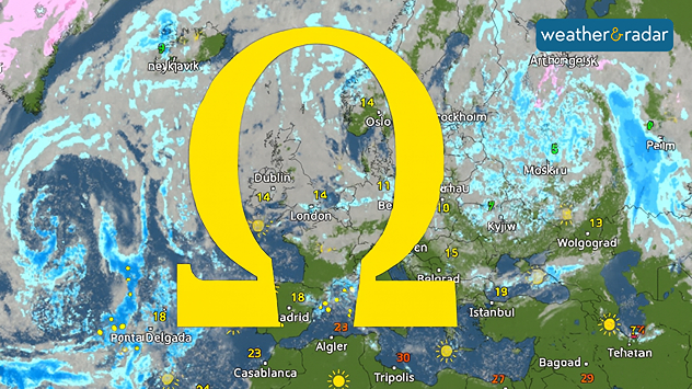
This weather situation is referred to as an omega or blocking weather situation.

For days now, there has been little change in the weather: with little sun to be seen here but plenty of fog and cloud. This is due to a so-called omega high.

In summer, it causes intense heat, but in autumn and winter, it causes persistent grey skies.

It owes its name to the imaginary line along the lows and highs in the shape of the Greek letter Ω on the weather map. In the middle, over the UK and Ireland, is a stable high-pressure area, flanked by two lows. The high blocks the exchange of air over Europe, deflects lows and causes a stable picture.

The result: the weather remains consistent for long periods of time, depending on the region, either sunny and mild or cloudy and foggy. Such conditions can last for days or even weeks, often making the autumn and winter months a real test of patience.

Birgit Heck
Ryan Hathaway
More on the topic
The Perseids reach their peak. Shooting stars overhead. . . Tuesday, 11 August 2026
Shooting stars in the night sky
Tuesday, 11 August 2026

Shooting stars overhead

The Perseids reach their peak
Huge hailstones in Poland. Severe weather hits towns. . . Friday, 7 August 2026
Friday, 7 August 2026

Severe weather hits towns

Huge hailstones in Poland
Solar eclipse on Wednesday. Save the date. . . Monday, 10 August 2026
People are watching a solar eclipse. The sun is already partially obscured. Next to it is the weather radar forecast for Wednesday, showing an almost cloudless sky.
Monday, 10 August 2026

Save the date

Solar eclipse on Wednesday
All weather news
This might also interest you
Turbulent weather in the Canary Islands. Storm and rain. . . Friday, 12 December 2025
Weather graphic showing rain and wind fields over the Canary Islands and a central warning symbol.
Friday, 12 December 2025

Storm and rain

Turbulent weather in the Canary Islands
Historic Storm Éowyn arrives. On this day.... . . Saturday, 24 January 2026
Split image showing a person in a yellow jacket struggling against strong winds and heavy rain on a street at night on the left, and an Irish wind forecast map on the right with red and purple shading, gusts up to 75 mph, and a wind warning icon, divided by a curved white line.
Saturday, 24 January 2026

On this day...

Historic Storm Éowyn arrives
Seasonal warmth between spring thunder. Your weather - Your shots. . . Sunday, 19 April 2026
Split image showing coastal sunset with layered lenticular clouds over rooftops and palm trees on the left, and a green valley with river and hills under soft daylight on the right.
Sunday, 19 April 2026

Your weather - Your shots

Seasonal warmth between spring thunder
All articles
Weather & Radar

Weather & Radar is also available on

Google Play StoreApp Store

Company

Contact us Privacy Policy Legal info Accessibility statement

Services

Uploader

Socials

facebooktwittertikToklinkList