Home
Weather London
WeatherRadar
RainfallRadar
TemperatureRadar
WindRadar
LightningRadar
Weather News
Editor's Pick
Discover the app
Weather widget
Contact us
Apps
Career
    Home / Editor's Pick /

    Crete and Spain: Severe weather in holiday spots

09:17
1 October 2026

Crete and Spain
Severe weather in holiday spots

Anyone currently on holiday in the Mediterranean should keep a close eye on the forecast. In Crete, some areas are set to receive over 300 mm of rain by the weekend, with even significantly higher amounts locally.

With rainfall of this magnitude, roads can become flooded within a short space of time. Flash floods and landslides are also possible – so caution is advised, particularly when out and about in gorges or mountainous areas.

Follow the latest developments liveClick here for the WeatherRadar

Wind is also a factor: in the Aegean Sea, gusts of over 50 miles per hour are possible, and in some areas even exceeding 75 mph. This may lead to restrictions along the coasts and on ferry services.

Turbulence returns to Spain too

From Thursday, Spain’s east coast will also be hit once again by severe thunderstorms and heavy rainfall. Flooding is also possible there.

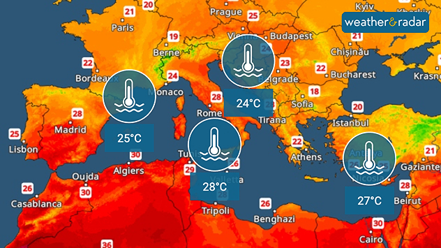
Current water temperatures in the Mediterranean.

The unusually warm Mediterranean Sea is playing into the hands of the storms. The water is still around 25°C across much of the region – in the western Mediterranean, this is 3 to 5 degrees warmer than usual for this time of year.

As a result, there is a particularly large amount of moisture available to fuel heavy rainfall.

Weather & Radar editorial team
More on the topic
Autumn brings the first snow. Scandinavia turns white. . . Wednesday, 7 October 2026
Split screen. On the left, a weather map of Norway showing snow and rain. On the right: Scandinavia covered in snow.
Wednesday, 7 October 2026

Scandinavia turns white

Autumn brings the first snow
Hurricane threatens the US coast. First storm of the season. . . Thursday, 8 October 2026
The WindRadar shows a powerful hurricane off the US Gulf Coast. Wind speeds of 75 miles per hour are being recorded around the centre of the storm.
Thursday, 8 October 2026

First storm of the season

Hurricane threatens the US coast
Severe weather in Spain and Greece. Streets under water. . . Monday, 5 October 2026
Severe weather near Barcelona, alongside a weather radar map showing heavy rain and thunderstorms.
Monday, 5 October 2026

Streets under water

Severe weather in Spain and Greece
All weather news
This might also interest you
Flooding, gales, and heavy snow. Storm Chandra. . . Tuesday, 27 January 2026
Split image showing aerial flooding in a town with muddy water covering roads on the left, and a rural road on the right blocked by heavy snowfall with vans stopped and a person walking in snow.
Tuesday, 27 January 2026

Storm Chandra

Flooding, gales, and heavy snow
A stormy week in the skies above. Your weather - Your shots. . . Sunday, 30 August 2026
Split image showing lightning branching beneath dark storm clouds above rooftops on the left and an orange-pink sunset over a calm sea on the right.
Sunday, 30 August 2026

Your weather - Your shots

A stormy week in the skies above
Super Typhoon Bavi threatens Taiwan. Up to 1,000 mm of rain. . . Wednesday, 8 July 2026
The image shows an intense tropical cyclone over the western Pacific, east of Taiwan and the Philippines. The centre of the system is depicted as a light purple and white vortex with a clearly visible eye, surrounded by a ring of red and orange areas indicating the strongest wind speeds. A white arrow marks the typhoon’s predicted track towards the north-west, in the direction of Taiwan. To the west of the storm lie the Philippines, with the cities of Manila and Cebu; to the north of these lies Taiwan, with Taipei. Further west, the Chinese coast, including Hong Kong, and parts of Vietnam can be seen. The coloured wind map shows predominantly green areas outside the storm’s core, indicating significantly weaker winds. White streamlines illustrate the typhoon’s anti-clockwise circulation in the Northern Hemisphere. The highest wind speeds are concentrated around the eye of the cyclone.
Wednesday, 8 July 2026

Up to 1,000 mm of rain

Super Typhoon Bavi threatens Taiwan
All articles
Weather & Radar

Weather & Radar is also available on

Google Play StoreApp Store

Company

Contact us Privacy Policy Legal info Accessibility statement

Services

Uploader

Socials

facebooktwittertikToklinkList