Home
Weather London
WeatherRadar
RainfallRadar
TemperatureRadar
WindRadar
LightningRadar
Weather News
Editor's Pick
Discover the app
Weather widget
Contact us
Apps
Career
    Home / Editor's Pick /

    Cosy versus wintry: Big contrast in Europe's spring weather

10:00
23 April 2026

Cosy versus wintry
Big contrast in Europe's spring weather

Parts of southern and western Europe already feel like early summer. while in Scandinavia snow is falling once again.

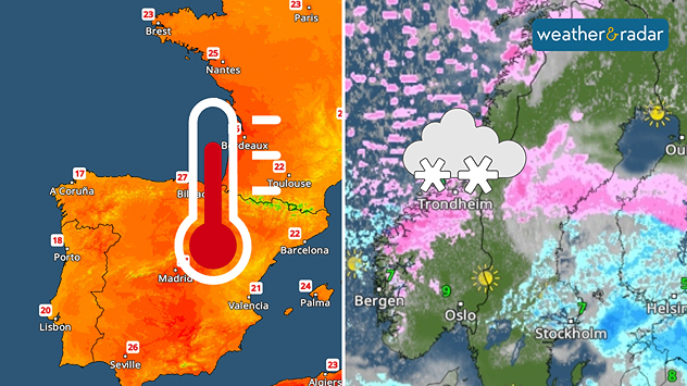
Europe is currently a tale of two extremes: bright and sunny from the Mediterranean to England with highs ranging from 18 to 25 °C, however Northern Europe remains significantly colder and wintry.

In Scandinavia, late winter is making a comeback. From Friday onwards, there will be prolonged snowfall in northern Norway as far as Lapland. By Sunday, snowflakes are possible as far as the Baltic states.

Snow versus spring weatherWeatherRadar Europe

There will be plenty of fresh snow, particularly in the Norwegian mountains. In areas affected by wind-driven snow, up to half a metre is expected over the weekend, whilst elsewhere the snowfall will be more in the region of 5 to 20 centimetres. Further south, it will often remain wet with rain or sleet.

A look at the broader weather picture explains the contrasting conditions: a low-pressure system over north-eastern Europe is pushing cold polar air towards Ukraine until the weekend.

As a result, temperatures will drop noticeably in Poland and the Baltic states. At the same time, warm air is flowing in from the south-west as far as Central Europe.

Weather & Radar editorial team
More on the topic
Drought for North Wales and Upper Severn. 2% of average rainfall. . . Thursday, 23 July 2026
Split image showing a July rainfall anomaly map of Europe on the left with below-average rainfall across the UK, Ireland, and much of western and central Europe, and an active moorland wildfire on the right producing flames and thick smoke near homes.
Thursday, 23 July 2026

2% of average rainfall

Drought for North Wales and Upper Severn
Heat becoming a bigger factor in drought. New study. . . Thursday, 23 July 2026
A hand holds dry, dusty earth above a parched field. The ground is cracked and covered with plant debris – a sign of prolonged drought.
Thursday, 23 July 2026

New study

Heat becoming a bigger factor in drought
Rain returns to end dry spell in places. Jet stream delivery. . . Thursday, 23 July 2026
Split weather graphic showing widespread showers across the UK and Ireland on the left, and a wind forecast map on the right with a windsock icon and gusts of 25 to 35 mph, highlighting breezy conditions across the two countries.
Thursday, 23 July 2026

Jet stream delivery

Rain returns to end dry spell in places
All weather news
This might also interest you
Turbulent weather in the Canary Islands. Storm and rain. . . Friday, 12 December 2025
Weather graphic showing rain and wind fields over the Canary Islands and a central warning symbol.
Friday, 12 December 2025

Storm and rain

Turbulent weather in the Canary Islands
New records for England and Wales. Broken again tomorrow?. . . Thursday, 25 June 2026
Temperature map of southwest Britain on 25.06 showing extreme heat across southern Wales and southwest England, with Bute Park in Cardiff highlighted at 34.2°C and Yeovilton at 36.4°C amid widespread deep red heat zones.
Thursday, 25 June 2026

Broken again tomorrow?

New records for England and Wales
Flooding, gales, and heavy snow. Storm Chandra. . . Tuesday, 27 January 2026
Split image showing aerial flooding in a town with muddy water covering roads on the left, and a rural road on the right blocked by heavy snowfall with vans stopped and a person walking in snow.
Tuesday, 27 January 2026

Storm Chandra

Flooding, gales, and heavy snow
All articles
Weather & Radar

Weather & Radar is also available on

Google Play StoreApp Store

Company

Contact us Privacy Policy Legal info Accessibility statement

Services

Uploader

Socials

facebooktwittertikToklinkList