Home
Weather London
WeatherRadar
RainfallRadar
TemperatureRadar
WindRadar
LightningRadar
Weather News
Editor's Pick
Discover the app
Weather widget
Contact us
Apps
Career
    Home / Editor's Pick /

    Contrasts in Europe - heatwave versus storm system

11:00
7 July 2026

Contrasts in Europe
Heatwave versus storm system

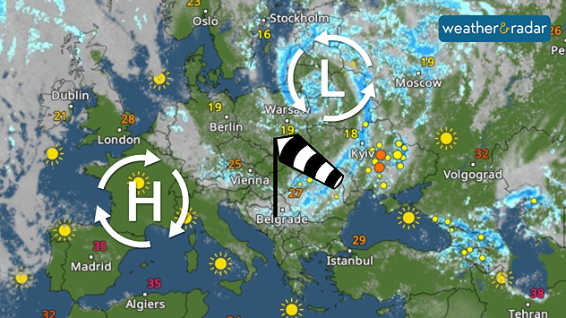
Europe is currently experiencing extreme weather contrasts, with a temperature difference of more than 20 degrees between the Iberian Peninsula and the Baltic states.

In Spain, Portugal, and parts of France, temperatures are soaring to 40 °C. This is due to a fresh heat dome: a powerful high-pressure system is trapping the warm air and causing it to heat up further day by day.

A storm system swirls over the Baltic States on Wednesday. In south-western Europe, it is sunny under high-pressure.

The situation is quite different in northern Europe. A small storm system will form over the Baltic Sea on Wednesday, bringing strong winds and significantly cooler air, particularly to Poland and the Baltic states. Temperatures along the North Sea and Baltic Sea coasts will often reach only 16 to 18 °C.

Try out the new video feature in the Weather & Radar app

If you’re out and about, why not share your weather moment with us? We look forward to seeing your video!

Tommy Kühnlein

More on the topic

Heavy rain again in the south of France. Another bout of disruption. . . Wednesday, 4 November 2026
Split image showing heavy rain and lightning near Montpellier, Marseille and Monaco on a weather map, alongside cars stranded on a flooded road.
Wednesday, 4 November 2026

Another bout of disruption

Heavy rain again in the south of France
Further fog disruption expected. Growing dense overnight. . . Monday, 9 November 2026
Weather map showing widespread fog across the English Midlands, with a red fog warning symbol near Nottingham and temperatures of 4–6°C.
Monday, 9 November 2026

Growing dense overnight

Further fog disruption expected
Autumn is the season for fog. High pressure, but no sun. . . Thursday, 5 November 2026
A split-screen image showing the weather radar for Europe and a mountain landscape. On the right, snow-capped peaks rise above a thick blanket of fog against a blue sky.
Thursday, 5 November 2026

High pressure, but no sun

Autumn is the season for fog
All weather news

This might also interest you

A stormy week in the skies above. Your weather - Your shots. . . Sunday, 30 August 2026
Split image showing lightning branching beneath dark storm clouds above rooftops on the left and an orange-pink sunset over a calm sea on the right.
Sunday, 30 August 2026

Your weather - Your shots

A stormy week in the skies above
Seasonal warmth between spring thunder. Your weather - Your shots. . . Sunday, 19 April 2026
Split image showing coastal sunset with layered lenticular clouds over rooftops and palm trees on the left, and a green valley with river and hills under soft daylight on the right.
Sunday, 19 April 2026

Your weather - Your shots

Seasonal warmth between spring thunder
A frozen start to the weekend. Icy conditions. . . Friday, 13 February 2026
UK temperature map dated 14.02 showing widespread subzero values in blue shading, with readings such as −4 in Glasgow, −3 in Dublin, and −2 in London, alongside a blue thermometer icon.
Friday, 13 February 2026

Icy conditions

A frozen start to the weekend
All articles
Weather & Radar

Weather & Radar is also available on

Google Play StoreApp Store

Company

Contact us Privacy Policy Legal info Accessibility statement

Services

Uploader

Socials

facebooktwittertikToklinkList