Home
Weather London
WeatherRadar
RainfallRadar
TemperatureRadar
WindRadar
LightningRadar
Weather News
Editor's Pick
Discover the app
Weather widget
Contact us
Apps
Career
    Home / Editor's Pick /

    Contrasts in Europe - heatwave versus storm system

11:00
7 July 2026

Contrasts in Europe
Heatwave versus storm system

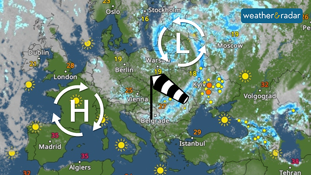
Europe is currently experiencing extreme weather contrasts, with a temperature difference of more than 20 degrees between the Iberian Peninsula and the Baltic states.

In Spain, Portugal, and parts of France, temperatures are soaring to 40 °C. This is due to a fresh heat dome: a powerful high-pressure system is trapping the warm air and causing it to heat up further day by day.

A storm system swirls over the Baltic States on Wednesday. In south-western Europe, it is sunny under high-pressure.

The situation is quite different in northern Europe. A small storm system will form over the Baltic Sea on Wednesday, bringing strong winds and significantly cooler air, particularly to Poland and the Baltic states. Temperatures along the North Sea and Baltic Sea coasts will often reach only 16 to 18 °C.

Try out the new video feature in the Weather & Radar app

If you’re out and about, why not share your weather moment with us? We look forward to seeing your video!

Tommy Kühnlein
More on the topic
Rain returns to end dry spell in places. Jet stream delivery. . . Thursday, 23 July 2026
Split weather graphic showing widespread showers across the UK and Ireland on the left, and a wind forecast map on the right with a windsock icon and gusts of 25 to 35 mph, highlighting breezy conditions across the two countries.
Thursday, 23 July 2026

Jet stream delivery

Rain returns to end dry spell in places
Heat becoming a bigger factor in drought. New study. . . Thursday, 23 July 2026
A hand holds dry, dusty earth above a parched field. The ground is cracked and covered with plant debris – a sign of prolonged drought.
Thursday, 23 July 2026

New study

Heat becoming a bigger factor in drought
Icy spells in the Southern Hemisphere. Snow in the Andes. . . Tuesday, 28 July 2026
A composite image showing a temperature radar map of South America and a snow-covered town in Chile. The winter cold is bringing heavy snowfall to the Andes and, in some areas, snow down to lower altitudes.
Tuesday, 28 July 2026

Snow in the Andes

Icy spells in the Southern Hemisphere
All weather news
This might also interest you
A frozen start to the weekend. Icy conditions. . . Friday, 13 February 2026
UK temperature map dated 14.02 showing widespread subzero values in blue shading, with readings such as −4 in Glasgow, −3 in Dublin, and −2 in London, alongside a blue thermometer icon.
Friday, 13 February 2026

Icy conditions

A frozen start to the weekend
Historic Storm Éowyn arrives. On this day.... . . Saturday, 24 January 2026
Split image showing a person in a yellow jacket struggling against strong winds and heavy rain on a street at night on the left, and an Irish wind forecast map on the right with red and purple shading, gusts up to 75 mph, and a wind warning icon, divided by a curved white line.
Saturday, 24 January 2026

On this day...

Historic Storm Éowyn arrives
Super Typhoon Bavi threatens Taiwan. Up to 1,000 mm of rain. . . Wednesday, 8 July 2026
The image shows an intense tropical cyclone over the western Pacific, east of Taiwan and the Philippines. The centre of the system is depicted as a light purple and white vortex with a clearly visible eye, surrounded by a ring of red and orange areas indicating the strongest wind speeds. A white arrow marks the typhoon’s predicted track towards the north-west, in the direction of Taiwan. To the west of the storm lie the Philippines, with the cities of Manila and Cebu; to the north of these lies Taiwan, with Taipei. Further west, the Chinese coast, including Hong Kong, and parts of Vietnam can be seen. The coloured wind map shows predominantly green areas outside the storm’s core, indicating significantly weaker winds. White streamlines illustrate the typhoon’s anti-clockwise circulation in the Northern Hemisphere. The highest wind speeds are concentrated around the eye of the cyclone.
Wednesday, 8 July 2026

Up to 1,000 mm of rain

Super Typhoon Bavi threatens Taiwan
All articles
Weather & Radar

Weather & Radar is also available on

Google Play StoreApp Store

Company

Contact us Privacy Policy Legal info Accessibility statement

Services

Uploader

Socials

facebooktwittertikToklinkList