Home
Weather London
WeatherRadar
RainfallRadar
TemperatureRadar
WindRadar
LightningRadar
Weather News
Editor's Pick
Discover the app
Weather widget
Contact us
Apps
Career
    Home / Editor's Pick /

    Commonwealth Games 2026 - A wet start before conditions settle

08:00
22 July 2026

Commonwealth Games 2026
A wet start before conditions settle

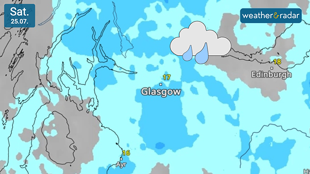
Weather forecast map of Scotland, centred on Glasgow, on Saturday 25.07 showing widespread rain across western and central Scotland, including the city, with temperatures around 16 to 18°C and a rain cloud icon highlighting wet conditions.
The first weekend of the games will be unpleasant at times with rain passing through.

The Commonwealth Games return to the UK for the 23rd edition being hosted in Glasgow over the next week with conditions looking mixed.

The games officially begin on Thursday with an opening ceremony at the Hydro, before events get started on Friday, running until August 2nd.

While many events take place indoors, the athletic and para athletic events will be hosted at Scotstoun Stadium, and many thousands of spectators will also have an eye on the forecast as they make their way between venues and enjoy all that Glasgow has to offer.

After the long dry spell, the skies over Glasgow for the games will often be dull to begin with, with heavier rainfall expected on Saturday followed by showers at times into the new week and strong winds to begin with.

Following the early rain, the general trend shows a drier outlook for the remainder of the games with increasing amounts of sunshine over the week. Outdoor events are not scheduled to begin until Monday, where they could face some delays due to the rain.

Repeat in weather

This year's conditions are very similar to those in Birmingham for the 2022 games which also occurred after record heat transitioned to cooler, wetter weather.

Temperatures do remain around the low-20s next week. Whether you're attending the games yourself, or are an avid fan watching from home, keep an eye on the WeatherRadar at all times to see how the days are looking.

Glasgow

We
16
18
Th
11
17
Fr
9
16
Sa
11
18
Su
10
20
Mo
13
19
Tu
11
19
We
11
19
Th
9
19
Fr
10
20
Sa
11
21
Su
12
20
Mo
12
20
Tu
11
20
Max (°C)
Min (°C)
moreless

Ryan Hathaway
More on the topic
Typhoon warning for China. Up to 500 mm of rain. . . Friday, 24 July 2026
Weather map of the southern Chinese coast and Taiwan showing a powerful tropical cyclone. The eye of the storm is located near the coastal city of Shantou in the Chinese province of Guangdong. Around the centre, intense shades of red, pink and violet indicate gale-force winds, whilst a large orange wind field extends as far as the west coast of Taiwan. An overlaid windsack warning sign indicates dangerous storm winds. Cities such as Hong Kong, Guangzhou, Xiamen, Taipei and Taichung are shown, as are wind speeds and white flow lines illustrating the cyclonic air circulation.
Friday, 24 July 2026

Up to 500 mm of rain

Typhoon warning for China
Catastrophic forest fires in Europe. Thousands evacuated. . . Monday, 27 July 2026
A composite image showing a temperature map of south-western Europe and a drone shot of a forest fire near Cap Ferret. A warning symbol featuring a flame indicates the increased risk of forest fires.
Monday, 27 July 2026

Thousands evacuated

Catastrophic forest fires in Europe
Rain returns to end dry spell in places. Jet stream delivery. . . Thursday, 23 July 2026
Split weather graphic showing widespread showers across the UK and Ireland on the left, and a wind forecast map on the right with a windsock icon and gusts of 25 to 35 mph, highlighting breezy conditions across the two countries.
Thursday, 23 July 2026

Jet stream delivery

Rain returns to end dry spell in places
All weather news
This might also interest you
Super Typhoon Bavi threatens Taiwan. Up to 1,000 mm of rain. . . Wednesday, 8 July 2026
The image shows an intense tropical cyclone over the western Pacific, east of Taiwan and the Philippines. The centre of the system is depicted as a light purple and white vortex with a clearly visible eye, surrounded by a ring of red and orange areas indicating the strongest wind speeds. A white arrow marks the typhoon’s predicted track towards the north-west, in the direction of Taiwan. To the west of the storm lie the Philippines, with the cities of Manila and Cebu; to the north of these lies Taiwan, with Taipei. Further west, the Chinese coast, including Hong Kong, and parts of Vietnam can be seen. The coloured wind map shows predominantly green areas outside the storm’s core, indicating significantly weaker winds. White streamlines illustrate the typhoon’s anti-clockwise circulation in the Northern Hemisphere. The highest wind speeds are concentrated around the eye of the cyclone.
Wednesday, 8 July 2026

Up to 1,000 mm of rain

Super Typhoon Bavi threatens Taiwan
Bright and warm conditions take hold. Spring-like outlook. . . Thursday, 23 April 2026
Split UK map showing warm temperatures up to 21 degrees in orange on the left and clear sunny conditions with temperatures from 12 to 18 degrees on the right, with sun icons across the country.
Thursday, 23 April 2026

Spring-like outlook

Bright and warm conditions take hold
Storm Chandra makes impact. Severe gales & heavy rain. . . Tuesday, 27 January 2026
Split image showing strong winds over the UK on a forecast map and widespread rain and snow on a weather radar map.
Tuesday, 27 January 2026

Severe gales & heavy rain

Storm Chandra makes impact
All articles
Weather & Radar

Weather & Radar is also available on

Google Play StoreApp Store

Company

Contact us Privacy Policy Legal info Accessibility statement

Services

Uploader

Socials

facebooktwittertikToklinkList