Home
Weather London
WeatherRadar
RainfallRadar
TemperatureRadar
WindRadar
LightningRadar
Weather News
Editor's Pick
Discover the app
Weather widget
Contact us
Apps
Career
    Home / Editor's Pick /

    Cloudy week - Understanding clouds on the WeatherRadar

07:00
25 September 2025

Cloudy week
Understanding clouds on the WeatherRadar

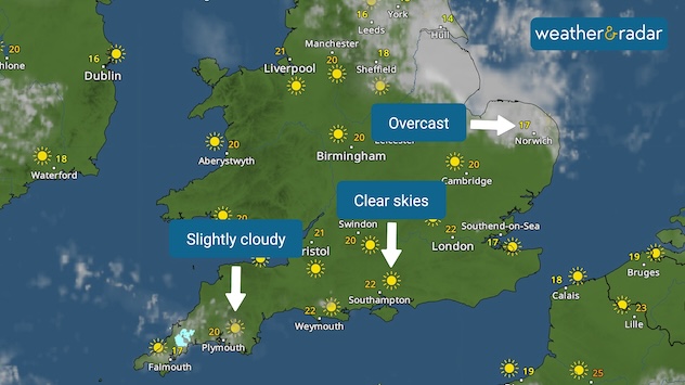
Examples of different cloud types on the WeatherRadar.

There is plenty of cloud cover this week, do you know how to gauge clouds on the WeatherRadar?

Clouds on the WeatherRadar have various thicknesses and different levels of transparency, as in real life, so that you can get a realistic picture of how the weather looks on the ground.

Some clouds, for example thick low clouds or extensive rain-bearing clouds, will absorb all the sunlight, such as stratocumulus and nimbostratus. Others, such as thinner, wispier high clouds, such as cirrus, are often semi-transparent allowing plenty of sunshine and are associated with drier weather.

You will also be able to see sun and moon symbols under thinner clouds, representing how much sunshine or moonlight will be getting through the clouds.

Check the latest cloud cover forecast on the WeatherRadar for your area!

Ryan Hathaway
More on the topic
New heatwave in southern Europe. Up to 45 degrees in Spain. . . Tuesday, 21 July 2026
Split temperature map showing extreme heat across Spain on the left and Greece on the right, with temperatures reaching 44°C near Murcia, around 40°C in parts of Greece, and a large thermometer icon highlighting dangerous heat.
Tuesday, 21 July 2026

Up to 45 degrees in Spain

New heatwave in southern Europe
Heatwave breaks after remarkable run. Two weeks of heat. . . Monday, 20 July 2026
Split image showing the London skyline in hazy golden sunshine on the left and a July temperature anomaly map of Europe on the right, with above-average temperatures across the UK, Ireland, and much of western Europe highlighted in red alongside a thermometer icon.
Monday, 20 July 2026

Two weeks of heat

Heatwave breaks after remarkable run
Rain returns to end dry spell in places. Jet stream delivery. . . Thursday, 23 July 2026
Split weather graphic showing widespread showers across the UK and Ireland on the left, and a wind forecast map on the right with a windsock icon and gusts of 25 to 35 mph, highlighting breezy conditions across the two countries.
Thursday, 23 July 2026

Jet stream delivery

Rain returns to end dry spell in places
All weather news
This might also interest you
Flooding, gales, and heavy snow. Storm Chandra. . . Tuesday, 27 January 2026
Split image showing aerial flooding in a town with muddy water covering roads on the left, and a rural road on the right blocked by heavy snowfall with vans stopped and a person walking in snow.
Tuesday, 27 January 2026

Storm Chandra

Flooding, gales, and heavy snow
Seasonal warmth between spring thunder. Your weather - Your shots. . . Sunday, 19 April 2026
Split image showing coastal sunset with layered lenticular clouds over rooftops and palm trees on the left, and a green valley with river and hills under soft daylight on the right.
Sunday, 19 April 2026

Your weather - Your shots

Seasonal warmth between spring thunder
New records for England and Wales. Broken again tomorrow?. . . Thursday, 25 June 2026
Temperature map of southwest Britain on 25.06 showing extreme heat across southern Wales and southwest England, with Bute Park in Cardiff highlighted at 34.2°C and Yeovilton at 36.4°C amid widespread deep red heat zones.
Thursday, 25 June 2026

Broken again tomorrow?

New records for England and Wales
All articles
Weather & Radar

Weather & Radar is also available on

Google Play StoreApp Store

Company

Contact us Privacy Policy Legal info Accessibility statement

Services

Uploader

Socials

facebooktwittertikToklinkList