Home
Weather London
WeatherRadar
RainfallRadar
TemperatureRadar
WindRadar
LightningRadar
Weather News
Editor's Pick
Discover the app
Weather widget
Contact us
Apps
Career
    Home / Editor's Pick /

    Climate report - 2025: Third-warmest year on record

13:48
16 January 2026

Climate report
2025: Third-warmest year on record

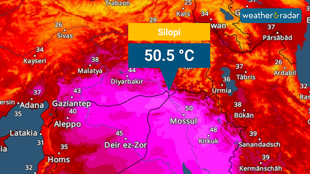
Temperature record in Silopi, Turkey in July 2025, near the Iraqi border saw a high of 50.5 °C.

The year 2025 was the third warmest since records began. 2024 remains the warmest, 2023 the second-warmest year.

The global temperatures for the years 2023 to 2025 were more than 1.5 degrees higher than in the pre-industrial era, based on a three-year average. This is the first time that a three-year period has exceeded this threshold.

What does the climate crisis mean in everyday life?

People do not primarily feel climate change through gradual changes, but through extreme weather events. In 2025, half of the world's land area experienced more days with severe heat stress than average.  

In addition, wind in hot and dry areas often contributed to the spread of forest fires. According to the Copernicus report, emissions from forest fires in Europe peaked in 2025.

Verena Leyendecker
More on the topic
Rain returns to end dry spell in places. Jet stream delivery. . . Thursday, 23 July 2026
Split weather graphic showing widespread showers across the UK and Ireland on the left, and a wind forecast map on the right with a windsock icon and gusts of 25 to 35 mph, highlighting breezy conditions across the two countries.
Thursday, 23 July 2026

Jet stream delivery

Rain returns to end dry spell in places
Clouds return to capture the scene. Your weather - Your shots. . . Sunday, 26 July 2026
Waxing crescent Moon above vivid pink and magenta sunset clouds, with silhouetted trees along the horizon beneath a deepening blue twilight sky.
Sunday, 26 July 2026

Your weather - Your shots

Clouds return to capture the scene
Drought for North Wales and Upper Severn. 2% of average rainfall. . . Thursday, 23 July 2026
Split image showing a July rainfall anomaly map of Europe on the left with below-average rainfall across the UK, Ireland, and much of western and central Europe, and an active moorland wildfire on the right producing flames and thick smoke near homes.
Thursday, 23 July 2026

2% of average rainfall

Drought for North Wales and Upper Severn
All weather news
This might also interest you
Flooding, gales, and heavy snow. Storm Chandra. . . Tuesday, 27 January 2026
Split image showing aerial flooding in a town with muddy water covering roads on the left, and a rural road on the right blocked by heavy snowfall with vans stopped and a person walking in snow.
Tuesday, 27 January 2026

Storm Chandra

Flooding, gales, and heavy snow
Historic Storm Éowyn arrives. On this day.... . . Saturday, 24 January 2026
Split image showing a person in a yellow jacket struggling against strong winds and heavy rain on a street at night on the left, and an Irish wind forecast map on the right with red and purple shading, gusts up to 75 mph, and a wind warning icon, divided by a curved white line.
Saturday, 24 January 2026

On this day...

Historic Storm Éowyn arrives
Super Typhoon Bavi threatens Taiwan. Up to 1,000 mm of rain. . . Wednesday, 8 July 2026
The image shows an intense tropical cyclone over the western Pacific, east of Taiwan and the Philippines. The centre of the system is depicted as a light purple and white vortex with a clearly visible eye, surrounded by a ring of red and orange areas indicating the strongest wind speeds. A white arrow marks the typhoon’s predicted track towards the north-west, in the direction of Taiwan. To the west of the storm lie the Philippines, with the cities of Manila and Cebu; to the north of these lies Taiwan, with Taipei. Further west, the Chinese coast, including Hong Kong, and parts of Vietnam can be seen. The coloured wind map shows predominantly green areas outside the storm’s core, indicating significantly weaker winds. White streamlines illustrate the typhoon’s anti-clockwise circulation in the Northern Hemisphere. The highest wind speeds are concentrated around the eye of the cyclone.
Wednesday, 8 July 2026

Up to 1,000 mm of rain

Super Typhoon Bavi threatens Taiwan
All articles
Weather & Radar

Weather & Radar is also available on

Google Play StoreApp Store

Company

Contact us Privacy Policy Legal info Accessibility statement

Services

Uploader

Socials

facebooktwittertikToklinkList