Home
Weather London
WeatherRadar
RainfallRadar
TemperatureRadar
WindRadar
LightningRadar
Weather News
Editor's Pick
Discover the app
Weather widget
Contact us
Apps
Career
    Home / Editor's Pick /

    Catastrophic forest fires in Europe - hundreds of thousands forced to flee

09:27
27 July 2026

Thousands evacuated
Catastrophic forest fires in Europe

The wildfire situation in south-west France is continuing to worsen. Around Bordeaux, thousands of emergency services personnel are battling the flames, which are spreading rapidly due to the dry conditions and wind.

In France alone, around 250,000 people have now been forced to leave their homes, campsites or holiday accommodation. Nationwide, more than 110,000 hectares have already been burnt – more than ever before by the end of July in any given year.

Did you know?

Common causes of forest fires include discarded cigarettes, open fires, barbecues, sparks from machinery or vehicles, and arson.

Huge areas of forest have been destroyed, particularly in the Gironde department. In some places, the fires are now only about 15 kilometres from Bordeaux. Although there are no plans to evacuate the city, concerns are growing that the fires may spread further.

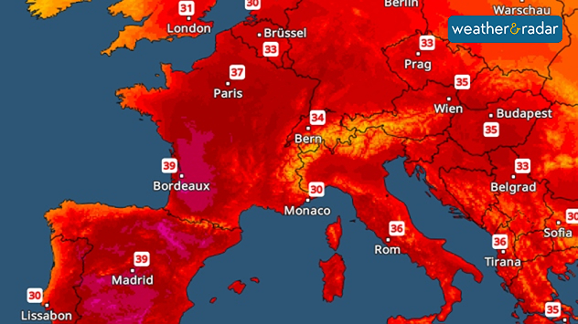
Temperature Radar showing Wednesday’s highest temperatures across Europe. Spain and south-west France in particular are highlighted in bold, with temperatures reaching 39 degrees.
TemperatureRadar: The next heatwave is set to hit on Wednesday, with maximum temperatures of up to 40 degrees.

In Spain, further evacuations are taking place, particularly around Madrid and near Valencia, due to a number of wildfires. Thousands of people are affected. The fires are also taking a heavy toll on wildlife, as many animals are unable to escape the flames quickly enough.

There is no sign of the situation easing. The next heatwave is set to arrive as early as Tuesday, with temperatures reaching around 40 degrees in some regions. This is likely to cause the drought and the risk of forest fires to increase further.

Rain remains in short supplyWeatherRadar Europe
Tommy Kühnlein
More on the topic
More comfortable night's sleep. Overnight low drops. . . Wednesday, 5 August 2026
Morning temperature map of the UK and Ireland showing cool conditions, with temperatures ranging from 7°C in South Wales to 13°C in southeast England. Ireland records 9–12°C, while much of England and Wales is between 8°C and 10°C. A blue thermometer icon highlights the cooler weather.
Wednesday, 5 August 2026

Overnight low drops

More comfortable night's sleep
The solar eclipse arrives tonight. Great visibility for most. . . Wednesday, 12 August 2026
Split image showing an annular solar eclipse on the left and a UK and Ireland weather map on the right with mostly sunny skies, temperatures of 30–31°C in England and 27°C in Dublin.
Wednesday, 12 August 2026

Great visibility for most

The solar eclipse arrives tonight
Getting through the latest heatwave. Tips to beat the heat. . . Tuesday, 11 August 2026
Split graphic showing temperatures up to 35°C in England and 28°C in Ireland beside a person applying sunscreen, with a heat warning symbol highlighting hot weather.
Tuesday, 11 August 2026

Tips to beat the heat

Getting through the latest heatwave
All weather news
This might also interest you
A frozen start to the weekend. Icy conditions. . . Friday, 13 February 2026
UK temperature map dated 14.02 showing widespread subzero values in blue shading, with readings such as −4 in Glasgow, −3 in Dublin, and −2 in London, alongside a blue thermometer icon.
Friday, 13 February 2026

Icy conditions

A frozen start to the weekend
New records for England and Wales. Broken again tomorrow?. . . Thursday, 25 June 2026
Temperature map of southwest Britain on 25.06 showing extreme heat across southern Wales and southwest England, with Bute Park in Cardiff highlighted at 34.2°C and Yeovilton at 36.4°C amid widespread deep red heat zones.
Thursday, 25 June 2026

Broken again tomorrow?

New records for England and Wales
Super Typhoon Bavi threatens Taiwan. Up to 1,000 mm of rain. . . Wednesday, 8 July 2026
The image shows an intense tropical cyclone over the western Pacific, east of Taiwan and the Philippines. The centre of the system is depicted as a light purple and white vortex with a clearly visible eye, surrounded by a ring of red and orange areas indicating the strongest wind speeds. A white arrow marks the typhoon’s predicted track towards the north-west, in the direction of Taiwan. To the west of the storm lie the Philippines, with the cities of Manila and Cebu; to the north of these lies Taiwan, with Taipei. Further west, the Chinese coast, including Hong Kong, and parts of Vietnam can be seen. The coloured wind map shows predominantly green areas outside the storm’s core, indicating significantly weaker winds. White streamlines illustrate the typhoon’s anti-clockwise circulation in the Northern Hemisphere. The highest wind speeds are concentrated around the eye of the cyclone.
Wednesday, 8 July 2026

Up to 1,000 mm of rain

Super Typhoon Bavi threatens Taiwan
All articles
Weather & Radar

Weather & Radar is also available on

Google Play StoreApp Store

Company

Contact us Privacy Policy Legal info Accessibility statement

Services

Uploader

Socials

facebooktwittertikToklinkList