Home
Weather London
WeatherRadar
RainfallRadar
TemperatureRadar
WindRadar
LightningRadar
Weather News
Editor's Pick
Discover the app
Weather widget
Contact us
Apps
Career
    Home / Weather News /

    Breakfast brief - Split with cooler north, hot south

04:00
15 August 2025

Breakfast brief
Split with cooler north, hot south

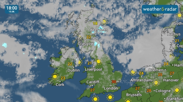
Weather map of the UK and Ireland showing clearer skies over England, Wales, and Ireland. A high of 30 °C in London. Cloudier in Scotland with a high of 22 °C in Glasgow.
Cooler in the north under cloud, still hot with the south's clearer skies.

A split in conditions emerges today with more overcast skies to the north cooling things down while it remains hot and sunny to the south.

Kickstarting your morning

Welcome to the breakfast brief, offering your first forecast of the day and a peep at weather around the world as captured by our users.

Weather outlook

Highs of around 30 °C mark the warmest areas in the south-east of England. Winds do get gusty in Shetland and the far north of Scotland but otherwise still calm.

Weather outlook

Every morning, we take a trip across the world courtesy of our international users around the globe!

We share shots from the UK and Ireland every Sunday right here, and throughout the week on our social channels.

If you want to get involved, just tap the image icon in the app, or use one of our dedicated uploaders for the UK or Ireland.

Weather & Radar editorial team
More on the topic
Heat-health alerts ahead of heatwave. Across England. . . Tuesday, 7 July 2026
Temperature map of the UK and western Europe showing hot conditions across Britain, with temperatures reaching 33°C near London, 29°C around Cardiff, 24°C near Liverpool, and a large heat warning symbol highlighting elevated heat risk.
Tuesday, 7 July 2026

Across England

Heat-health alerts ahead of heatwave
Cooler nights and lower dew points. Less oppressive heatwave. . . Thursday, 9 July 2026
Split image showing the London skyline in hazy golden sunset light in the left and an overnight temperature map of the UK and Ireland on the right, with minimum temperatures ranging from 13°C in northeast Scotland to 18°C in southern England.
Thursday, 9 July 2026

Less oppressive heatwave

Cooler nights and lower dew points
Heatwave versus storm system. Contrasts in Europe. . . Tuesday, 7 July 2026
A temperature map of Europe showing a major heatwave in the south-west and significantly cooler air in the north. Two thermometer symbols illustrate the stark contrast in temperature.
Tuesday, 7 July 2026

Contrasts in Europe

Heatwave versus storm system
All weather news
This might also interest you
Flooding, gales, and heavy snow. Storm Chandra. . . Tuesday, 27 January 2026
Split image showing aerial flooding in a town with muddy water covering roads on the left, and a rural road on the right blocked by heavy snowfall with vans stopped and a person walking in snow.
Tuesday, 27 January 2026

Storm Chandra

Flooding, gales, and heavy snow
Seasonal warmth between spring thunder. Your weather - Your shots. . . Sunday, 19 April 2026
Split image showing coastal sunset with layered lenticular clouds over rooftops and palm trees on the left, and a green valley with river and hills under soft daylight on the right.
Sunday, 19 April 2026

Your weather - Your shots

Seasonal warmth between spring thunder
Super Typhoon Bavi threatens Taiwan. Up to 1,000 mm of rain. . . Wednesday, 8 July 2026
The image shows an intense tropical cyclone over the western Pacific, east of Taiwan and the Philippines. The centre of the system is depicted as a light purple and white vortex with a clearly visible eye, surrounded by a ring of red and orange areas indicating the strongest wind speeds. A white arrow marks the typhoon’s predicted track towards the north-west, in the direction of Taiwan. To the west of the storm lie the Philippines, with the cities of Manila and Cebu; to the north of these lies Taiwan, with Taipei. Further west, the Chinese coast, including Hong Kong, and parts of Vietnam can be seen. The coloured wind map shows predominantly green areas outside the storm’s core, indicating significantly weaker winds. White streamlines illustrate the typhoon’s anti-clockwise circulation in the Northern Hemisphere. The highest wind speeds are concentrated around the eye of the cyclone.
Wednesday, 8 July 2026

Up to 1,000 mm of rain

Super Typhoon Bavi threatens Taiwan
All articles
Weather & Radar

Weather & Radar is also available on

Google Play StoreApp Store

Company

Contact us Privacy Policy Legal info Accessibility statement

Services

Uploader

Socials

facebooktwittertikToklinkList