Home
Weather London
WeatherRadar
RainfallRadar
TemperatureRadar
WindRadar
LightningRadar
Weather News
Editor's Pick
Discover the app
Weather widget
Contact us
Apps
Career
    Home / Editor's Pick /

    Blocking high brings anticyclonic gloom

15:00
3 November 2026

Overcast days
Blocking high brings anticyclonic gloom

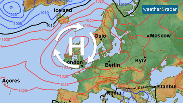
Synoptic weather map showing high pressure over the UK and western Europe, with a large H symbol and red isobars indicating 1030–1035 hPa.
A blocking high hangs over the UK and Ireland for much of this week.

High pressure is in control, and this often brings bright, clear skies, but not at the moment. The system overhead is known as a blocking high.

A blocking high is a persistent area of high pressure that can lead to stagnant weather conditions, often referred to as "anticyclonic gloom."

This phenomenon typically occurs when the high pressure becomes stationary, preventing the usual movement of weather systems.

As a blocking high establishes itself over the UK and Ireland, it can sometimes creates clear skies and dry weather in the short term, or, as it is now, trap cloud inside.

It can also exacerbate air quality issues, as pollution becomes trapped under the stable atmosphere. You can keep an eye on that with our app's Air Quality Index feature, though for now conditions are good and the pressure system is steadily moving towards Europe over the coming days.

Cloudy few days on the radarWeatherRadar
Ryan Hathaway

More on the topic

Europe set for a change in the weather. Turning more unsettled. . . Monday, 9 November 2026
European weather map showing low pressure over Scandinavia, pink snow bands across Norway and Sweden, blue rain areas and arrows indicating airflow.
Monday, 9 November 2026

Turning more unsettled

Europe set for a change in the weather
Front brings showers from the south-west. Brolly needed for some. . . Tuesday, 10 November 2026
Weather map showing blue rain bands across southern Ireland, Wales and southwest England, with a northeastward arrow and temperatures of 7–10°C.
Tuesday, 10 November 2026

Brolly needed for some

Front brings showers from the south-west
Europe caught between winter and summer. Frost and warmth. . . Friday, 6 November 2026
Temperature Radar showing freezing temperatures in northern and eastern Europe and temperatures above 20 degrees in Spain.
Friday, 6 November 2026

Frost and warmth

Europe caught between winter and summer
All weather news

This might also interest you

Storm Chandra makes impact. Severe gales & heavy rain. . . Tuesday, 27 January 2026
Split image showing strong winds over the UK on a forecast map and widespread rain and snow on a weather radar map.
Tuesday, 27 January 2026

Severe gales & heavy rain

Storm Chandra makes impact
A stormy week in the skies above. Your weather - Your shots. . . Sunday, 30 August 2026
Split image showing lightning branching beneath dark storm clouds above rooftops on the left and an orange-pink sunset over a calm sea on the right.
Sunday, 30 August 2026

Your weather - Your shots

A stormy week in the skies above
Long-term trends need a pinch of salt. 40 °C in July?. . . Tuesday, 30 June 2026
Temperature radar of 2022 heatwave where the all-time temperature record in the UK was set. Warning symbol overlain.
Tuesday, 30 June 2026

40 °C in July?

Long-term trends need a pinch of salt
All articles
Weather & Radar

Weather & Radar is also available on

Google Play StoreApp Store

Company

Contact us Privacy Policy Legal info Accessibility statement

Services

Uploader

Socials

facebooktwittertikToklinkList