Home
Weather London
WeatherRadar
RainfallRadar
TemperatureRadar
WindRadar
LightningRadar
Weather News
Editor's Pick
Discover the app
Weather widget
Contact us
Apps
Career
    Home / Editor's Pick /

    Before the cool-down: High UV Index in coming days

11:00
22 August 2023

Before the cool-down
High UV Index in coming days

sun flare

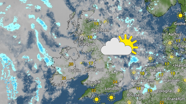
With only a few days left of the warm and sunny weather, don't get caught out as the UV reaches high levels across the UK and Ireland.

During summer the UV index in the UK often reaches moderate levels daily beneath unbroken sunshine. Even on a cloudy day, UV levels can still be high with UV able to be reflected and scattered in the clouds.

There are three types of UV rays: UVA, UVB, and UVC. UVC is the most dangerous form of UV radiation, but luckily this is absorbed by the atmosphere before it reaches Earth.

UVB penetrates the top layer of the skin and leads to sunburn. UVA is the most potent source which we are exposed to all year long. It can pass through windows and clouds and penetrates deep into our skin, leading to ageing and increasing our risk of skin cancer.

Because of the dangers associated with increased levels of UV, particularly in the spring and summer months when UV radiation is at its strongest, the UV Index was created. The higher the UV Index, the stronger the UV radiation and faster the skin will burn.

This week, UV levels could reach 'High' for your area as temperatures rise into the mid-to-high twenties beneath plenty of sunshine, reaching 7 on the hottest days.

At this level, there is a risk of burning within 30-60 minutes. As we spend more time outside, be sure to check the UV Index level near you inside our app!

It then looks to cool down by the weekend, but even beneath the strength of the sun your skin can still burn. Check the WeatherRadar for the latest.

Weather & Radar editorial team
More on the topic
Hottest summer on record for Ireland. Beating 2025's record. . . Thursday, 3 September 2026
Temperature map of Ireland showing 29°C in Dublin, 26°C in Cork, 24°C in Belfast, and 23°C in Galway, with a red thermometer icon.
Thursday, 3 September 2026

Beating 2025's record

Hottest summer on record for Ireland
A marked change in the weather. Cold front heading south. . . Monday, 7 September 2026
Map of Europe showing a cold front stretching from Scandinavia to Spain. Thunderstorms are shown in southern and central Europe.
Monday, 7 September 2026

Cold front heading south

A marked change in the weather
Autumn arrives with vivid colour. Your weather - Your shots. . . Sunday, 6 September 2026
Split image showing peach-lit textured clouds above silhouetted trees and golden cumulus clouds reflected in a calm canal lined with boats.
Sunday, 6 September 2026

Your weather - Your shots

Autumn arrives with vivid colour
All weather news
This might also interest you
Seasonal warmth between spring thunder. Your weather - Your shots. . . Sunday, 19 April 2026
Split image showing coastal sunset with layered lenticular clouds over rooftops and palm trees on the left, and a green valley with river and hills under soft daylight on the right.
Sunday, 19 April 2026

Your weather - Your shots

Seasonal warmth between spring thunder
Historic Storm Éowyn arrives. On this day.... . . Saturday, 24 January 2026
Split image showing a person in a yellow jacket struggling against strong winds and heavy rain on a street at night on the left, and an Irish wind forecast map on the right with red and purple shading, gusts up to 75 mph, and a wind warning icon, divided by a curved white line.
Saturday, 24 January 2026

On this day...

Historic Storm Éowyn arrives
Super Typhoon Bavi threatens Taiwan. Up to 1,000 mm of rain. . . Wednesday, 8 July 2026
The image shows an intense tropical cyclone over the western Pacific, east of Taiwan and the Philippines. The centre of the system is depicted as a light purple and white vortex with a clearly visible eye, surrounded by a ring of red and orange areas indicating the strongest wind speeds. A white arrow marks the typhoon’s predicted track towards the north-west, in the direction of Taiwan. To the west of the storm lie the Philippines, with the cities of Manila and Cebu; to the north of these lies Taiwan, with Taipei. Further west, the Chinese coast, including Hong Kong, and parts of Vietnam can be seen. The coloured wind map shows predominantly green areas outside the storm’s core, indicating significantly weaker winds. White streamlines illustrate the typhoon’s anti-clockwise circulation in the Northern Hemisphere. The highest wind speeds are concentrated around the eye of the cyclone.
Wednesday, 8 July 2026

Up to 1,000 mm of rain

Super Typhoon Bavi threatens Taiwan
All articles
Weather & Radar

Weather & Radar is also available on

Google Play StoreApp Store

Company

Contact us Privacy Policy Legal info Accessibility statement

Services

Uploader

Socials

facebooktwittertikToklinkList