Home
Weather London
WeatherRadar
RainfallRadar
TemperatureRadar
WindRadar
LightningRadar
Weather News
Editor's Pick
Discover the app
Weather widget
Contact us
Apps
Career
    Home / Editor's Pick /

    Back to freezing - Wintry feel to Thursday morning

09:00
25 March 2026

Back to freezing
Wintry feel to Thursday morning

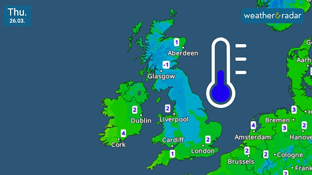
UK and Ireland temperature map dated Thu 26.03 showing widespread low values around −1 to 2 °C, with colder air across Scotland and a blue thermometer icon indicating chilly conditions.
Frosty start for many in the UK on Thursday.

Wrap up warm Thursday morning, the day starts frosty as temperatures drop to and around freezing overnight.

From central England and Wales, and north into Scotland, there will be a chilly bite for the start of the day.

Lows reach around -2 °C in north-west England, including Carlisle, and drop further in more rural areas of Scotland. This follows the return of snow for some on Wednesday.

Though mostly confined to higher ground, there is plenty of pink on the WeatherRadar. For most, this will reach the ground as rain, but particularly over hills wintry showers are expected.

This leads to Thursday morning, a cold start with sunshine which is soon masked by growing cloud cover.

Temperatures across Ireland and southern to eastern England also drop, but remain in the positive as Wednesday's gusting winds also fall away.

Ryan Hathaway

More on the topic

Autumn is the season for fog. High pressure, but no sun. . . Thursday, 5 November 2026
A split-screen image showing the weather radar for Europe and a mountain landscape. On the right, snow-capped peaks rise above a thick blanket of fog against a blue sky.
Thursday, 5 November 2026

High pressure, but no sun

Autumn is the season for fog
Summer heat in the middle of November. Unusual temperatures. . . Tuesday, 10 November 2026
The weather map shows the temperatures in south-eastern Europe and the Mediterranean region. It is particularly warm in the Balkans: temperatures in Belgrade are reaching 25 degrees. A red arrow indicates that warm air is flowing from the central Mediterranean towards Serbia. In Italy, Greece and Romania, too, temperatures are above 20 degrees in many places. By contrast, it is significantly cooler in the Alps and in parts of Central Europe.
Tuesday, 10 November 2026

Unusual temperatures

Summer heat in the middle of November
Heavy rain again in the south of France. Another bout of disruption. . . Wednesday, 4 November 2026
Split image showing heavy rain and lightning near Montpellier, Marseille and Monaco on a weather map, alongside cars stranded on a flooded road.
Wednesday, 4 November 2026

Another bout of disruption

Heavy rain again in the south of France
All weather news

This might also interest you

Flooding, gales, and heavy snow. Storm Chandra. . . Tuesday, 27 January 2026
Split image showing aerial flooding in a town with muddy water covering roads on the left, and a rural road on the right blocked by heavy snowfall with vans stopped and a person walking in snow.
Tuesday, 27 January 2026

Storm Chandra

Flooding, gales, and heavy snow
Long-term trends need a pinch of salt. 40 °C in July?. . . Tuesday, 30 June 2026
Temperature radar of 2022 heatwave where the all-time temperature record in the UK was set. Warning symbol overlain.
Tuesday, 30 June 2026

40 °C in July?

Long-term trends need a pinch of salt
Super Typhoon Bavi threatens Taiwan. Up to 1,000 mm of rain. . . Wednesday, 8 July 2026
The image shows an intense tropical cyclone over the western Pacific, east of Taiwan and the Philippines. The centre of the system is depicted as a light purple and white vortex with a clearly visible eye, surrounded by a ring of red and orange areas indicating the strongest wind speeds. A white arrow marks the typhoon’s predicted track towards the north-west, in the direction of Taiwan. To the west of the storm lie the Philippines, with the cities of Manila and Cebu; to the north of these lies Taiwan, with Taipei. Further west, the Chinese coast, including Hong Kong, and parts of Vietnam can be seen. The coloured wind map shows predominantly green areas outside the storm’s core, indicating significantly weaker winds. White streamlines illustrate the typhoon’s anti-clockwise circulation in the Northern Hemisphere. The highest wind speeds are concentrated around the eye of the cyclone.
Wednesday, 8 July 2026

Up to 1,000 mm of rain

Super Typhoon Bavi threatens Taiwan
All articles
Weather & Radar

Weather & Radar is also available on

Google Play StoreApp Store

Company

Contact us Privacy Policy Legal info Accessibility statement

Services

Uploader

Socials

facebooktwittertikToklinkList