Home
Weather London
WeatherRadar
RainfallRadar
TemperatureRadar
WindRadar
LightningRadar
Weather News
Editor's Pick
Discover the app
Weather widget
Contact us
Apps
Career
    Home / Editor's Pick /

    Back to around 30 °C - Heat alerts issued for parts of England

09:36
18 June 2026

Back to around 30 °C
Heat alerts issued for parts of England

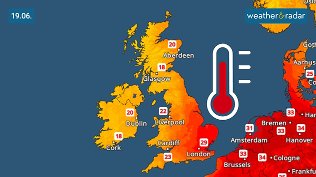
Temperature map of the UK and western Europe on 19.06 showing warm conditions across the UK, with temperatures reaching 29 °C near London, 23 °C around Cardiff, and 18 to 20 °C across Scotland and Ireland, alongside a large thermometer icon.
By Friday, daily highs are pushing 30 °C once again.

Heat health alerts have been issued for the second half of the week in parts of England as temperatures rise.

Issued by the UK Health Security Agency, amber alerts are active from Thursday in the south-east, south-west, and East Anglia. Yellow alerts are also live across the Midlands. Each running until Monday evening.

Did you know?

Heat health alerts are a joint venture by the Met Office and UKHSA from June to September and differ from extreme heat warnings by the Met Office only. In May, extraordinary alerts were issued for the early heatwave.

These alerts come in response to rising temperatures across the UK. Despite this, unsettled conditions remain in areas to the north and west lessening the impact.

In the areas under an alert, daily highs are expected to reach the upper-20s, possibly reaching 30 °C locally in the south-east and east of England with the threshold for an official heatwave likely to be met over the next week in the same areas.

Does El Niño have an impact here?read more
Ryan Hathaway

More on the topic

Overnight impacts as Austen hits. Power cuts, travel issues. . . Friday, 23 October 2026
Split image showing floodwater surging beneath a railway bridge at night and a wind map with low pressure over the English Channel and 60 mph near Brest.
Friday, 23 October 2026

Power cuts, travel issues

Overnight impacts as Austen hits
Severe weather risk in the Mediterranean. Turkey and Greece. . . Tuesday, 27 October 2026
Weather map showing low pressure over the Aegean Sea, blue rain bands across Greece and Turkey, and heavy rain and thunderstorm warning symbols.
Tuesday, 27 October 2026

Turkey and Greece

Severe weather risk in the Mediterranean
Calmer autumn views on a stormy week. Your weather - Your shots. . . Sunday, 25 October 2026
Split image showing swirling orange-pink sunset clouds above green countryside and golden wispy clouds over a tree-lined car park.
Sunday, 25 October 2026

Your weather - Your shots

Calmer autumn views on a stormy week
All weather news

This might also interest you

Storm Chandra makes impact. Severe gales & heavy rain. . . Tuesday, 27 January 2026
Split image showing strong winds over the UK on a forecast map and widespread rain and snow on a weather radar map.
Tuesday, 27 January 2026

Severe gales & heavy rain

Storm Chandra makes impact
Historic Storm Éowyn arrives. On this day.... . . Saturday, 24 January 2026
Split image showing a person in a yellow jacket struggling against strong winds and heavy rain on a street at night on the left, and an Irish wind forecast map on the right with red and purple shading, gusts up to 75 mph, and a wind warning icon, divided by a curved white line.
Saturday, 24 January 2026

On this day...

Historic Storm Éowyn arrives
A stormy week in the skies above. Your weather - Your shots. . . Sunday, 30 August 2026
Split image showing lightning branching beneath dark storm clouds above rooftops on the left and an orange-pink sunset over a calm sea on the right.
Sunday, 30 August 2026

Your weather - Your shots

A stormy week in the skies above
All articles
Weather & Radar

Weather & Radar is also available on

Google Play StoreApp Store

Company

Contact us Privacy Policy Legal info Accessibility statement

Services

Uploader

Socials

facebooktwittertikToklinkList