Home
Weather London
WeatherRadar
RainfallRadar
TemperatureRadar
WindRadar
LightningRadar
Weather News
Editor's Pick
Discover the app
Weather widget
Contact us
Apps
Career
    Home / Editor's Pick /

    Ahead of the World Cup kick-off: Tropical storm hits Mexico

12:00
8 June 2026

Ahead of the World Cup
Tropical storm hits Mexico

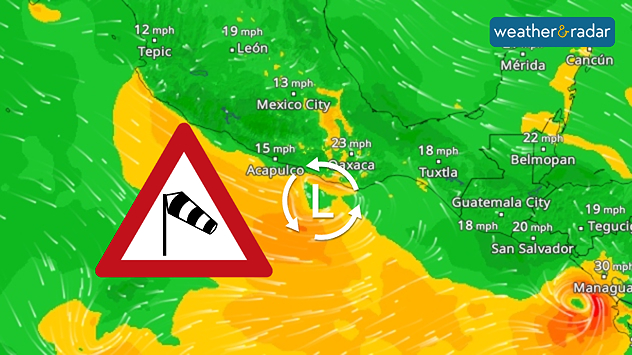
Ahead of the World Cup opening this week, a tropical storm has formed with impacts across Mexico.

A powerful low-pressure system has developed off the Mexican Pacific coast. It is set to hit southern Mexico during the night leading into Tuesday, bringing heavy rain.

Coastal towns such as Acapulco are expected to receive between 100 and 200 mm of rain, with some areas seeing as much as 300 mm locally.

WindRadar on Monday.

This poses a risk of flooding and mudslides, particularly in mountainous areas with winds picking up, bringing gusts along the coast.

A wet start to the World Cup

Things are looking turbulent for the start of the World Cup on Thursday as well. Thunderstorms are also expected for the opening match in Mexico City.

Over the past few days, there have been repeated torrential downpours, which have led to flooded roads.

Mexico City

Tu
14
25
We
15
24
Th
15
26
Fr
15
25
Sa
15
25
Su
15
26
Mo
14
23
Tu
14
23
We
14
22
Th
14
22
Fr
13
24
Sa
14
24
Su
14
24
Mo
14
25
Max (°C)
Min (°C)
moreless

Acapulco de Juárez

Tu
25
33
We
24
34
Th
24
34
Fr
25
35
Sa
26
35
Su
25
34
Mo
25
33
Tu
26
33
We
26
33
Th
26
34
Fr
25
33
Sa
25
33
Su
25
33
Mo
25
33
Max (°C)
Min (°C)
moreless

Scotland's first match will take place on Sunday in Foxborough, Massachusetts. Temperatures are expected to peak at 31 °C with sunny spells at the open-air Gillette Stadium.

Meanwhile, England kick off their World Cup next Thursday at the AT&T Stadium in Arlington, Texas. The early trend suggests a high at around 28 °C under cloudy skies.

Weather & Radar editorial team
More on the topic
Heavier rainfall over the week for some. Ireland & Scotland. . . Tuesday, 28 July 2026
Split image showing a Europe rainfall accumulation forecast map on the left with the highest totals across the UK, Ireland, and Scandinavia, and a satellite weather map on the right with a broad band of rain stretching across Ireland, Scotland, and northern Britain, highlighted by a rain cloud icon.
Tuesday, 28 July 2026

Ireland & Scotland

Heavier rainfall over the week for some
Drought for North Wales and Upper Severn. 2% of average rainfall. . . Thursday, 23 July 2026
Split image showing a July rainfall anomaly map of Europe on the left with below-average rainfall across the UK, Ireland, and much of western and central Europe, and an active moorland wildfire on the right producing flames and thick smoke near homes.
Thursday, 23 July 2026

2% of average rainfall

Drought for North Wales and Upper Severn
Heat becoming a bigger factor in drought. New study. . . Thursday, 23 July 2026
A hand holds dry, dusty earth above a parched field. The ground is cracked and covered with plant debris – a sign of prolonged drought.
Thursday, 23 July 2026

New study

Heat becoming a bigger factor in drought
All weather news
This might also interest you
Super Typhoon Bavi threatens Taiwan. Up to 1,000 mm of rain. . . Wednesday, 8 July 2026
The image shows an intense tropical cyclone over the western Pacific, east of Taiwan and the Philippines. The centre of the system is depicted as a light purple and white vortex with a clearly visible eye, surrounded by a ring of red and orange areas indicating the strongest wind speeds. A white arrow marks the typhoon’s predicted track towards the north-west, in the direction of Taiwan. To the west of the storm lie the Philippines, with the cities of Manila and Cebu; to the north of these lies Taiwan, with Taipei. Further west, the Chinese coast, including Hong Kong, and parts of Vietnam can be seen. The coloured wind map shows predominantly green areas outside the storm’s core, indicating significantly weaker winds. White streamlines illustrate the typhoon’s anti-clockwise circulation in the Northern Hemisphere. The highest wind speeds are concentrated around the eye of the cyclone.
Wednesday, 8 July 2026

Up to 1,000 mm of rain

Super Typhoon Bavi threatens Taiwan
Storm Chandra makes impact. Severe gales & heavy rain. . . Tuesday, 27 January 2026
Split image showing strong winds over the UK on a forecast map and widespread rain and snow on a weather radar map.
Tuesday, 27 January 2026

Severe gales & heavy rain

Storm Chandra makes impact
Flooding, gales, and heavy snow. Storm Chandra. . . Tuesday, 27 January 2026
Split image showing aerial flooding in a town with muddy water covering roads on the left, and a rural road on the right blocked by heavy snowfall with vans stopped and a person walking in snow.
Tuesday, 27 January 2026

Storm Chandra

Flooding, gales, and heavy snow
All articles
Weather & Radar

Weather & Radar is also available on

Google Play StoreApp Store

Company

Contact us Privacy Policy Legal info Accessibility statement

Services

Uploader

Socials

facebooktwittertikToklinkList