Home
Weather London
WeatherRadar
RainfallRadar
TemperatureRadar
WindRadar
LightningRadar
Weather News
Editor's Pick
Discover the app
Weather widget
Contact us
Apps
Career
    Home / Editor's Pick /

    After 2022 devastation: Hurricane names Fiona & Ian retired

08:00
31 March 2023

After 2022 devastation
Hurricane names Fiona & Ian retired

Hurricane damage
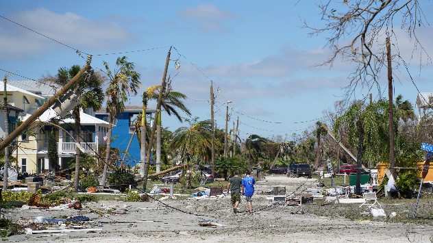
A scene of devastation in Fort Myers, Florida following Hurricane Ian. - © picture alliance

Both Fiona and Ian have been retired as hurricane names after causing multiple deaths and extensive damage in the US last year.

The World Meteorological Organisation has announced that the names will no longer be used, joining the 96 previously retired names.

It is common practice to retire the names of hurricanes which resulted in large-scale damages, almost all retired names were withdrawn following events causing billions of dollars in damage and multiple losses of life.

Hurricane Fiona resulted in approximately $3 billion in damages principally across the Caribbean where it impacted Puerto Rico and the Dominican Republic among others, and Canada last September.

Final figures suggest the hurricane was responsible for 29 deaths, peaking as a category 4 hurricane and becoming the most intense post-tropical cyclone to ever hit Canada.

In the system’s aftermath Puerto Rico, still recovering from Hurricane Maria, experienced widespread blackouts and severe flooding.

Extensive coverage of Hurricane Ian by Weather & Radar US

Hurricane Ian formed on September 23rd and would go on to become the deadliest system to hit Florida for over 80 years and the costliest ever.

Before reaching the US, Ian first impacted Cuba before intensifying en-route to Florida. It arrived as a category 4 system with sustained wind speeds of 150 mph leaving a trail of destruction.

At least 150 people were killed by, or as a result of, the system with Florida accounting for the majority of those reported.

Hurricane names are rotated annually and repeat every six years, from 2028 Fiona and Ian will be replaced by Farrah and Idris respectively.

Names are chosen by the World Meteorological Organisation and are used to help deliver information regarding severe events.

This year’s Atlantic hurricane season begins in June and will be kicked off by Hurricane Arlene.

Ryan Hathaway
More on the topic
Half of England now in drought. Joining North Wales. . . Wednesday, 29 July 2026
Dry section of the River Thames beneath a small stone bridge, with the riverbed exposed and cracked after prolonged, dry weather, while a person walks along the roadside above.
Wednesday, 29 July 2026

Joining North Wales

Half of England now in drought
Forest fires spread to south-east Europe. Heat and strong winds. . . Thursday, 30 July 2026
Split image showing an active wildfire with flames and thick smoke on the left, and a wind forecast map of Greece on the right with gusts of 25–35 mph around the Aegean Sea, alongside a wildfire warning symbol highlighting elevated fire danger.
Thursday, 30 July 2026

Heat and strong winds

Forest fires spread to south-east Europe
Icy spells in the Southern Hemisphere. Snow in the Andes. . . Tuesday, 28 July 2026
A composite image showing a temperature radar map of South America and a snow-covered town in Chile. The winter cold is bringing heavy snowfall to the Andes and, in some areas, snow down to lower altitudes.
Tuesday, 28 July 2026

Snow in the Andes

Icy spells in the Southern Hemisphere
All weather news
This might also interest you
Seasonal warmth between spring thunder. Your weather - Your shots. . . Sunday, 19 April 2026
Split image showing coastal sunset with layered lenticular clouds over rooftops and palm trees on the left, and a green valley with river and hills under soft daylight on the right.
Sunday, 19 April 2026

Your weather - Your shots

Seasonal warmth between spring thunder
Super Typhoon Bavi threatens Taiwan. Up to 1,000 mm of rain. . . Wednesday, 8 July 2026
The image shows an intense tropical cyclone over the western Pacific, east of Taiwan and the Philippines. The centre of the system is depicted as a light purple and white vortex with a clearly visible eye, surrounded by a ring of red and orange areas indicating the strongest wind speeds. A white arrow marks the typhoon’s predicted track towards the north-west, in the direction of Taiwan. To the west of the storm lie the Philippines, with the cities of Manila and Cebu; to the north of these lies Taiwan, with Taipei. Further west, the Chinese coast, including Hong Kong, and parts of Vietnam can be seen. The coloured wind map shows predominantly green areas outside the storm’s core, indicating significantly weaker winds. White streamlines illustrate the typhoon’s anti-clockwise circulation in the Northern Hemisphere. The highest wind speeds are concentrated around the eye of the cyclone.
Wednesday, 8 July 2026

Up to 1,000 mm of rain

Super Typhoon Bavi threatens Taiwan
Turbulent weather in the Canary Islands. Storm and rain. . . Friday, 12 December 2025
Weather graphic showing rain and wind fields over the Canary Islands and a central warning symbol.
Friday, 12 December 2025

Storm and rain

Turbulent weather in the Canary Islands
All articles
Weather & Radar

Weather & Radar is also available on

Google Play StoreApp Store

Company

Contact us Privacy Policy Legal info Accessibility statement

Services

Uploader

Socials

facebooktwittertikToklinkList