Home
Weather London
WeatherRadar
RainfallRadar
TemperatureRadar
WindRadar
LightningRadar
Weather News
Editor's Pick
Discover the app
Weather widget
Contact us
Apps
Career
    Home / Editor's Pick /

    Active jet stream – Storms follow one after another

09:00
17 February 2026

Active jet stream
Storms follow one after another

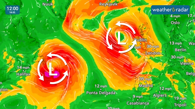
WindRadar shows two powerful storms over the Atlantic between North America and Europe.

The weather will remain turbulent over the next few days thanks to numerous storm fronts over the Atlantic.

One low-pressure system after another is sweeping across the ocean, reaching our shores and western Europe with strong winds and rain.

The jet stream, a band of strong winds at high altitude, is currently meandering particularly strongly and showing a pronounced wave pattern. Depending on the situation, the paths of the Atlantic lows veer further south or north.

As a result, the storm lows sometimes hit the UK, Ireland, and Scandinavia, other times Central Europe or even the Mediterranean region.

Very changeable weather in EuropeWeatherRadar

For the weather here and in Europe, this means an unstable and sometimes turbulent phase: powerful low-pressure systems with strong winds and sometimes heavy rain will repeatedly sweep across the continent. Calm high-pressure systems will find it difficult to prevail for long periods in this pattern.

Dennis Oswald
Ryan Hathaway

More on the topic

First major storm of the season. Storm Austen named. . . Tuesday, 20 October 2026
On the left, WindRadar shows a storm system over the UK with strong winds. On the right, high waves are crashing against a sea wall. A warning symbol indicates a storm.
Tuesday, 20 October 2026

Storm Austen named

First major storm of the season
Warnings live across the UK and Ireland. How do they work?. . . Tuesday, 20 October 2026
Weather warning map showing yellow and orange wind alerts across Ireland and England, with red level 3 areas in southwest England and a windsock symbol.
Tuesday, 20 October 2026

How do they work?

Warnings live across the UK and Ireland
Storm Austen approaches. What to expect tonight. . . Thursday, 22 October 2026
Split image showing a wind map with 65 mph near Brest and a swirling storm south of England, beside a man wearing glasses and holding a microphone.
Thursday, 22 October 2026

What to expect tonight

Storm Austen approaches
All weather news

This might also interest you

A frozen start to the weekend. Icy conditions. . . Friday, 13 February 2026
UK temperature map dated 14.02 showing widespread subzero values in blue shading, with readings such as −4 in Glasgow, −3 in Dublin, and −2 in London, alongside a blue thermometer icon.
Friday, 13 February 2026

Icy conditions

A frozen start to the weekend
New records for England and Wales. Broken again tomorrow?. . . Thursday, 25 June 2026
Temperature map of southwest Britain on 25.06 showing extreme heat across southern Wales and southwest England, with Bute Park in Cardiff highlighted at 34.2°C and Yeovilton at 36.4°C amid widespread deep red heat zones.
Thursday, 25 June 2026

Broken again tomorrow?

New records for England and Wales
Flooding, gales, and heavy snow. Storm Chandra. . . Tuesday, 27 January 2026
Split image showing aerial flooding in a town with muddy water covering roads on the left, and a rural road on the right blocked by heavy snowfall with vans stopped and a person walking in snow.
Tuesday, 27 January 2026

Storm Chandra

Flooding, gales, and heavy snow
All articles
Weather & Radar

Weather & Radar is also available on

Google Play StoreApp Store

Company

Contact us Privacy Policy Legal info Accessibility statement

Services

Uploader

Socials

facebooktwittertikToklinkList