Home
Weather London
WeatherRadar
RainfallRadar
TemperatureRadar
WindRadar
LightningRadar
Weather News
Editor's Pick
Discover the app
Weather widget
Contact us
Apps
Career
    Home / Editor's Pick /

    Active jet stream – Storms follow one after another

09:00
17 February 2026

Active jet stream
Storms follow one after another

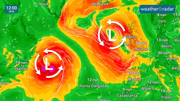
WindRadar shows two powerful storms over the Atlantic between North America and Europe.

The weather will remain turbulent over the next few days thanks to numerous storm fronts over the Atlantic.

One low-pressure system after another is sweeping across the ocean, reaching our shores and western Europe with strong winds and rain.

The jet stream, a band of strong winds at high altitude, is currently meandering particularly strongly and showing a pronounced wave pattern. Depending on the situation, the paths of the Atlantic lows veer further south or north.

As a result, the storm lows sometimes hit the UK, Ireland, and Scandinavia, other times Central Europe or even the Mediterranean region.

Very changeable weather in EuropeWeatherRadar

For the weather here and in Europe, this means an unstable and sometimes turbulent phase: powerful low-pressure systems with strong winds and sometimes heavy rain will repeatedly sweep across the continent. Calm high-pressure systems will find it difficult to prevail for long periods in this pattern.

Dennis Oswald
Ryan Hathaway
More on the topic
Weather warning map of Wales and western Britain showing a yellow thunderstorm alert with lightning symbols, alongside a large warning triangle for lightning.
Wednesday, 27 May 2026

Wales & western England

Thunderstorm watch continues
On the left is the temperature radar, showing high temperatures across Western Europe. On the right is the weather radar, showing a high-pressure system.
Tuesday, 26 May 2026

Summer weather in spring

Heatwave sets new records in Europe too
Heat map centered on London showing intense red temperatures across southeast England, with Heathrow highlighted at 33.5°C and nearby cities around 30–32°C.
Monday, 25 May 2026

33.5 °C and still rising

Hottest May day on record
All weather news
This might also interest you
Split image showing a person in a yellow jacket struggling against strong winds and heavy rain on a street at night on the left, and an Irish wind forecast map on the right with red and purple shading, gusts up to 75 mph, and a wind warning icon, divided by a curved white line.
Saturday, 24 January 2026

On this day...

Historic Storm Éowyn arrives
Split image showing coastal sunset with layered lenticular clouds over rooftops and palm trees on the left, and a green valley with river and hills under soft daylight on the right.
Sunday, 19 April 2026

Your weather - Your shots

Seasonal warmth between spring thunder
Weather graphic showing rain and wind fields over the Canary Islands and a central warning symbol.
Friday, 12 December 2025

Storm and rain

Turbulent weather in the Canary Islands
All articles
Weather & Radar

Weather & Radar is also available on

Google Play StoreApp Store

Company

Contact us Privacy Policy Legal info Accessibility statement

Services

Uploader

Socials

facebooktwittertikToklinkList