Home
Weather London
WeatherRadar
RainfallRadar
TemperatureRadar
WindRadar
LightningRadar
Weather News
Editor's Pick
Discover the app
Weather widget
Contact us
Apps
Career
    Home / Editor's Pick /

    Above-average warmth - Spring records for England & Wales

08:00
2 June 2026

Above-average warmth
Spring records for England & Wales

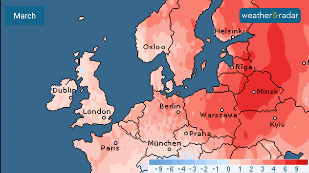
March temperature anomaly map of Europe showing widespread above-average temperatures in shades of red, strongest across eastern Europe and the Baltic region, with smaller anomalies over western Europe and the UK and Ireland.
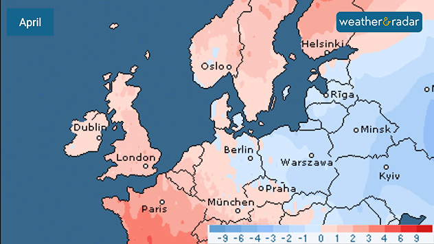
April temperature anomaly map of Europe showing warmer-than-average conditions in western Europe and Scandinavia in light red shades, while eastern Europe displays cooler-than-average anomalies in blue tones.
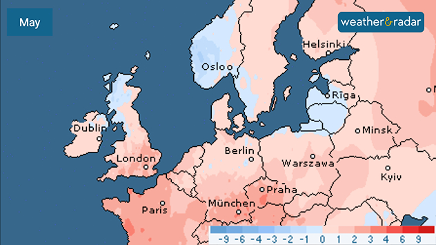
May temperature anomaly map of Europe showing mostly warmer-than-average conditions in light red shades across western and central Europe, with cooler blue anomalies over parts of the UK, Ireland, Scandinavia, and eastern Europe.
1/3
March's temperature anomaly map shows widespread above-average heat.

Spring has entered the history books as the warmest on record in England and Wales, becoming the third warmest across the UK.

Aided by May's late heatwave, with six conscutive days of temperatures over 30 °C, England and Wales saw the warmest spring season for mean temperature.

All three spring months also sit inside the top ten warmest for the UK since records began in 1884.

In England, this marks the third consecutive warmest spring with a mean temperature of 10.41 °C, beating the 2025 record of 10.23 °C.

Wales saw a mean temperature of 9.73 °C while Northern Ireland saw the sixth warmest season and Scotland the eighth, all combining for the third hottest spring for the UK as a whole.

Compounding the wamth was below-average rainfall, finishing 14% below the long-term spring average, though sunshine hours were above-average for all four countries.

Ryan Hathaway
More on the topic
Forest fires are getting out of control. Spain and France. . . Saturday, 25 July 2026
A split-screen image featuring a photograph and a weather map. On the left, thick, dark-grey smoke rises from several fire sites in a wooded coastal area; a calm stretch of water can be seen in the foreground. On the right, a weather map shows south-western France and northern Spain. A red arrow points from the Atlantic towards the French Atlantic coast, symbolising an onshore wind. Sunny weather is forecast for Bordeaux at around 20 degrees, and Bilbao is also expected to be sunny at around 27 degrees. A large warning sign with a flame symbol indicates an increased risk of forest fires.
Saturday, 25 July 2026

Spain and France

Forest fires are getting out of control
Icy spells in the Southern Hemisphere. Snow in the Andes. . . Tuesday, 28 July 2026
A composite image showing a temperature radar map of South America and a snow-covered town in Chile. The winter cold is bringing heavy snowfall to the Andes and, in some areas, snow down to lower altitudes.
Tuesday, 28 July 2026

Snow in the Andes

Icy spells in the Southern Hemisphere
Drought for North Wales and Upper Severn. 2% of average rainfall. . . Thursday, 23 July 2026
Split image showing a July rainfall anomaly map of Europe on the left with below-average rainfall across the UK, Ireland, and much of western and central Europe, and an active moorland wildfire on the right producing flames and thick smoke near homes.
Thursday, 23 July 2026

2% of average rainfall

Drought for North Wales and Upper Severn
All weather news
This might also interest you
Flooding, gales, and heavy snow. Storm Chandra. . . Tuesday, 27 January 2026
Split image showing aerial flooding in a town with muddy water covering roads on the left, and a rural road on the right blocked by heavy snowfall with vans stopped and a person walking in snow.
Tuesday, 27 January 2026

Storm Chandra

Flooding, gales, and heavy snow
Long-term trends need a pinch of salt. 40 °C in July?. . . Tuesday, 30 June 2026
Temperature radar of 2022 heatwave where the all-time temperature record in the UK was set. Warning symbol overlain.
Tuesday, 30 June 2026

40 °C in July?

Long-term trends need a pinch of salt
Historic Storm Éowyn arrives. On this day.... . . Saturday, 24 January 2026
Split image showing a person in a yellow jacket struggling against strong winds and heavy rain on a street at night on the left, and an Irish wind forecast map on the right with red and purple shading, gusts up to 75 mph, and a wind warning icon, divided by a curved white line.
Saturday, 24 January 2026

On this day...

Historic Storm Éowyn arrives
All articles
Weather & Radar

Weather & Radar is also available on

Google Play StoreApp Store

Company

Contact us Privacy Policy Legal info Accessibility statement

Services

Uploader

Socials

facebooktwittertikToklinkList