Home
Weather London
WeatherRadar
RainfallRadar
TemperatureRadar
WindRadar
LightningRadar
Weather News
Editor's Pick
Discover the app
Weather widget
Contact us
Apps
Career
    Home / Editor's Pick /

    A spell of cooler weather - Slow start to summer across Europe

10:00
1 June 2026

A spell of cooler weather
Slow start to summer across Europe

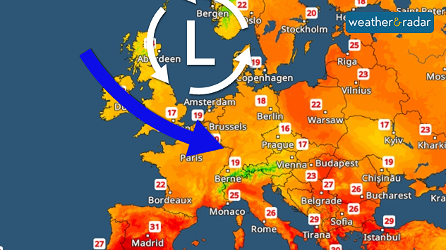
A low-pressure system is bringing cooler air from the North Atlantic to Europe this week.

June 1st marks the start of meteorological summer, however, in many parts of Europe, the new season is not really getting off to a fitting start.

After the heat of last week, it almost seems as though early summer has already run out of steam.

A low-pressure system is spreading from Iceland across the UK and Central Europe to the Balkans. Bringing with it several weather fronts with heavy showers and cooler air.

Temperatures north of Bordeaux as far as Budapest hardly rise above 25 degrees. On some days, regional daily highs remain well below the 20-degree mark.

A cooler spell in June is generally nothing out of the ordinary. It may just feel a little more prominent this time as it arrives fresh off of the late-spring heatwave which set a new May record-high temperature.

From the coming weekend, temperatures are likely to rise again as we head deeper into summer.

European weather: Frequent downpoursWeatherRadar
Weather & Radar editorial team
More on the topic
Heavier rainfall over the week for some. Ireland & Scotland. . . Tuesday, 28 July 2026
Split image showing a Europe rainfall accumulation forecast map on the left with the highest totals across the UK, Ireland, and Scandinavia, and a satellite weather map on the right with a broad band of rain stretching across Ireland, Scotland, and northern Britain, highlighted by a rain cloud icon.
Tuesday, 28 July 2026

Ireland & Scotland

Heavier rainfall over the week for some
Drought for North Wales and Upper Severn. 2% of average rainfall. . . Thursday, 23 July 2026
Split image showing a July rainfall anomaly map of Europe on the left with below-average rainfall across the UK, Ireland, and much of western and central Europe, and an active moorland wildfire on the right producing flames and thick smoke near homes.
Thursday, 23 July 2026

2% of average rainfall

Drought for North Wales and Upper Severn
Rain returns to end dry spell in places. Jet stream delivery. . . Thursday, 23 July 2026
Split weather graphic showing widespread showers across the UK and Ireland on the left, and a wind forecast map on the right with a windsock icon and gusts of 25 to 35 mph, highlighting breezy conditions across the two countries.
Thursday, 23 July 2026

Jet stream delivery

Rain returns to end dry spell in places
All weather news
This might also interest you
Long-term trends need a pinch of salt. 40 °C in July?. . . Tuesday, 30 June 2026
Temperature radar of 2022 heatwave where the all-time temperature record in the UK was set. Warning symbol overlain.
Tuesday, 30 June 2026

40 °C in July?

Long-term trends need a pinch of salt
Flooding, gales, and heavy snow. Storm Chandra. . . Tuesday, 27 January 2026
Split image showing aerial flooding in a town with muddy water covering roads on the left, and a rural road on the right blocked by heavy snowfall with vans stopped and a person walking in snow.
Tuesday, 27 January 2026

Storm Chandra

Flooding, gales, and heavy snow
Seasonal warmth between spring thunder. Your weather - Your shots. . . Sunday, 19 April 2026
Split image showing coastal sunset with layered lenticular clouds over rooftops and palm trees on the left, and a green valley with river and hills under soft daylight on the right.
Sunday, 19 April 2026

Your weather - Your shots

Seasonal warmth between spring thunder
All articles
Weather & Radar

Weather & Radar is also available on

Google Play StoreApp Store

Company

Contact us Privacy Policy Legal info Accessibility statement

Services

Uploader

Socials

facebooktwittertikToklinkList