Home
Weather London
WeatherRadar
RainfallRadar
TemperatureRadar
WindRadar
LightningRadar
Weather News
Editor's Pick
Discover the app
Weather widget
Contact us
Apps
Career
    Home / Editor's Pick /

    A heatwave is on the way in Europe – is El Niño to blame?

07:13
16 June 2026

Is El Niño to blame?
A heatwave is on the way in Europe

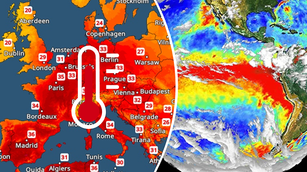
Split image showing a Europe temperature map with widespread red heatwave conditions and temperatures above 30 C on the left, and an El Niño ocean temperature anomaly map of the Pacific Ocean on the right with a broad band of unusually warm water along the equator.
Will El Niño impact temperatures here? - © picture alliance

A heatwave is building once again across Europe. At the same time, the El Niño weather phenonmenon has formed over the eastern Pacific. Is there a link?

Despite some reports, the answer to this question is a resounding no. Although the onset of the El Niño phenomenon has now been officially confirmed, its effects are essentially limited to regions in and around the Pacific Ocean.

Did you know?

The El Niño weather phenomenon recurs every two to seven years with varying intensities. Initial calculations suggest that the El Niño event currently getting underway is likely to be particularly strong. 

This is particularly noticeable in South America and South-East Asia. As a result, increased flooding, heatwaves and droughts are expected there in the coming months. But in California and parts of Mexico, too, the weather could literally go haywire due to El Niño.

In contrast, the heatwave currently sweeping across south-western Europe has nothing to do with El Niño. Rather, a summer "heat dome" has formed over Spain, which is now slowly spreading towards Central Europe.

In fact, the heat in Spain and France is likely to intensify even further as the weekend approaches: maximum temperatures of around 40 °C, or even higher, are expected there.

Learn more about El Niño and the El Niño Southern Oscillation.

Weather & Radar editorial team
More on the topic
Severe weather in the Mediterranean. Is a medicane on the way?. . . Monday, 14 September 2026
A weather map shows a powerful low-pressure system over the Mediterranean, with warning symbols for storms and heavy rain.
Monday, 14 September 2026

Is a medicane on the way?

Severe weather in the Mediterranean
Severe weather hits Mallorca and Italy. Severe thunderstorms. . . Thursday, 10 September 2026
Numerous thunderstorms are sweeping across La Palma. The many lightning symbols on the radar and lightning map show that there is heavy lightning activity across large parts of the island. The thunderstorms are striking particularly in the island’s interior and in the south. On the right, you can see the aftermath: a large fallen tree has buried a car beneath it. Emergency services are clearing up the damage. So, along with the thunderstorms, not only heavy rain but also gusts of wind can become a problem.
Thursday, 10 September 2026

Severe thunderstorms

Severe weather hits Mallorca and Italy
Record ocean heat halting hurricanes. Strong El Niño influence. . . Friday, 11 September 2026
A weather map shows a calm Atlantic Ocean with no hurricanes, alongside a picture of the sea.
Friday, 11 September 2026

Strong El Niño influence

Record ocean heat halting hurricanes
All weather news
This might also interest you
Historic Storm Éowyn arrives. On this day.... . . Saturday, 24 January 2026
Split image showing a person in a yellow jacket struggling against strong winds and heavy rain on a street at night on the left, and an Irish wind forecast map on the right with red and purple shading, gusts up to 75 mph, and a wind warning icon, divided by a curved white line.
Saturday, 24 January 2026

On this day...

Historic Storm Éowyn arrives
Flooding, gales, and heavy snow. Storm Chandra. . . Tuesday, 27 January 2026
Split image showing aerial flooding in a town with muddy water covering roads on the left, and a rural road on the right blocked by heavy snowfall with vans stopped and a person walking in snow.
Tuesday, 27 January 2026

Storm Chandra

Flooding, gales, and heavy snow
New records for England and Wales. Broken again tomorrow?. . . Thursday, 25 June 2026
Temperature map of southwest Britain on 25.06 showing extreme heat across southern Wales and southwest England, with Bute Park in Cardiff highlighted at 34.2°C and Yeovilton at 36.4°C amid widespread deep red heat zones.
Thursday, 25 June 2026

Broken again tomorrow?

New records for England and Wales
All articles
Weather & Radar

Weather & Radar is also available on

Google Play StoreApp Store

Company

Contact us Privacy Policy Legal info Accessibility statement

Services

Uploader

Socials

facebooktwittertikToklinkList