Home
Weather London
WeatherRadar
RainfallRadar
TemperatureRadar
WindRadar
LightningRadar
Weather News
Editor's Pick
Discover the app
Weather widget
Contact us
Apps
Career
    Home / Editor's Pick /

    A heatwave is on the way in Europe – is El Niño to blame?

07:13
16 June 2026

Is El Niño to blame?
A heatwave is on the way in Europe

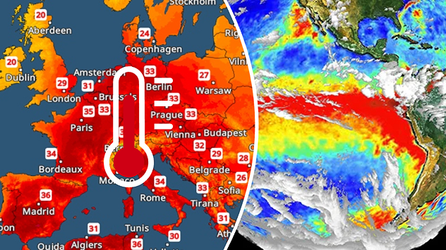
Split image showing a Europe temperature map with widespread red heatwave conditions and temperatures above 30 C on the left, and an El Niño ocean temperature anomaly map of the Pacific Ocean on the right with a broad band of unusually warm water along the equator.
Will El Niño impact temperatures here? - © picture alliance

A heatwave is building once again across Europe. At the same time, the El Niño weather phenonmenon has formed over the eastern Pacific. Is there a link?

Despite some reports, the answer to this question is a resounding no. Although the onset of the El Niño phenomenon has now been officially confirmed, its effects are essentially limited to regions in and around the Pacific Ocean.

Did you know?

The El Niño weather phenomenon recurs every two to seven years with varying intensities. Initial calculations suggest that the El Niño event currently getting underway is likely to be particularly strong. 

This is particularly noticeable in South America and South-East Asia. As a result, increased flooding, heatwaves and droughts are expected there in the coming months. But in California and parts of Mexico, too, the weather could literally go haywire due to El Niño.

In contrast, the heatwave currently sweeping across south-western Europe has nothing to do with El Niño. Rather, a summer "heat dome" has formed over Spain, which is now slowly spreading towards Central Europe.

In fact, the heat in Spain and France is likely to intensify even further as the weekend approaches: maximum temperatures of around 40 °C, or even higher, are expected there.

Learn more about El Niño and the El Niño Southern Oscillation.

Weather & Radar editorial team
More on the topic
Sea fog rolls into Pembrokeshire. Unique summer scene. . . Tuesday, 14 July 2026
Thick sea fog rolling inland over a sunlit bay, with sparkling water, trees and garden in the foreground, and a hill rising above the fog under a clear blue sky.
Tuesday, 14 July 2026

Unique summer scene

Sea fog rolls into Pembrokeshire
Violent storms impacting northern Italy. Hail and storm damage. . . Thursday, 16 July 2026
A weather map showing thunderstorms over northern Italy and a photograph of large hailstones in a hand.
Thursday, 16 July 2026

Hail and storm damage

Violent storms impacting northern Italy
The monsoon has India firmly in its grip. Severe thunderstorms. . . Thursday, 9 July 2026
Satellite map of South Asia showing the weather situation over India. An arrow marks a low-pressure system over western and central India, which is causing heavy showers and thunderstorms. Thick clouds and rainfall extend across large parts of India as far as the Himalayas and into Bangladesh. Over Pakistan and south-eastern Iran, however, it is mainly sunny and hot, with temperatures exceeding 40 degrees.
Thursday, 9 July 2026

Severe thunderstorms

The monsoon has India firmly in its grip
All weather news
This might also interest you
Historic Storm Éowyn arrives. On this day.... . . Saturday, 24 January 2026
Split image showing a person in a yellow jacket struggling against strong winds and heavy rain on a street at night on the left, and an Irish wind forecast map on the right with red and purple shading, gusts up to 75 mph, and a wind warning icon, divided by a curved white line.
Saturday, 24 January 2026

On this day...

Historic Storm Éowyn arrives
Turbulent weather in the Canary Islands. Storm and rain. . . Friday, 12 December 2025
Weather graphic showing rain and wind fields over the Canary Islands and a central warning symbol.
Friday, 12 December 2025

Storm and rain

Turbulent weather in the Canary Islands
Seasonal warmth between spring thunder. Your weather - Your shots. . . Sunday, 19 April 2026
Split image showing coastal sunset with layered lenticular clouds over rooftops and palm trees on the left, and a green valley with river and hills under soft daylight on the right.
Sunday, 19 April 2026

Your weather - Your shots

Seasonal warmth between spring thunder
All articles
Weather & Radar

Weather & Radar is also available on

Google Play StoreApp Store

Company

Contact us Privacy Policy Legal info Accessibility statement

Services

Uploader

Socials

facebooktwittertikToklinkList