Home
Weather London
WeatherRadar
RainfallRadar
TemperatureRadar
WindRadar
LightningRadar
Weather News
Editor's Pick
Discover the app
Weather widget
Contact us
Apps
Career
    Home / Editor's Pick /

    A changeable month: What can we expect in April?

15:00
1 April 2023

A changeable month
What can we expect in April?

April

It's the start of a brand new month, but what kind of weather can we expect throughout April?

Throughout April, daylight hours continue to increase, with us gaining nearly two hours of daylight by the end of the month.

As for temperatures, average highs tend to be around 12C early April, but remain cooler in the early mornings and evenings, still with the chance of a late-season frost.

While the average remains in the low double digits in terms of temperature, we have seen the mercury soar into the high-twenties previously. A monthly high of 29.4C was recorded on 16th April 1949, and more recently, 29.1C on the 19th in 2018.

April is however expected to be a changeable month. Just under half the month is expected to have sunny or partly sunny skies, though the rest of the month is expected to see some rainfall.

Snow is still possible in April, though accumulating snow tends to be rare, due to the strength of the sun and the warmth in the ground at this time of year.

We've had a quiet storm season thus far and April doesn't tend to see particularly stormy conditions either. However April 2019 saw the arrival of Storm Hannah, one of the most significant April storms in the last 50 years.

April 2021 had its lowest average minimum temperatures since 1922, with 14 days of air frost on average across the UK and 22 days of ground frost unfortunately for gardeners. This also came after a March ending in the mid-twenties!

April 2022 on the other hand, saw temperatures rise to 23.4C after a chilly start to the month. So, how will April 2023 fare?

Well, it looks as though high pressure is doing its best to build in through the first part of the month, with temperatures around or a little below average. Be weary of your tender plants under clear, calm conditions though!

Average last frost datesread more
Weather & Radar editorial team
More on the topic
More rain needed to ease drought. Reservoirs still falling. . . Tuesday, 8 September 2026
Aerial view of a depleted reservoir with exposed banks and a narrow winding stream through the dry basin, surrounded by green hills and roads.
Tuesday, 8 September 2026

Reservoirs still falling

More rain needed to ease drought
Hottest summer on record for Ireland. Beating 2025's record. . . Thursday, 3 September 2026
Temperature map of Ireland showing 29°C in Dublin, 26°C in Cork, 24°C in Belfast, and 23°C in Galway, with a red thermometer icon.
Thursday, 3 September 2026

Beating 2025's record

Hottest summer on record for Ireland
Severe weather hits Mallorca and Italy. Severe thunderstorms. . . Thursday, 10 September 2026
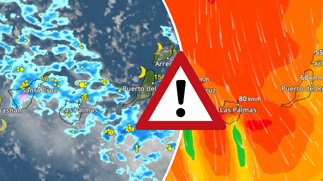
Numerous thunderstorms are sweeping across La Palma. The many lightning symbols on the radar and lightning map show that there is heavy lightning activity across large parts of the island. The thunderstorms are striking particularly in the island’s interior and in the south. On the right, you can see the aftermath: a large fallen tree has buried a car beneath it. Emergency services are clearing up the damage. So, along with the thunderstorms, not only heavy rain but also gusts of wind can become a problem.
Thursday, 10 September 2026

Severe thunderstorms

Severe weather hits Mallorca and Italy
All weather news
This might also interest you
A stormy week in the skies above. Your weather - Your shots. . . Sunday, 30 August 2026
Split image showing lightning branching beneath dark storm clouds above rooftops on the left and an orange-pink sunset over a calm sea on the right.
Sunday, 30 August 2026

Your weather - Your shots

A stormy week in the skies above
Long-term trends need a pinch of salt. 40 °C in July?. . . Tuesday, 30 June 2026
Temperature radar of 2022 heatwave where the all-time temperature record in the UK was set. Warning symbol overlain.
Tuesday, 30 June 2026

40 °C in July?

Long-term trends need a pinch of salt
Storm Chandra makes impact. Severe gales & heavy rain. . . Tuesday, 27 January 2026
Split image showing strong winds over the UK on a forecast map and widespread rain and snow on a weather radar map.
Tuesday, 27 January 2026

Severe gales & heavy rain

Storm Chandra makes impact
All articles
Weather & Radar

Weather & Radar is also available on

Google Play StoreApp Store

Company

Contact us Privacy Policy Legal info Accessibility statement

Services

Uploader

Socials

facebooktwittertikToklinkList