Home
Weather London
WeatherRadar
RainfallRadar
TemperatureRadar
WindRadar
LightningRadar
Weather News
Editor's Pick
Discover the app
Weather widget
Contact us
Apps
Career
    Home /

    Weekend weather - Split remains with 30°C in sight again

16:38
7 August 2026

Weekend weather
Split remains with 30°C in sight again

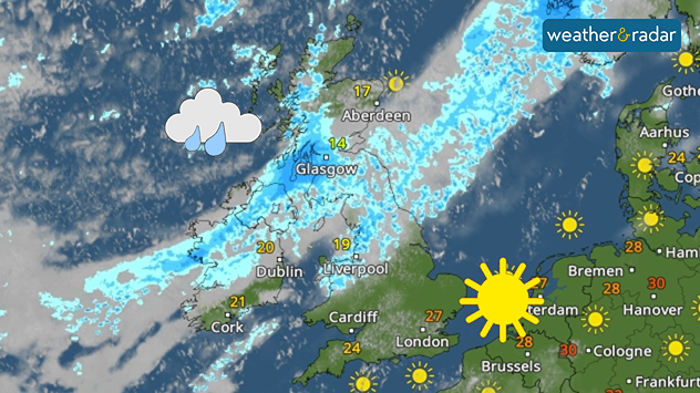
Weather radar of the UK and Ireland showing a broad rain band from Ireland through Scotland and northern England, while southern England has sunny spells. Temperatures range from 14°C in Glasgow to 27°C near London.
A common sight on Sunday with conditions split across the UK and Ireland.

This coming weekend brings little change to the dominating pattern of our weather story in recent weeks, temperatures rise in the south-east again with more unsettled conditions in the north-west.

Saturday sees largely warm and dry weather across southern Wales into south-east England with light winds offering a gentle cooling too.

Yet again spells of rain and showers cross over Ireland, Scotland, and the north-west of England. Temperatures see a north-south split too with highs of around 15°C in the north of Scotland and around 27°C in south-east England.

Into Sunday cloud cover masks much of Ireland away from brighter spells in the south with heavier rainfall across the north into Northern Ireland and Scotland again.

Away from the cloud and rain, temperatures are passing the 30°C mark again for parts of England and Wales. Highs of around 33°C are possible locally in the south and east of England with plenty of sunshine.

It remains mostly sunny, dry, and warm into the new week ahead of another potential heatwave towards the latter end of the week.

London

Fr
14
26
Sa
14
27
Su
16
30
Mo
19
27
Tu
17
28
We
18
29
Th
21
33
Fr
23
33
Sa
22
30
Su
19
27
Mo
18
26
Tu
16
25
We
16
24
Th
15
25
Max (°C)
Min (°C)
moreless

Manchester

Fr
9
21
Sa
9
25
Su
13
21
Mo
14
21
Tu
12
28
We
17
30
Th
19
27
Fr
18
26
Sa
17
25
Su
15
23
Mo
14
22
Tu
14
21
We
12
20
Th
11
20
Max (°C)
Min (°C)
moreless

Dublin

Fr
11
22
Sa
11
22
Su
17
20
Mo
13
19
Tu
12
23
We
16
25
Th
16
25
Fr
17
24
Sa
14
21
Su
13
21
Mo
13
21
Tu
12
19
We
10
19
Th
10
19
Max (°C)
Min (°C)
moreless

Edinburgh

Fr
12
19
Sa
12
20
Su
14
18
Mo
11
19
Tu
11
21
We
12
27
Th
17
23
Fr
17
22
Sa
15
20
Su
13
19
Mo
12
20
Tu
13
19
We
11
19
Th
10
18
Max (°C)
Min (°C)
moreless

Cardiff

Fr
8
23
Sa
10
25
Su
13
25
Mo
15
25
Tu
16
29
We
18
32
Th
19
27
Fr
18
26
Sa
18
26
Su
16
24
Mo
16
23
Tu
15
22
We
13
21
Th
13
21
Max (°C)
Min (°C)
moreless
Weather & Radar editorial team
More on the topic
Huge hailstones in Poland. Severe weather hits towns. . . Friday, 7 August 2026
Friday, 7 August 2026

Severe weather hits towns

Huge hailstones in Poland
Vibrant skies for the last week of July. Your weather - Your shots. . . Sunday, 2 August 2026
Split image showing a golden-orange countryside sunset with silhouetted trees and birds on the left, and glowing blue-white noctilucent clouds rippling across the twilight sky above trees and a lake on the right.
Sunday, 2 August 2026

Your weather - Your shots

Vibrant skies for the last week of July
Stronger winds make a return. Low pressure influence. . . Tuesday, 4 August 2026
Wind forecast map of the UK and Ireland showing a low-pressure system north of Scotland, a windsock icon highlighting blustery conditions, and widespread winds of 30–40 mph across the British Isles, with the strongest winds around Ireland and northern Britain.
Tuesday, 4 August 2026

Low pressure influence

Stronger winds make a return
All weather news
This might also interest you
Icy spells in the Southern Hemisphere. Snow in the Andes. . . Tuesday, 28 July 2026
A composite image showing a temperature radar map of South America and a snow-covered town in Chile. The winter cold is bringing heavy snowfall to the Andes and, in some areas, snow down to lower altitudes.
Tuesday, 28 July 2026

Snow in the Andes

Icy spells in the Southern Hemisphere
Forest fires spread to south-east Europe. Heat and strong winds. . . Thursday, 30 July 2026
Split image showing an active wildfire with flames and thick smoke on the left, and a wind forecast map of Greece on the right with gusts of 25–35 mph around the Aegean Sea, alongside a wildfire warning symbol highlighting elevated fire danger.
Thursday, 30 July 2026

Heat and strong winds

Forest fires spread to south-east Europe
Catastrophic forest fires in Europe. Thousands evacuated. . . Monday, 27 July 2026
A composite image showing a temperature map of south-western Europe and a drone shot of a forest fire near Cap Ferret. A warning symbol featuring a flame indicates the increased risk of forest fires.
Monday, 27 July 2026

Thousands evacuated

Catastrophic forest fires in Europe
All articles
Weather & Radar

Weather & Radar is also available on

Google Play StoreApp Store

Company

Contact us Privacy Policy Legal info Accessibility statement

Services

Uploader

Socials

facebooktwittertikToklinkList