Home
Weather London
WeatherRadar
RainfallRadar
TemperatureRadar
WindRadar
LightningRadar
Weather News
Editor's Pick
Discover the app
Weather widget
Contact us
Apps
Career
    Home / Editor's Pick /

    Wettest week in England for two years

15:23
29 October 2026

Stormy assistance
Wettest week in England for two years

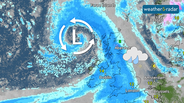
Weather map showing a swirling Atlantic low north-west of Scotland, with blue rain bands across the UK, Ireland, and North Sea and temperatures of 8 to 14°C
Storm Boelo helped fuel the wettest week in England for two years.

Storms Austen and Boelo helped deliver the wettest week in two years, according to provisional data from the Environment Agency.

Between Wednesday, October 21st and Tuesday, October 27th, an average of 55 mm of rainfall accumulated across England. Most notably, the south-west saw 87 mm within the week, marking the wettest reporting week since October 2024.

River flows increased at all but two of the Environment Agency's reporting sites compared to the previous week with rainfall across England as a whole now 111% of the long-term average for October.

Despite the heavy rain, it is not enough to lift drought conditions which still cover much of the country, with a severe drought status still covering swathes of the south-west.

The autumn and winter months provide time for reservoirs and groundwater to replenish, but with three droughts in five years, the period of recovery is increasingly no longer sufficient before the next summer arrives, especially increasingly hotter ones.

For now, a more settled period appears to be on the horizon as high-pressure takes over. Keep an eye on showers via the WeatherRadar, but more sustained rainfall is beginning to move away again.

Ryan Hathaway

More on the topic

Cyclone Arnab makes landfall in India. 100,000 people evacuated. . . Wednesday, 28 October 2026
Split weather maps showing an intense cyclone off India's east coast near Visakhapatnam, with red-purple wind zones, heavy blue rain and warning symbols.
Wednesday, 28 October 2026

100,000 people evacuated

Cyclone Arnab makes landfall in India
Widespread fog grips Thursday morning. Take care on the roads. . . Wednesday, 28 October 2026
Split image showing a fog forecast across southern England with temperatures of 8–9°C, alongside cars driving through dense mist on a sunlit road.
Wednesday, 28 October 2026

Take care on the roads

Widespread fog grips Thursday morning
Severe weather risk in the Mediterranean. Turkey and Greece. . . Tuesday, 27 October 2026
Weather map showing low pressure over the Aegean Sea, blue rain bands across Greece and Turkey, and heavy rain and thunderstorm warning symbols.
Tuesday, 27 October 2026

Turkey and Greece

Severe weather risk in the Mediterranean
All weather news

This might also interest you

Flooding, gales, and heavy snow. Storm Chandra. . . Tuesday, 27 January 2026
Split image showing aerial flooding in a town with muddy water covering roads on the left, and a rural road on the right blocked by heavy snowfall with vans stopped and a person walking in snow.
Tuesday, 27 January 2026

Storm Chandra

Flooding, gales, and heavy snow
Long-term trends need a pinch of salt. 40 °C in July?. . . Tuesday, 30 June 2026
Temperature radar of 2022 heatwave where the all-time temperature record in the UK was set. Warning symbol overlain.
Tuesday, 30 June 2026

40 °C in July?

Long-term trends need a pinch of salt
Historic Storm Éowyn arrives. On this day.... . . Saturday, 24 January 2026
Split image showing a person in a yellow jacket struggling against strong winds and heavy rain on a street at night on the left, and an Irish wind forecast map on the right with red and purple shading, gusts up to 75 mph, and a wind warning icon, divided by a curved white line.
Saturday, 24 January 2026

On this day...

Historic Storm Éowyn arrives
All articles
Weather & Radar

Weather & Radar is also available on

Google Play StoreApp Store

Company

Contact us Privacy Policy Legal info Accessibility statement

Services

Uploader

Socials

facebooktwittertikToklinkList