Home
Weather London
WeatherRadar
RainfallRadar
TemperatureRadar
WindRadar
LightningRadar
Weather News
Editor's Pick
Discover the app
Weather widget
Contact us
Apps
Career
    Home /

    Weather Trend

15:34
16 November 2026

Weather Trend
A very mixed few days ahead

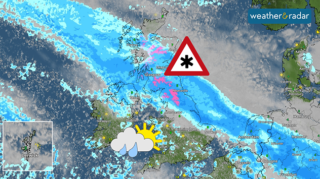
Bands of rain and hill snow move through on Tuesday

An unsettled week ahead, but will there be a break in the rain for your weekend plans?

There’s plenty of autumn weather on the way this week, with spells of rain, blustery winds and even some snow in the forecast. If you’re planning to spend time outdoors, keeping an eye on the forecast could make all the difference.

Atlantic weather systems bring a return to wetter and windier conditions. Tuesday looks particularly unsettled, with heavy showers in the south and more persistent rain further north. Some snow is also possible over higher ground for a time.

Wednesday brings a mix of showers and sunny spells with mild air in the south, while Thursday could offer some better opportunities to get outside, particularly across northern areas where conditions turn brighter.

Friday looks set to be dry for many with good sunny spells and just a few coastal showers.

Looking ahead to Saturday and Sunday, the weather is expected to become more changeable again as further Atlantic systems are approaching. However, eastern areas could hold on to the drier weather for longer.

London

Mo
4
8
Tu
5
13
We
9
13
Th
7
10
Fr
7
9
Sa
0
9
Su
8
11
Mo
8
10
Tu
6
10
We
5
8
Th
5
8
Fr
5
9
Sa
6
9
Su
4
7
Max (°C)
Min (°C)
moreless

Manchester

Mo
-2
6
Tu
3
8
We
6
10
Th
6
7
Fr
-1
7
Sa
-1
6
Su
5
9
Mo
5
8
Tu
5
9
We
4
7
Th
4
7
Fr
3
6
Sa
4
6
Su
3
7
Max (°C)
Min (°C)
moreless

Dublin

Mo
-1
8
Tu
8
11
We
8
11
Th
4
10
Fr
2
9
Sa
3
11
Su
8
10
Mo
6
10
Tu
5
9
We
5
8
Th
5
9
Fr
6
10
Sa
3
8
Su
3
9
Max (°C)
Min (°C)
moreless

Edinburgh

Mo
-1
6
Tu
1
5
We
5
7
Th
5
7
Fr
-1
6
Sa
-1
5
Su
4
8
Mo
4
7
Tu
4
7
We
3
6
Th
2
6
Fr
1
5
Sa
3
5
Su
4
6
Max (°C)
Min (°C)
moreless

Cardiff

Mo
0
8
Tu
5
12
We
9
12
Th
6
10
Fr
3
9
Sa
2
10
Su
7
11
Mo
7
10
Tu
5
10
We
4
8
Th
3
8
Fr
2
8
Sa
4
9
Su
2
8
Max (°C)
Min (°C)
moreless
Lars Lowinski

More on the topic

Storm hits the Iberian Peninsula. Hurricane-force gusts. . . Wednesday, 11 November 2026
WindRadar showing a storm warning symbol and areas of strong winds over Portugal, southern Spain and Morocco.
Wednesday, 11 November 2026

Hurricane-force gusts

Storm hits the Iberian Peninsula
Summer heat in the middle of November. Unusual temperatures. . . Tuesday, 10 November 2026
The weather map shows the temperatures in south-eastern Europe and the Mediterranean region. It is particularly warm in the Balkans: temperatures in Belgrade are reaching 25 degrees. A red arrow indicates that warm air is flowing from the central Mediterranean towards Serbia. In Italy, Greece and Romania, too, temperatures are above 20 degrees in many places. By contrast, it is significantly cooler in the Alps and in parts of Central Europe.
Tuesday, 10 November 2026

Unusual temperatures

Summer heat in the middle of November
A foggy start to a frosty end. Your weather - Your shots. . . Sunday, 15 November 2026
Split image showing a calm lake shrouded in dense gray fog beside terraced houses beneath textured purple-gray sunset clouds.
Sunday, 15 November 2026

Your weather - Your shots

A foggy start to a frosty end
All weather news

This might also interest you

Europe set for a change in the weather. Turning more unsettled. . . Monday, 9 November 2026
European weather map showing low pressure over Scandinavia, pink snow bands across Norway and Sweden, blue rain areas and arrows indicating airflow.
Monday, 9 November 2026

Turning more unsettled

Europe set for a change in the weather
Blocking high brings anticyclonic gloom. Overcast days. . . Tuesday, 3 November 2026
Split weather maps showing widespread cloud across the UK and Ireland alongside a high-pressure system centred over Britain, with isobars near 1035 hPa.
Tuesday, 3 November 2026

Overcast days

Blocking high brings anticyclonic gloom
Further fog disruption expected. Growing dense overnight. . . Monday, 9 November 2026
Weather map showing widespread fog across the English Midlands, with a red fog warning symbol near Nottingham and temperatures of 4–6°C.
Monday, 9 November 2026

Growing dense overnight

Further fog disruption expected
All articles
Weather & Radar

Weather & Radar is also available on

Google Play StoreApp Store

Company

Contact us Privacy Policy Legal info Accessibility statement

Services

Uploader

Socials

facebooktwittertikToklinkList