Home
Weather London
WeatherRadar
RainfallRadar
TemperatureRadar
WindRadar
LightningRadar
Weather News
Editor's Pick
Discover the app
Weather widget
Contact us
Apps
Career
    Home / Editor's Pick /

    Cooler nights on the horizon – temperatures as low as 10 degrees in some regions

09:50
6 August 2026

For parts of Europe
Cooler nights on the horizon

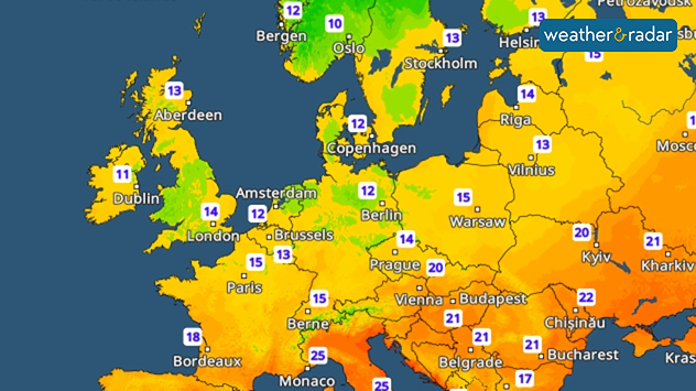
After the sweltering nights of recent days, many people across Europe can finally breathe a sigh of relief with temperatures are dropping noticeably at night.

Cooler nights are coming particularly in Western and Central Europe, and later on in Eastern Central Europe as well.

This makes it much easier to air the home in the mornings and evenings. In many places, temperatures will drop to a pleasant 18 to 12°C. From northern France through northern Germany to eastern Poland, temperatures will at times even drop to 10°C.

It will remain cooler in many places overnight into Saturday. Dropping to 10°C or below in parts.

But that doesn’t mean summer is quite over yet. During the day, it remains warm to hot in many regions. However, the cooler nights give our bodies a chance to catch their breath. Many of us also find it easier to sleep again.

Nights are cooler here tooread more
Weather & Radar editorial team
More on the topic
Vibrant skies for the last week of July. Your weather - Your shots. . . Sunday, 2 August 2026
Split image showing a golden-orange countryside sunset with silhouetted trees and birds on the left, and glowing blue-white noctilucent clouds rippling across the twilight sky above trees and a lake on the right.
Sunday, 2 August 2026

Your weather - Your shots

Vibrant skies for the last week of July
Forest fires spread to south-east Europe. Heat and strong winds. . . Thursday, 30 July 2026
Split image showing an active wildfire with flames and thick smoke on the left, and a wind forecast map of Greece on the right with gusts of 25–35 mph around the Aegean Sea, alongside a wildfire warning symbol highlighting elevated fire danger.
Thursday, 30 July 2026

Heat and strong winds

Forest fires spread to south-east Europe
Stronger winds make a return. Low pressure influence. . . Tuesday, 4 August 2026
Wind forecast map of the UK and Ireland showing a low-pressure system north of Scotland, a windsock icon highlighting blustery conditions, and widespread winds of 30–40 mph across the British Isles, with the strongest winds around Ireland and northern Britain.
Tuesday, 4 August 2026

Low pressure influence

Stronger winds make a return
All weather news
This might also interest you
A frozen start to the weekend. Icy conditions. . . Friday, 13 February 2026
UK temperature map dated 14.02 showing widespread subzero values in blue shading, with readings such as −4 in Glasgow, −3 in Dublin, and −2 in London, alongside a blue thermometer icon.
Friday, 13 February 2026

Icy conditions

A frozen start to the weekend
Storm Chandra makes impact. Severe gales & heavy rain. . . Tuesday, 27 January 2026
Split image showing strong winds over the UK on a forecast map and widespread rain and snow on a weather radar map.
Tuesday, 27 January 2026

Severe gales & heavy rain

Storm Chandra makes impact
Flooding, gales, and heavy snow. Storm Chandra. . . Tuesday, 27 January 2026
Split image showing aerial flooding in a town with muddy water covering roads on the left, and a rural road on the right blocked by heavy snowfall with vans stopped and a person walking in snow.
Tuesday, 27 January 2026

Storm Chandra

Flooding, gales, and heavy snow
All articles
Weather & Radar

Weather & Radar is also available on

Google Play StoreApp Store

Company

Contact us Privacy Policy Legal info Accessibility statement

Services

Uploader

Socials

facebooktwittertikToklinkList