Home
Weather London
WeatherRadar
RainfallRadar
TemperatureRadar
WindRadar
LightningRadar
Weather News
Editor's Pick
Discover the app
Weather widget
Contact us
Apps
Career
    Home / Editor's Pick /

    2% of average rainfall - Drought for North Wales and Upper Severn

14:43
23 July 2026

2% of average rainfall
Drought for North Wales and Upper Severn

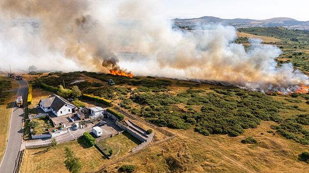
Wildfire burns in field behind home in the countryside.
Wildfires burn in Flintshire, North Wales amid heatwaves and drought. - © picture alliance / Visually | DGDImages

North Wales and Upper Severn are officially in drought, after multiple heatwaves, very little rainfall, and record-low river levels.

Natural Resources Wales (NRW) confirmed the status on Thursday, which also impacts a part of the English West Midlands through the Upper Severn.

Other areas under the drought declaration are: North Gwynedd, South Gwynedd, Ynys Môn, Dee, and Clwyd.

The change comes just days after 13 areas were declared as being in the midst of "prolonged dry weather." One step below a drought with the National Drought Group saying that just 13% of rivers across the UK are at normal levels.

In Wales, NRW say that this month could become the driest July in Wales for almost 190 years. In North Wales and the Upper Severn, just 2% of the average July rainfall has been received.

While there is some rain incoming over the weekend, it will not be heavy, nor prolonged enough, to make a big difference in the situation.

Heat becoming bigger factor in droughtread more
Ryan Hathaway

More on the topic

Heavy rain again in the south of France. Another bout of disruption. . . Wednesday, 4 November 2026
Split image showing heavy rain and lightning near Montpellier, Marseille and Monaco on a weather map, alongside cars stranded on a flooded road.
Wednesday, 4 November 2026

Another bout of disruption

Heavy rain again in the south of France
Europe set for a change in the weather. Turning more unsettled. . . Monday, 9 November 2026
European weather map showing low pressure over Scandinavia, pink snow bands across Norway and Sweden, blue rain areas and arrows indicating airflow.
Monday, 9 November 2026

Turning more unsettled

Europe set for a change in the weather
Europe caught between winter and summer. Frost and warmth. . . Friday, 6 November 2026
Temperature Radar showing freezing temperatures in northern and eastern Europe and temperatures above 20 degrees in Spain.
Friday, 6 November 2026

Frost and warmth

Europe caught between winter and summer
All weather news

This might also interest you

Flooding, gales, and heavy snow. Storm Chandra. . . Tuesday, 27 January 2026
Split image showing aerial flooding in a town with muddy water covering roads on the left, and a rural road on the right blocked by heavy snowfall with vans stopped and a person walking in snow.
Tuesday, 27 January 2026

Storm Chandra

Flooding, gales, and heavy snow
Historic Storm Éowyn arrives. On this day.... . . Saturday, 24 January 2026
Split image showing a person in a yellow jacket struggling against strong winds and heavy rain on a street at night on the left, and an Irish wind forecast map on the right with red and purple shading, gusts up to 75 mph, and a wind warning icon, divided by a curved white line.
Saturday, 24 January 2026

On this day...

Historic Storm Éowyn arrives
Storm Chandra makes impact. Severe gales & heavy rain. . . Tuesday, 27 January 2026
Split image showing strong winds over the UK on a forecast map and widespread rain and snow on a weather radar map.
Tuesday, 27 January 2026

Severe gales & heavy rain

Storm Chandra makes impact
All articles
Weather & Radar

Weather & Radar is also available on

Google Play StoreApp Store

Company

Contact us Privacy Policy Legal info Accessibility statement

Services

Uploader

Socials

facebooktwittertikToklinkList