Home
Weather London
WeatherRadar
RainfallRadar
TemperatureRadar
WindRadar
LightningRadar
Weather News
Editor's Pick
Discover the app
Weather widget
Contact us
Apps
Career
    Home / Editor's Pick /

    2% of average rainfall - Drought for North Wales and Upper Severn

14:43
23 July 2026

2% of average rainfall
Drought for North Wales and Upper Severn

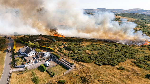
Wildfire burns in field behind home in the countryside.
Wildfires burn in Flintshire, North Wales amid heatwaves and drought. - © picture alliance / Visually | DGDImages

North Wales and Upper Severn are officially in drought, after multiple heatwaves, very little rainfall, and record-low river levels.

Natural Resources Wales (NRW) confirmed the status on Thursday, which also impacts a part of the English West Midlands through the Upper Severn.

Other areas under the drought declaration are: North Gwynedd, South Gwynedd, Ynys Môn, Dee, and Clwyd.

The change comes just days after 13 areas were declared as being in the midst of "prolonged dry weather." One step below a drought with the National Drought Group saying that just 13% of rivers across the UK are at normal levels.

In Wales, NRW say that this month could become the driest July in Wales for almost 190 years. In North Wales and the Upper Severn, just 2% of the average July rainfall has been received.

While there is some rain incoming over the weekend, it will not be heavy, nor prolonged enough, to make a big difference in the situation.

Heat becoming bigger factor in droughtread more
Ryan Hathaway
More on the topic
Catastrophic forest fires in Europe. Thousands evacuated. . . Monday, 27 July 2026
A composite image showing a temperature map of south-western Europe and a drone shot of a forest fire near Cap Ferret. A warning symbol featuring a flame indicates the increased risk of forest fires.
Monday, 27 July 2026

Thousands evacuated

Catastrophic forest fires in Europe
Clouds return to capture the scene. Your weather - Your shots. . . Sunday, 26 July 2026
Waxing crescent Moon above vivid pink and magenta sunset clouds, with silhouetted trees along the horizon beneath a deepening blue twilight sky.
Sunday, 26 July 2026

Your weather - Your shots

Clouds return to capture the scene
Icy spells in the Southern Hemisphere. Snow in the Andes. . . Tuesday, 28 July 2026
A composite image showing a temperature radar map of South America and a snow-covered town in Chile. The winter cold is bringing heavy snowfall to the Andes and, in some areas, snow down to lower altitudes.
Tuesday, 28 July 2026

Snow in the Andes

Icy spells in the Southern Hemisphere
All weather news
This might also interest you
Bright and warm conditions take hold. Spring-like outlook. . . Thursday, 23 April 2026
Split UK map showing warm temperatures up to 21 degrees in orange on the left and clear sunny conditions with temperatures from 12 to 18 degrees on the right, with sun icons across the country.
Thursday, 23 April 2026

Spring-like outlook

Bright and warm conditions take hold
A frozen start to the weekend. Icy conditions. . . Friday, 13 February 2026
UK temperature map dated 14.02 showing widespread subzero values in blue shading, with readings such as −4 in Glasgow, −3 in Dublin, and −2 in London, alongside a blue thermometer icon.
Friday, 13 February 2026

Icy conditions

A frozen start to the weekend
Super Typhoon Bavi threatens Taiwan. Up to 1,000 mm of rain. . . Wednesday, 8 July 2026
The image shows an intense tropical cyclone over the western Pacific, east of Taiwan and the Philippines. The centre of the system is depicted as a light purple and white vortex with a clearly visible eye, surrounded by a ring of red and orange areas indicating the strongest wind speeds. A white arrow marks the typhoon’s predicted track towards the north-west, in the direction of Taiwan. To the west of the storm lie the Philippines, with the cities of Manila and Cebu; to the north of these lies Taiwan, with Taipei. Further west, the Chinese coast, including Hong Kong, and parts of Vietnam can be seen. The coloured wind map shows predominantly green areas outside the storm’s core, indicating significantly weaker winds. White streamlines illustrate the typhoon’s anti-clockwise circulation in the Northern Hemisphere. The highest wind speeds are concentrated around the eye of the cyclone.
Wednesday, 8 July 2026

Up to 1,000 mm of rain

Super Typhoon Bavi threatens Taiwan
All articles
Weather & Radar

Weather & Radar is also available on

Google Play StoreApp Store

Company

Contact us Privacy Policy Legal info Accessibility statement

Services

Uploader

Socials

facebooktwittertikToklinkList