Home
Weather London
WeatherRadar
RainfallRadar
TemperatureRadar
WindRadar
LightningRadar
Weather News
Editor's Pick
Discover the app
Weather widget
Contact us
Apps
Career
    Home / Editor's Pick /

    Blocking high brings anticyclonic gloom

15:00
3 November 2026

Overcast days
Blocking high brings anticyclonic gloom

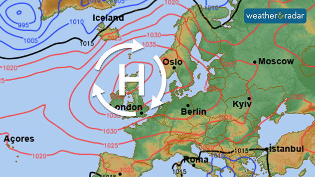
Synoptic weather map showing high pressure over the UK and western Europe, with a large H symbol and red isobars indicating 1030–1035 hPa.
A blocking high hangs over the UK and Ireland for much of this week.

High pressure is in control, and this often brings bright, clear skies, but not at the moment. The system overhead is known as a blocking high.

A blocking high is a persistent area of high pressure that can lead to stagnant weather conditions, often referred to as "anticyclonic gloom."

This phenomenon typically occurs when the high pressure becomes stationary, preventing the usual movement of weather systems.

As a blocking high establishes itself over the UK and Ireland, it can sometimes creates clear skies and dry weather in the short term, or, as it is now, trap cloud inside.

It can also exacerbate air quality issues, as pollution becomes trapped under the stable atmosphere. You can keep an eye on that with our app's Air Quality Index feature, though for now conditions are good and the pressure system is steadily moving towards Europe over the coming days.

Cloudy few days on the radarWeatherRadar
Ryan Hathaway

More on the topic

Staying fairly blustery across Ireland. Autumn greetings. . . Thursday, 29 October 2026
Wind map showing 35 mph winds near Galway and Cork, 25 mph near Dublin and Belfast, and lighter winds across western Britain, with a windsock symbol.
Thursday, 29 October 2026

Autumn greetings

Staying fairly blustery across Ireland
Cyclone Arnab makes landfall in India. 100,000 people evacuated. . . Wednesday, 28 October 2026
Split weather maps showing an intense cyclone off India's east coast near Visakhapatnam, with red-purple wind zones, heavy blue rain and warning symbols.
Wednesday, 28 October 2026

100,000 people evacuated

Cyclone Arnab makes landfall in India
Severe weather risk at holiday spots. Across the Mediterranean. . . Friday, 30 October 2026
Weather Radar shows a risk of flooding in Greece and Turkey. Meanwhile, the Wind Radar shows a storm system off Sicily with gusts of up to 50 miles per hour.
Friday, 30 October 2026

Across the Mediterranean

Severe weather risk at holiday spots
All weather news

This might also interest you

Historic Storm Éowyn arrives. On this day.... . . Saturday, 24 January 2026
Split image showing a person in a yellow jacket struggling against strong winds and heavy rain on a street at night on the left, and an Irish wind forecast map on the right with red and purple shading, gusts up to 75 mph, and a wind warning icon, divided by a curved white line.
Saturday, 24 January 2026

On this day...

Historic Storm Éowyn arrives
Bright and warm conditions take hold. Spring-like outlook. . . Thursday, 23 April 2026
Split UK map showing warm temperatures up to 21 degrees in orange on the left and clear sunny conditions with temperatures from 12 to 18 degrees on the right, with sun icons across the country.
Thursday, 23 April 2026

Spring-like outlook

Bright and warm conditions take hold
Super Typhoon Bavi threatens Taiwan. Up to 1,000 mm of rain. . . Wednesday, 8 July 2026
The image shows an intense tropical cyclone over the western Pacific, east of Taiwan and the Philippines. The centre of the system is depicted as a light purple and white vortex with a clearly visible eye, surrounded by a ring of red and orange areas indicating the strongest wind speeds. A white arrow marks the typhoon’s predicted track towards the north-west, in the direction of Taiwan. To the west of the storm lie the Philippines, with the cities of Manila and Cebu; to the north of these lies Taiwan, with Taipei. Further west, the Chinese coast, including Hong Kong, and parts of Vietnam can be seen. The coloured wind map shows predominantly green areas outside the storm’s core, indicating significantly weaker winds. White streamlines illustrate the typhoon’s anti-clockwise circulation in the Northern Hemisphere. The highest wind speeds are concentrated around the eye of the cyclone.
Wednesday, 8 July 2026

Up to 1,000 mm of rain

Super Typhoon Bavi threatens Taiwan
All articles
Weather & Radar

Weather & Radar is also available on

Google Play StoreApp Store

Company

Contact us Privacy Policy Legal info Accessibility statement

Services

Uploader

Socials

facebooktwittertikToklinkList