Home
Weather London
WeatherRadar
RainfallRadar
TemperatureRadar
WindRadar
LightningRadar
Weather News
Editor's Pick
Discover the app
Weather widget
Contact us
Apps
Career
    Home / Editor's Pick /

    212.9 mph wind gusts: Typhoon Koinu breaks records in Taiwan

10:15
5 October 2023

212.9 mph wind gusts
Typhoon Koinu breaks records in Taiwan

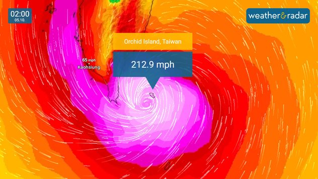
WindRadar showing Typhoon Koinu over Taiwan's Lanyu Island
Orchid Island saw the strongest wind gust ever recorded in Taiwan this morning.

Taiwan has provisionally recorded the strongest wind gust ever recorded in Asia, and the third strongest in the world, as Typhoon Koinu made impact overnight.

More than 300 people have been injured as Koinu brushed by the southern tip of Taiwan in the early hours, with one casualty reported.

A wind gust recorded at 212.9 mph on Taiwan's Orchid Island has provisionally become the strongest ever recorded in the country since records started, and the third strongest in the world.

The gust was so powerful it destroyed the island's anemometer as it passed.

Only speeds of 231 mph in New Hampshire, USA, and 253 mph on Australia's Barrow Island stand above last night's gusts internationally. While still offshore, the system saw sustained wind speeds of 130 mph, equivalent to a category 4 hurricane.

More than 60,000 properties lost power in the conditions, predominantly across Taiwan's western coast.

Felled tree on property
Tree blocking road
Closed bridge
Waves hit protective walls
1/4
Felled trees have resulted in property damage seen in Dawu, Taiwan. - © picture alliance

Heavy rainfall from the system fell mostly in mountainous regions, sparing more densely populated zones, although many cities in the south and east saw businesses and schools close ahead of Koinu's arrival.

Not a regular occurance

Koinu marks the second typhoon to make landfall in Taiwan this year, following Typhoon Haikui in September after a four-year break.

Koinu has now moved to the west of Taiwan, with western regions still seeing strong winds and rainfall.

It will continue moving west before likely making landfall in China in the early hours of Saturday.

Ryan Hathaway
More on the topic
Heavier rainfall over the week for some. Ireland & Scotland. . . Tuesday, 28 July 2026
Split image showing a Europe rainfall accumulation forecast map on the left with the highest totals across the UK, Ireland, and Scandinavia, and a satellite weather map on the right with a broad band of rain stretching across Ireland, Scotland, and northern Britain, highlighted by a rain cloud icon.
Tuesday, 28 July 2026

Ireland & Scotland

Heavier rainfall over the week for some
Typhoon warning for China. Up to 500 mm of rain. . . Friday, 24 July 2026
Weather map of the southern Chinese coast and Taiwan showing a powerful tropical cyclone. The eye of the storm is located near the coastal city of Shantou in the Chinese province of Guangdong. Around the centre, intense shades of red, pink and violet indicate gale-force winds, whilst a large orange wind field extends as far as the west coast of Taiwan. An overlaid windsack warning sign indicates dangerous storm winds. Cities such as Hong Kong, Guangzhou, Xiamen, Taipei and Taichung are shown, as are wind speeds and white flow lines illustrating the cyclonic air circulation.
Friday, 24 July 2026

Up to 500 mm of rain

Typhoon warning for China
Clouds return to capture the scene. Your weather - Your shots. . . Sunday, 26 July 2026
Waxing crescent Moon above vivid pink and magenta sunset clouds, with silhouetted trees along the horizon beneath a deepening blue twilight sky.
Sunday, 26 July 2026

Your weather - Your shots

Clouds return to capture the scene
All weather news
This might also interest you
A frozen start to the weekend. Icy conditions. . . Friday, 13 February 2026
UK temperature map dated 14.02 showing widespread subzero values in blue shading, with readings such as −4 in Glasgow, −3 in Dublin, and −2 in London, alongside a blue thermometer icon.
Friday, 13 February 2026

Icy conditions

A frozen start to the weekend
Turbulent weather in the Canary Islands. Storm and rain. . . Friday, 12 December 2025
Weather graphic showing rain and wind fields over the Canary Islands and a central warning symbol.
Friday, 12 December 2025

Storm and rain

Turbulent weather in the Canary Islands
Seasonal warmth between spring thunder. Your weather - Your shots. . . Sunday, 19 April 2026
Split image showing coastal sunset with layered lenticular clouds over rooftops and palm trees on the left, and a green valley with river and hills under soft daylight on the right.
Sunday, 19 April 2026

Your weather - Your shots

Seasonal warmth between spring thunder
All articles
Weather & Radar

Weather & Radar is also available on

Google Play StoreApp Store

Company

Contact us Privacy Policy Legal info Accessibility statement

Services

Uploader

Socials

facebooktwittertikToklinkList