Home
Weather London
WeatherRadar
RainfallRadar
TemperatureRadar
WindRadar
LightningRadar
Weather News
Editor's Pick
Discover the app
Weather widget
Contact us
Apps
Career
    Home / Editor's Pick /

    2024 predictions: Will this summer be a hot one?

06:00
26 May 2024

2024 predictions
Will this summer be a hot one?

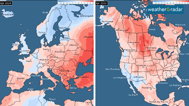
April 2024 temperature anomalies. Both Europe and North America had its second warmest April on record.

With 2024 projected to be another record breaker of a year, just how much merit does that statement hold?

The year is already off to a warm start with April 2024 coming in as the 11th month in a row to be the hottest on record.

2024 may be first year to hit 1.5°C of warming (relative to the global above average temperature from 1991-2020). Last year February 2023 to January 2024 reached this threshold, though it wasn't quite the entire calendar year of 2023.

First year-long breach of 1.5°Cread more

Can you accurately predict the summer already?

In short, no. We can look at overall trends for regions during a given month in the near future, but that will just be an average for the whole month, and doesn't account for any brief but extreme swings or fluctuations.

For example we can say that July 2024 is looking above-average for much of Europe, particularly Spain, however that could just be a few days of hot weather that skew the average, followed by roughly around or below-average temperatures.

So how is it looking?

Across Europe it currently looks like June, July and August are all trending above-average in terms of temperature, with a greater focus on southern and eastern Europe as hot spots.

In terms of pressure and precipitation, which are also important factors, June looks more low pressure dominated, with around average rainfall expected particularly for western Europe.

July is forecast to see above average rainfall in the south, with drier, high pressure dominated conditions in the east. August looks to see generally drier and more settled weather across the bulk of Europe.

What factors play a part?

How ENSO impacts us worldwide

The El Niño Southern Oscillation is a recurring climate phenomenon crucial in determining global weather and temperature patterns.

We're currently in an ENSO neutral phase with El Niño warning, forecast to remain neutral for the start of the summer at least. There are signs of La Niña possible later, with a greater risk from August in particular.

When El Niño is in play, higher global temperatures are generally expected, but with a neutral phase it may not have too much weight.

That being said, despite El Niño continuing to weaken in the eastern equatorial Pacific in recent months, high air and ocean temperatures have been persisting regardless. There are some instances when the ocean can look like it is in an El Niño or La Niña state, despite not actually being.

Climate change is also another factor to explore. The global-average temperature for the past twelve months, April 2023 to March 2024, is the highest on record, at 0.70°C above the 1991-2020 average.

The last 10 years have also been the 10 warmest on record, with most of the Earth's warming occurring in the last 40 years.

Increasing concentrations of atmospheric greenhouse gases will also continue to push the global temperature towards new temperature records.

More on the topic
Cooler nights on the horizon. For parts of Europe. . . Thursday, 6 August 2026
Temperature Radar showing the night-time lows in Central Europe. Cooler air is reaching the west and north in particular, whilst the south-east remains significantly warmer.
Thursday, 6 August 2026

For parts of Europe

Cooler nights on the horizon
Solar eclipse on Wednesday. Save the date. . . Monday, 10 August 2026
People are watching a solar eclipse. The sun is already partially obscured. Next to it is the weather radar forecast for Wednesday, showing an almost cloudless sky.
Monday, 10 August 2026

Save the date

Solar eclipse on Wednesday
Getting through the latest heatwave. Tips to beat the heat. . . Tuesday, 11 August 2026
Split graphic showing temperatures up to 35°C in England and 28°C in Ireland beside a person applying sunscreen, with a heat warning symbol highlighting hot weather.
Tuesday, 11 August 2026

Tips to beat the heat

Getting through the latest heatwave
All weather news
This might also interest you
Historic Storm Éowyn arrives. On this day.... . . Saturday, 24 January 2026
Split image showing a person in a yellow jacket struggling against strong winds and heavy rain on a street at night on the left, and an Irish wind forecast map on the right with red and purple shading, gusts up to 75 mph, and a wind warning icon, divided by a curved white line.
Saturday, 24 January 2026

On this day...

Historic Storm Éowyn arrives
Super Typhoon Bavi threatens Taiwan. Up to 1,000 mm of rain. . . Wednesday, 8 July 2026
The image shows an intense tropical cyclone over the western Pacific, east of Taiwan and the Philippines. The centre of the system is depicted as a light purple and white vortex with a clearly visible eye, surrounded by a ring of red and orange areas indicating the strongest wind speeds. A white arrow marks the typhoon’s predicted track towards the north-west, in the direction of Taiwan. To the west of the storm lie the Philippines, with the cities of Manila and Cebu; to the north of these lies Taiwan, with Taipei. Further west, the Chinese coast, including Hong Kong, and parts of Vietnam can be seen. The coloured wind map shows predominantly green areas outside the storm’s core, indicating significantly weaker winds. White streamlines illustrate the typhoon’s anti-clockwise circulation in the Northern Hemisphere. The highest wind speeds are concentrated around the eye of the cyclone.
Wednesday, 8 July 2026

Up to 1,000 mm of rain

Super Typhoon Bavi threatens Taiwan
Long-term trends need a pinch of salt. 40 °C in July?. . . Tuesday, 30 June 2026
Temperature radar of 2022 heatwave where the all-time temperature record in the UK was set. Warning symbol overlain.
Tuesday, 30 June 2026

40 °C in July?

Long-term trends need a pinch of salt
All articles
Weather & Radar

Weather & Radar is also available on

Google Play StoreApp Store

Company

Contact us Privacy Policy Legal info Accessibility statement

Services

Uploader

Socials

facebooktwittertikToklinkList