Home
Weather London
WeatherRadar
RainfallRadar
TemperatureRadar
WindRadar
LightningRadar
Weather News
Editor's Pick
Discover the app
Weather widget
Contact us
Apps
Career
    Home / Editor's Pick /

    2024 predictions: Will this summer be a hot one?

06:00
26 May 2024

2024 predictions
Will this summer be a hot one?

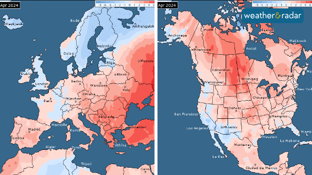
April 2024 temperature anomalies. Both Europe and North America had its second warmest April on record.

With 2024 projected to be another record breaker of a year, just how much merit does that statement hold?

The year is already off to a warm start with April 2024 coming in as the 11th month in a row to be the hottest on record.

2024 may be first year to hit 1.5°C of warming (relative to the global above average temperature from 1991-2020). Last year February 2023 to January 2024 reached this threshold, though it wasn't quite the entire calendar year of 2023.

First year-long breach of 1.5°Cread more

Can you accurately predict the summer already?

In short, no. We can look at overall trends for regions during a given month in the near future, but that will just be an average for the whole month, and doesn't account for any brief but extreme swings or fluctuations.

For example we can say that July 2024 is looking above-average for much of Europe, particularly Spain, however that could just be a few days of hot weather that skew the average, followed by roughly around or below-average temperatures.

So how is it looking?

Across Europe it currently looks like June, July and August are all trending above-average in terms of temperature, with a greater focus on southern and eastern Europe as hot spots.

In terms of pressure and precipitation, which are also important factors, June looks more low pressure dominated, with around average rainfall expected particularly for western Europe.

July is forecast to see above average rainfall in the south, with drier, high pressure dominated conditions in the east. August looks to see generally drier and more settled weather across the bulk of Europe.

What factors play a part?

How ENSO impacts us worldwide

The El Niño Southern Oscillation is a recurring climate phenomenon crucial in determining global weather and temperature patterns.

We're currently in an ENSO neutral phase with El Niño warning, forecast to remain neutral for the start of the summer at least. There are signs of La Niña possible later, with a greater risk from August in particular.

When El Niño is in play, higher global temperatures are generally expected, but with a neutral phase it may not have too much weight.

That being said, despite El Niño continuing to weaken in the eastern equatorial Pacific in recent months, high air and ocean temperatures have been persisting regardless. There are some instances when the ocean can look like it is in an El Niño or La Niña state, despite not actually being.

Climate change is also another factor to explore. The global-average temperature for the past twelve months, April 2023 to March 2024, is the highest on record, at 0.70°C above the 1991-2020 average.

The last 10 years have also been the 10 warmest on record, with most of the Earth's warming occurring in the last 40 years.

Increasing concentrations of atmospheric greenhouse gases will also continue to push the global temperature towards new temperature records.

More on the topic
Severe weather in southern Europe. Thunderstorms & heavy rain. . . Wednesday, 9 September 2026
On the left, dark storm clouds over a coastline. On the right, a weather map shows thunderstorms over the western Mediterranean, with warning symbols for tornadoes, storms and hail.
Wednesday, 9 September 2026

Thunderstorms & heavy rain

Severe weather in southern Europe
Hottest summer on record for Ireland. Beating 2025's record. . . Thursday, 3 September 2026
Temperature map of Ireland showing 29°C in Dublin, 26°C in Cork, 24°C in Belfast, and 23°C in Galway, with a red thermometer icon.
Thursday, 3 September 2026

Beating 2025's record

Hottest summer on record for Ireland
Extreme weather contrasts in Europe. Heat versus constant rain. . . Thursday, 3 September 2026
On the left, the Temperature Radar shows high temperatures in Spain; on the right, the Weather Radar shows rain in Central Europe
Thursday, 3 September 2026

Heat versus constant rain

Extreme weather contrasts in Europe
All weather news
This might also interest you
Flooding, gales, and heavy snow. Storm Chandra. . . Tuesday, 27 January 2026
Split image showing aerial flooding in a town with muddy water covering roads on the left, and a rural road on the right blocked by heavy snowfall with vans stopped and a person walking in snow.
Tuesday, 27 January 2026

Storm Chandra

Flooding, gales, and heavy snow
New records for England and Wales. Broken again tomorrow?. . . Thursday, 25 June 2026
Temperature map of southwest Britain on 25.06 showing extreme heat across southern Wales and southwest England, with Bute Park in Cardiff highlighted at 34.2°C and Yeovilton at 36.4°C amid widespread deep red heat zones.
Thursday, 25 June 2026

Broken again tomorrow?

New records for England and Wales
A frozen start to the weekend. Icy conditions. . . Friday, 13 February 2026
UK temperature map dated 14.02 showing widespread subzero values in blue shading, with readings such as −4 in Glasgow, −3 in Dublin, and −2 in London, alongside a blue thermometer icon.
Friday, 13 February 2026

Icy conditions

A frozen start to the weekend
All articles
Weather & Radar

Weather & Radar is also available on

Google Play StoreApp Store

Company

Contact us Privacy Policy Legal info Accessibility statement

Services

Uploader

Socials

facebooktwittertikToklinkList