Home
Weather London
WeatherRadar
RainfallRadar
TemperatureRadar
WindRadar
LightningRadar
Weather News
Editor's Pick
Discover the app
Weather widget
Contact us
Apps
Career
    Home / Editor's Pick /

    200+ warnings in place: Storm Babet: Flooding still a danger

11:00
23 October 2023

200+ warnings in place
Storm Babet: Flooding still a danger

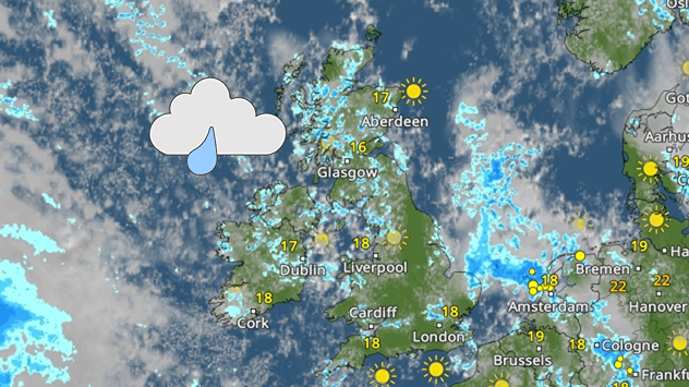
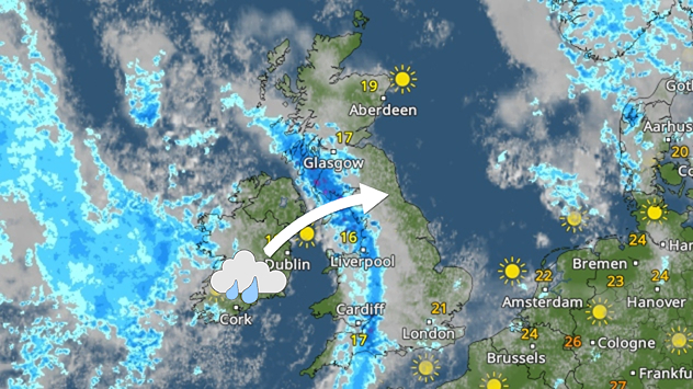
WeatherRadar showing rain over the UK and Ireland with flood warning sign
Storm Babet has departed but fresh rain, seen Tuesday on the WeatherRadar, and rising river levels prompt new flood warnings.

Flooding could last until midweek, the Environment Agency says, with seven people now confirmed to have passed away due to Storm Babet.

More than 200 flood warnings and alerts remain in place across England on Monday, with bodies of water still at elevated levels and more rainfall expected on Tuesday.

Areas around the River Severn are at an elevated risk of floods according to the Environment Agency, with parts of the East Midlands, and Yorkshire and the Humber also likely to see flooding as river levels continue to rise.

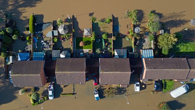
Flooded properties drone shot
River flooding
Flood defences along River Severn
Flooded fields
1/4
Properties in evacuated Retford, Nottinghamshire were flooded on Sunday. - © picture alliance

Storm Babet has now dissipated, and weather warnings are not currently in force. More than 1,250 properties have been flooded in England so far, while in Scotland some roads, including the A90, remain shut as engineers work on repairs.

Friday's Storm Babet live blogread more

All flood warnings in Scotland have now been lifted, though the effects of the storm will remain for months. Some residents of evacuated Brechin have been told they could be permanently removed from their homes due to the damage.

On Sunday, Derbyshire Police announced that a woman in her 80s had passed away in Chesterfield, bringing the current total to seven. Officers believe the cause of death to be related to the flooding.

Privacy Policy

In Ireland, flooding has been reported in County Cork as a train of persistent rain falls over the country on Monday. This band of rain pushes east into the UK overnight.

Further temporary flood defences have been deployed across at-risk areas of England in a bid to prevent the worst-case scenario for continued flooding this week.

See conditions at any time on the WeatherRadar.

Ryan Hathaway
More on the topic
Cheshire Gap produces shower funnel. Local phenomenon. . . Wednesday, 9 September 2026
Weather map showing showers moving southeast from Liverpool toward Birmingham, driven by Cheshire Gap convergence across central England.
Wednesday, 9 September 2026

Local phenomenon

Cheshire Gap produces shower funnel
Hottest summer on record for Ireland. Beating 2025's record. . . Thursday, 3 September 2026
Temperature map of Ireland showing 29°C in Dublin, 26°C in Cork, 24°C in Belfast, and 23°C in Galway, with a red thermometer icon.
Thursday, 3 September 2026

Beating 2025's record

Hottest summer on record for Ireland
Autumn arrives with vivid colour. Your weather - Your shots. . . Sunday, 6 September 2026
Split image showing peach-lit textured clouds above silhouetted trees and golden cumulus clouds reflected in a calm canal lined with boats.
Sunday, 6 September 2026

Your weather - Your shots

Autumn arrives with vivid colour
All weather news
This might also interest you
New records for England and Wales. Broken again tomorrow?. . . Thursday, 25 June 2026
Temperature map of southwest Britain on 25.06 showing extreme heat across southern Wales and southwest England, with Bute Park in Cardiff highlighted at 34.2°C and Yeovilton at 36.4°C amid widespread deep red heat zones.
Thursday, 25 June 2026

Broken again tomorrow?

New records for England and Wales
Storm Chandra makes impact. Severe gales & heavy rain. . . Tuesday, 27 January 2026
Split image showing strong winds over the UK on a forecast map and widespread rain and snow on a weather radar map.
Tuesday, 27 January 2026

Severe gales & heavy rain

Storm Chandra makes impact
A stormy week in the skies above. Your weather - Your shots. . . Sunday, 30 August 2026
Split image showing lightning branching beneath dark storm clouds above rooftops on the left and an orange-pink sunset over a calm sea on the right.
Sunday, 30 August 2026

Your weather - Your shots

A stormy week in the skies above
All articles
Weather & Radar

Weather & Radar is also available on

Google Play StoreApp Store

Company

Contact us Privacy Policy Legal info Accessibility statement

Services

Uploader

Socials

facebooktwittertikToklinkList