Home
Weather London
WeatherRadar
RainfallRadar
TemperatureRadar
WindRadar
LightningRadar
Weather News
Editor's Pick
Discover the app
Weather widget
Contact us
Apps
Career
    Home / Editor's Pick /

    200+ warnings in place: Storm Babet: Flooding still a danger

11:00
23 October 2023

200+ warnings in place
Storm Babet: Flooding still a danger

WeatherRadar showing rain over the UK and Ireland with flood warning sign
Storm Babet has departed but fresh rain, seen Tuesday on the WeatherRadar, and rising river levels prompt new flood warnings.

Flooding could last until midweek, the Environment Agency says, with seven people now confirmed to have passed away due to Storm Babet.

More than 200 flood warnings and alerts remain in place across England on Monday, with bodies of water still at elevated levels and more rainfall expected on Tuesday.

Areas around the River Severn are at an elevated risk of floods according to the Environment Agency, with parts of the East Midlands, and Yorkshire and the Humber also likely to see flooding as river levels continue to rise.

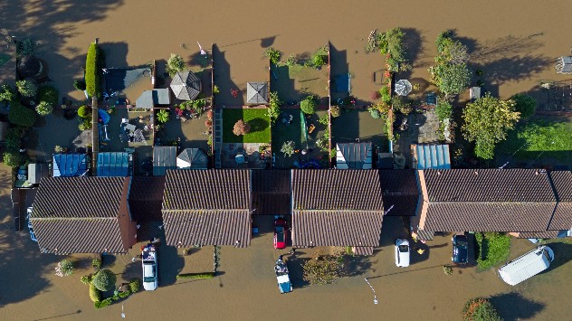
Flooded properties drone shot
River flooding
Flood defences along River Severn
Flooded fields
1/4
Properties in evacuated Retford, Nottinghamshire were flooded on Sunday. - © picture alliance

Storm Babet has now dissipated, and weather warnings are not currently in force. More than 1,250 properties have been flooded in England so far, while in Scotland some roads, including the A90, remain shut as engineers work on repairs.

Friday's Storm Babet live blogread more

All flood warnings in Scotland have now been lifted, though the effects of the storm will remain for months. Some residents of evacuated Brechin have been told they could be permanently removed from their homes due to the damage.

On Sunday, Derbyshire Police announced that a woman in her 80s had passed away in Chesterfield, bringing the current total to seven. Officers believe the cause of death to be related to the flooding.

Privacy Policy

In Ireland, flooding has been reported in County Cork as a train of persistent rain falls over the country on Monday. This band of rain pushes east into the UK overnight.

Further temporary flood defences have been deployed across at-risk areas of England in a bid to prevent the worst-case scenario for continued flooding this week.

See conditions at any time on the WeatherRadar.

Ryan Hathaway
More on the topic
Heavier rainfall over the week for some. Ireland & Scotland. . . Tuesday, 28 July 2026
Split image showing a Europe rainfall accumulation forecast map on the left with the highest totals across the UK, Ireland, and Scandinavia, and a satellite weather map on the right with a broad band of rain stretching across Ireland, Scotland, and northern Britain, highlighted by a rain cloud icon.
Tuesday, 28 July 2026

Ireland & Scotland

Heavier rainfall over the week for some
Icy spells in the Southern Hemisphere. Snow in the Andes. . . Tuesday, 28 July 2026
A composite image showing a temperature radar map of South America and a snow-covered town in Chile. The winter cold is bringing heavy snowfall to the Andes and, in some areas, snow down to lower altitudes.
Tuesday, 28 July 2026

Snow in the Andes

Icy spells in the Southern Hemisphere
Fourth heatwave of the year. Peaking Wednesday. . . Tuesday, 28 July 2026
Temperature map of England and Wales on Wednesday 29.07 showing widespread hot conditions, with temperatures reaching 33°C near Cambridge, 32°C around London, Norwich, and Southend-on-Sea, and a large heat warning symbol highlighting elevated heat risk.
Tuesday, 28 July 2026

Peaking Wednesday

Fourth heatwave of the year
All weather news
This might also interest you
Flooding, gales, and heavy snow. Storm Chandra. . . Tuesday, 27 January 2026
Split image showing aerial flooding in a town with muddy water covering roads on the left, and a rural road on the right blocked by heavy snowfall with vans stopped and a person walking in snow.
Tuesday, 27 January 2026

Storm Chandra

Flooding, gales, and heavy snow
A frozen start to the weekend. Icy conditions. . . Friday, 13 February 2026
UK temperature map dated 14.02 showing widespread subzero values in blue shading, with readings such as −4 in Glasgow, −3 in Dublin, and −2 in London, alongside a blue thermometer icon.
Friday, 13 February 2026

Icy conditions

A frozen start to the weekend
Super Typhoon Bavi threatens Taiwan. Up to 1,000 mm of rain. . . Wednesday, 8 July 2026
The image shows an intense tropical cyclone over the western Pacific, east of Taiwan and the Philippines. The centre of the system is depicted as a light purple and white vortex with a clearly visible eye, surrounded by a ring of red and orange areas indicating the strongest wind speeds. A white arrow marks the typhoon’s predicted track towards the north-west, in the direction of Taiwan. To the west of the storm lie the Philippines, with the cities of Manila and Cebu; to the north of these lies Taiwan, with Taipei. Further west, the Chinese coast, including Hong Kong, and parts of Vietnam can be seen. The coloured wind map shows predominantly green areas outside the storm’s core, indicating significantly weaker winds. White streamlines illustrate the typhoon’s anti-clockwise circulation in the Northern Hemisphere. The highest wind speeds are concentrated around the eye of the cyclone.
Wednesday, 8 July 2026

Up to 1,000 mm of rain

Super Typhoon Bavi threatens Taiwan
All articles
Weather & Radar

Weather & Radar is also available on

Google Play StoreApp Store

Company

Contact us Privacy Policy Legal info Accessibility statement

Services

Uploader

Socials

facebooktwittertikToklinkList