Home
Weather London
WeatherRadar
RainfallRadar
TemperatureRadar
WindRadar
LightningRadar
Weather News
Editor's Pick
Discover the app
Weather widget
Contact us
Apps
Career
    Home / Editor's Pick /

    Turbulent week ahead - Gales build again for Ireland

09:01
12 October 2026

Turbulent week ahead
Gales build again for Ireland

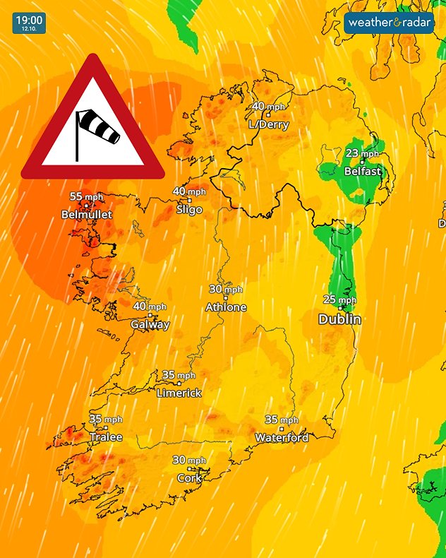
Wind forecast for 19:00 on 12.10 showing gusts up to 55 mph near Belmullet, 40 mph in Sligo and Galway, and a strong wind warning symbol.
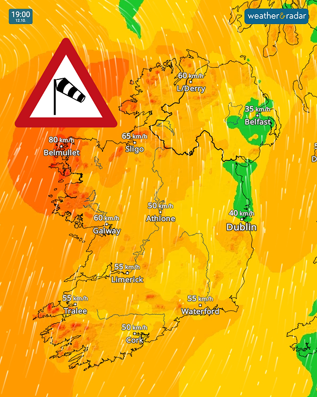
Wind forecast for 19:00 on 12.10 showing 80 km/h near Belmullet, 65 km/h near Sligo and 60 km/h near Galway and Derry, with a wind warning symbol.
1/2
Gusts spread again by Monday evening. (Swipe for km/h).

Conditions are calm across Ireland to start Monday, but by the evening, gusts spread again with gales in parts of the country.

By midday, the winds will start picking up in Co. Kerry and Co. Cork as they spread north through the country.

In the evening, Co. Mayo can expect gales. No land warnings have been issued but a marine weather warning for gales covers the north-western waters.

With rainfall moving in from the Atlantic along with the stronger winds, it will be an unpleasant evening in the west.

Similar conditions will be felt through the week, particularly on Wednesday, with little reprieve until Thursday at the earliest from the gusts.

Ryan Hathaway
More on the topic
Hurricane threatens the US coast. First storm of the season. . . Thursday, 8 October 2026
The WindRadar shows a powerful hurricane off the US Gulf Coast. Wind speeds of 75 miles per hour are being recorded around the centre of the storm.
Thursday, 8 October 2026

First storm of the season

Hurricane threatens the US coast
Much of Europe in storm mode. Twin low-pressure systems. . . Friday, 9 October 2026
WindRadar for Europe, showing wind speeds of up to 40 mph and wind socks over particularly windy regions.
Friday, 9 October 2026

Twin low-pressure systems

Much of Europe in storm mode
Dull start to the week under cloud cover. Little sun to be seen. . . Monday, 12 October 2026
Weather map showing extensive cloud over the UK and Ireland, a broad blue rain band approaching western Ireland and temperatures of 12–17°C.
Monday, 12 October 2026

Little sun to be seen

Dull start to the week under cloud cover
All weather news
This might also interest you
A frozen start to the weekend. Icy conditions. . . Friday, 13 February 2026
UK temperature map dated 14.02 showing widespread subzero values in blue shading, with readings such as −4 in Glasgow, −3 in Dublin, and −2 in London, alongside a blue thermometer icon.
Friday, 13 February 2026

Icy conditions

A frozen start to the weekend
Bright and warm conditions take hold. Spring-like outlook. . . Thursday, 23 April 2026
Split UK map showing warm temperatures up to 21 degrees in orange on the left and clear sunny conditions with temperatures from 12 to 18 degrees on the right, with sun icons across the country.
Thursday, 23 April 2026

Spring-like outlook

Bright and warm conditions take hold
Historic Storm Éowyn arrives. On this day.... . . Saturday, 24 January 2026
Split image showing a person in a yellow jacket struggling against strong winds and heavy rain on a street at night on the left, and an Irish wind forecast map on the right with red and purple shading, gusts up to 75 mph, and a wind warning icon, divided by a curved white line.
Saturday, 24 January 2026

On this day...

Historic Storm Éowyn arrives
All articles
Weather & Radar

Weather & Radar is also available on

Google Play StoreApp Store

Company

Contact us Privacy Policy Legal info Accessibility statement

Services

Uploader

Socials

facebooktwittertikToklinkList